Typhoon Tip facts for kids
| Typhoon (JMA scale) | |
|---|---|
| Category 5 super typhoon (SSHWS) | |
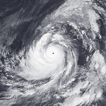
Typhoon Tip at its record peak intensity on October 12, 1979
|
|
| Formed | October 4, 1979 |
| Dissipated | October 19, 1979 |
| Highest winds | 10-minute sustained: 260 km/h (160 mph) 1-minute sustained: 305 km/h (190 mph) |
| Lowest pressure | 870 hPa (mbar); 25.69 inHg (Worldwide record low) |
| Fatalities | 86 direct, 13 indirect |
| Areas affected | Guam, Japan |
| Part of the 1979 Pacific typhoon season | |
Typhoon Tip, also called Typhoon Warling in the Philippines, was the largest and strongest tropical cyclone ever recorded. It was the 19th tropical storm and 12th typhoon of the 1979 Pacific typhoon season. Tip started as a small weather disturbance on October 4, 1979, near Pohnpei.
At first, another storm nearby stopped Tip from getting stronger. But once that storm moved away, Tip grew very quickly. After passing Guam, it became incredibly powerful. On October 12, it reached its top strength with winds of 305 km/h (190 mph). It also had the lowest air pressure ever recorded in a storm, at 870 mbar. At its biggest, Tip was an amazing 2,220 km (1,380 mi) wide. This made it the largest tropical cyclone on record. Tip slowly weakened as it moved west-northwest, then turned northeast. It hit southern Japan on October 19 and soon after became a weaker storm.
U.S. Air Force Reconnaissance planes flew into Typhoon Tip 60 times. This made it one of the most watched storms ever. Heavy rain from Tip caused a flood wall to break at a U.S. Marine Corps camp in Japan. This led to a fire that sadly killed 13 Marines and injured 68. Across Japan, the typhoon caused a lot of damage, leading to 42 deaths. Shipwrecks caused by the storm left 44 people dead or missing.
Contents
How Typhoon Tip Formed and Grew
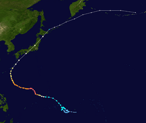
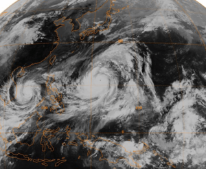
Typhoon Tip began from a large area of low pressure that stretched from the Philippines to the Marshall Islands. On October 3, a small storm formed southwest of Guam. On the same day, the system that would become Typhoon Tip started south of Pohnpei.
At first, the nearby storm stopped Tip from getting much stronger. But Tip slowly became more organized as it moved west. It moved slowly and unevenly, even making a loop southeast of Chuuk. On October 4, a special plane called a Reconnaissance Aircraft flew into the system. It confirmed that a storm center was forming. The next day, the Joint Typhoon Warning Center (JTWC) named it Tropical Depression Twenty-Three.
Tip Becomes a Strong Typhoon
The tropical depression grew into Tropical Storm Tip. But it didn't get much stronger because of the other storm nearby. After moving slowly for several days, Tip began to move steadily northwest on October 8. By then, the other storm had weakened. At first, people thought Tip would continue northwest and hit Guam. But on October 9, it turned west, passing about 45 km (28 mi) south of the island. Later that day, Tip became a full typhoon.
Typhoon Tip quickly gained strength over the open waters of the western Pacific Ocean. On October 10, it became a Category 4 storm on the Saffir–Simpson Hurricane Scale. The next day, it was called a "super typhoon." The air pressure in its center dropped very quickly. During this time, the typhoon grew incredibly large, reaching a record width of 2,220 km (1,380 mi).
Tip kept getting stronger. On October 12, the Reconnaissance Aircraft measured a world-record low pressure of 870 mbar. The typhoon had winds of 305 km/h (190 mph). It was located about 840 km (520 mi) west-northwest of Guam. At its strongest, the typhoon's eye was only 15 km (9.3 mi) wide.
Tip Weakens and Hits Japan
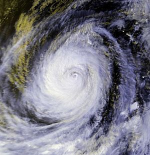
After reaching its peak strength, Tip weakened slightly to a 230 km/h (145 mph) typhoon. It stayed at this strength for several days as it moved west-northwest. For five days, its strong winds stretched over 1,100 km (685 mi) from its center.
On October 17, Tip began to weaken and shrink. The next day, it turned northeast because of a nearby weather system. It passed about 65 km (45 mi) east of Okinawa and sped up to 75 km/h (46 mph). On October 19, Tip made landfall on the Japanese island of Honshū. Its winds were about 130 km/h (80 mph). The typhoon quickly moved northeast through Japan and then became a weaker storm over northern Honshū. What was left of Tip continued moving northeast and slowly lost strength. It was last seen near Alaska.
Typhoon Tip's Impact
As Typhoon Tip passed near Guam, it brought very heavy rain. One Air Force base recorded 23.1 cm (9.09 in) of rain. The outer parts of Tip also caused moderate rain in the mountains of the Philippines.
Camp Fuji Fire
Heavy rainfall from Tip caused a flood wall to break at Camp Fuji. This was a training camp for the United States Marine Corps near Yokosuka, Japan. Marines at the camp were staying in huts at the bottom of a hill. A fuel storage area was on top of the hill.
When the wall broke, hoses were torn from two large fuel tanks. A lot of fuel flowed down the hill. A heater in one of the huts then caused the fuel to catch fire. This started a huge fire that sadly killed 13 Marines and injured 68 others. The fire destroyed the camp's barracks, 15 huts, and other buildings. Firefighters from nearby areas arrived within two hours. The barracks were rebuilt, and a memorial was made to remember those who died in the fire.
Damage in Japan
Typhoon Tip passed about 65 km (40 mi) from Okinawa. Winds there reached 72 km/h (44 mph), with gusts up to 112 km/h (69 mph). The typhoon caused millions of dollars in damage to Japan's farming and fishing industries.
Eight ships were either stuck or sunk by Tip. This led to 44 fishermen being killed or missing. A Chinese cargo ship broke in half because of the typhoon, but its crew of 46 people was rescued. The heavy rain caused over 600 mudslides in the mountains of Japan. More than 22,000 homes were flooded. It is thought that 42 people died, 71 were missing, and 283 were hurt.
About 27 bridges and 105 dikes were destroyed by the storm. After the typhoon, at least 11,000 people were left without a home. Transportation was also affected. About 200 trains and 160 domestic airline flights were canceled. Tip was called the most severe storm to hit Japan in 13 years.
Typhoon Tip's Records
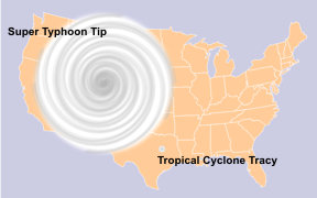
Typhoon Tip holds the record for the largest tropical cyclone ever. It had a huge diameter of 2,220 km (1,380 mi). This is almost twice as big as the previous record holder, Typhoon Marge in 1951. At its largest, Tip was nearly half the size of the United States. When Tip was at its strongest, the temperature inside its eye was 30° C (86° F), which is very warm for a tropical cyclone. Also, with 10-minute winds of 260 km/h (160 mph), Typhoon Tip is considered the strongest cyclone by the Japan Meteorological Agency.
Tip was also the most intense tropical cyclone in the world. It had a record-low pressure of 870 mbar. This was 6 mbar lower than the previous record set by Typhoon June in 1975. Tip's records still stand today. However, planes stopped flying into storms in the western Pacific Ocean in 1987. So, some people wonder if there might have been slightly stronger cyclones that were not measured.
Some researchers believe that two other typhoons, Angela (1995) and Gay (1992), might have been stronger than Tip. This is based on a method called the Dvorak technique. Also, Cyclone Monica in 2006 was estimated to have a pressure of 869 mb using Dvorak classifications, but this data is not considered fully accurate. Because of this, it's not completely certain if Tip still holds the world record for lowest pressure. Despite its record strength and the damage it caused, the name Tip was not removed from the list of storm names. It was used again in 1983, 1986, and 1989.
Related pages
See also
 In Spanish: Tifón Tip para niños


