
Hurricane Ioke facts for kids
Hurricane Ioke (also known as Typhoon Ioke) was the strongest hurricane ever recorded in the central Pacific Ocean. It was the first big storm to form in the Central Pacific in 2006. Ioke was a very long-lasting and incredibly powerful storm that traveled across the Pacific. It became a Category 5 hurricane twice. Later, as a typhoon, it reached Category 5 strength one more time before getting weaker.
Ioke did not hit any places where people live permanently while it was a hurricane or typhoon. However, it passed over Johnston Atoll as a Category 2 hurricane. It also passed over Wake Island as a Category 5 typhoon. Even though it was super strong, Ioke only caused moderate damage to Wake Island. Luckily, no one died because of this storm.
Contents
How the Storm Formed and Traveled

The storm started in the third week of August. It was a tropical disturbance south of the Hawaiian Islands. A tropical disturbance is like a messy area of clouds and thunderstorms. It grew stronger and became a tropical depression on August 19. This was about 775 miles south of Honolulu.
It kept getting stronger. The Central Pacific Hurricane Center named the system Ioke. This name is Hawaiian for "Joyce." It was the first tropical storm to form in the Central Pacific since 2002.
Ioke quickly started to get much stronger very fast. It became a hurricane just 24 hours after it formed. It safely avoided the Hawaiian Islands. It continued to get stronger quickly. It became a major hurricane (Category 3 or stronger) on August 21. Later that day, Ioke became an even stronger Category 4 hurricane.
On August 22, it started to weaken a bit. This was because it moved over cooler water. It also went through something called an eyewall replacement cycle. This is when a hurricane's inner eye wall collapses and a new, larger one forms. This can make the storm temporarily weaker. Ioke was downgraded back to a Category 2 storm. As a Category 2 storm, Ioke passed by Johnston Atoll.

The storm began to get much stronger again late on August 23. It moved over warmer water. It reached major hurricane status for the second time. From there, conditions became even better for it to grow.
Overnight between August 24 and August 25, Ioke strengthened very quickly. It became a Category 5 hurricane on August 25. This was the first storm from the Central Pacific to reach that strength while still in the Western Hemisphere. Ioke then traveled through an area that was perfect for hurricanes to grow. It stayed very strong for a long time. Ioke also became the strongest hurricane ever in the Central Pacific. Its central pressure was 921 mbar (27.19 inHg) at that point. This pressure later dropped to 920 mbar.
Ioke's strength went up and down after that. It weakened back to a Category 4 while going through another eyewall replacement cycle. It then got back to Category 5 strength on August 26. Ioke stayed at that strength until it crossed the International Date Line that evening. When it crossed the date line, it became Typhoon Ioke. The storm weakened to Category 4 strength for a short time. But by August 29, it had regained Category 5 strength for the third time.
After staying at Category 5 strength for 12 hours, Ioke weakened back to a Category 4 for the last time on August 30. It was getting close to Wake Island. Ioke passed almost directly over Wake Island on September 1. It kept moving west-northwest. It slowly got weaker over cooler waters.
On September 3, the typhoon started to curve north. It moved away from Japan. It also weakened faster. Ioke began to change into an extratropical cyclone late on September 4. This happens when a tropical storm loses its tropical features. It becomes more like a regular weather system. This was due to strong wind shear (changes in wind speed or direction) and rapidly cooling seas. The storm became completely extratropical east of the Kamchatka Peninsula by September 7.
Amazing Records Set by Ioke

- Ioke was the first Category 5 hurricane ever to form in the Central Pacific. It reached that strength while still in the Central Pacific. It was also only the fifth Category 5 hurricane ever recorded in the Central Pacific. The other four came from the Eastern or Western Pacific. It was the first one since Hurricane John in 1994.
- Ioke was the strongest hurricane ever recorded in the Central Pacific. Its pressure at its strongest point was 920 mbar (27.179 inHg). Lower pressure means a stronger storm.
- Ioke tied with Hurricane Emilia from 1994. Both storms reached Category 5 strength twice as hurricanes in the Northern Pacific. Ioke then got even stronger to become a Category 5-equivalent typhoon.
- Ioke spent more time at Category 4 strength or higher than any other Central or East Pacific hurricane. It stayed at that strength for a total of 34 reports (31 in a row). Each report was every 6 hours. The old record was held by Hurricane Paka.
What Happened Because of Ioke
Even though Ioke was incredibly strong and hit two small land areas, the damage was not as bad as expected. There was little damage on Johnston Atoll. Damage to important buildings and systems (called infrastructure) on Wake Island was also less than expected. This was true even though the strongest part of Ioke, its eyewall, passed very close to the island.
Johnston Atoll
The National Weather Service reported that the eastern eyewall of Ioke passed over the uninhabited Johnston Atoll. This means the island was hit by very strong hurricane-force winds.
Twelve people from a United States Air Force ship were on the island. They had to leave their ship and go into a special bunker that could withstand hurricanes. They were reported safe the next day. A special flight (called a reconnaissance flight) checked the island. It reported that there was little damage.
Wake Island

Because Typhoon Ioke was expected to pass near Wake Island, all 188 people living and working there were evacuated. They were flown in two C-17 Globemaster III planes to Oahu in Hawaii.
The typhoon had incredibly powerful winds. They were estimated to reach up to 190 miles per hour. These winds damaged weather sensors on the island. The sensors stopped working after reporting a 100 mph gust. A mission by the Coast Guard checked the island. They found that the typhoon caused moderate damage. This included roofs blown off, damaged sides of buildings, and trees knocked down. However, the damage could be fixed. The main important buildings and systems on the island were still working.
Images for kids
-
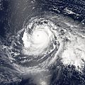
Typhoon Ioke gaining strength after crossing the International Date Line on August 28
-
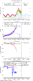
Data recorded at Wake Island during the passage of Ioke
-
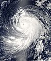
Typhoon Ioke near Wake Island on August 31
-
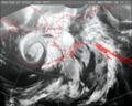
The extratropical remnants of Ioke over the Bering Sea, west of Alaska on September 7
-
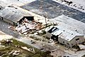
Damage on Wake Island after Ioke


See also
 In Spanish: Huracán Ioke para niños
