
Etchū Province facts for kids

Etchū Province (越中国, Etchū no kuni) was an old province of Japan. It was located in the area that is now Toyama Prefecture on the island of Honshū. Etchū Province was sometimes called Esshū (越州), along with Echizen and Echigo Provinces.
This province shared its borders with several other provinces. These included Echigo, Shinano, Hida, Kaga, and Noto provinces. The main capital city of Etchū Province was Takaoka.
Contents
A Look Back: The History of Etchū Province

Over many centuries, the borders of Etchū Province changed a few times. For example, the Noto Peninsula and what became Noto Province were once part of Etchū. This area was separated from Etchū during the time of Empress Genshō.
Later, in the Meiji period (which began in 1868), Japan went through big changes. The old system of provinces was replaced by a new system of prefectures. This change happened in the 1870s. During this time, the maps of Japan and Etchū Province were reformed. Etchū Province then became what we know today as Toyama Prefecture.
Sacred Places: Shrines and Temples of Etchū
In ancient Japan, each province had important Shinto shrines. These were called ichinomiya, meaning the "first" or "chief" shrine of the province. For Etchū Province, the main Shinto shrines were Takase jinja, Keta jinja, and Oyama jinja. These shrines were very important places for people to worship and connect with their spiritual beliefs.
Related pages
Images for kids
-
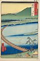
Hiroshige ukiyo-e "Etchū" in "The Famous Scenes of the Sixty Provinces" (六十余州名所図会), depicting Funa-hashi, a pontoon bridge

See also
 In Spanish: Provincia de Etchū para niños
