
Takaoka, Toyama facts for kids
Quick facts for kids
Takaoka
高岡市
|
|||
|---|---|---|---|

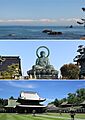
From top: view of Tateyama Mountains from Amaharashi Coast, Takaoka Daibutsu, and Zuiryū-ji
|
|||
|
|||

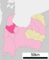
Location of Takaoka in Toyama Prefecture
|
|||

Takaoka
Location in Japan
|
|||
| Country | Japan | ||
| Region | Chūbu (Hokuriku) | ||
| Prefecture | Toyama | ||
| First official recorded | 701 AD | ||
| City settled | April 1, 1889 | ||
| Area | |||
| • Total | 209.57 km2 (80.92 sq mi) | ||
| Population
(March 10, 2018)
|
|||
| • Total | 173,086 | ||
| • Density | 825.910/km2 (2,139.10/sq mi) | ||
| Time zone | UTC+9 (Japan Standard Time) | ||
| Symbols | |||
| • Tree | Persera thunbergii | ||
| • Flower | Katakuri (Katakago) | ||
| • Flowering tree | Sakura | ||
| Phone number | 0766-20-1111 | ||
| Address | 7-50 Hirokōji, Takaoka-shi, Toyama-ken 933-8601 | ||
| Climate | Cfa | ||


Takaoka (高岡市 (Takaoka-shi)) is a city in the northwestern part of Toyama Prefecture, Japan. It is the second largest city in Toyama Prefecture, right after Toyama City.
Takaoka is a main hub for the western part of Toyama Prefecture. This area is known as "Gosei," which means "west of Kureha hill." The eastern part of the prefecture is called "Goto," meaning "east of Kureha hill."
As of 2018, about 173,086 people lived in Takaoka. The city covers an area of 209.57 square kilometers (80.92 sq mi).
Contents
- Geography of Takaoka
- Population of Takaoka
- History of Takaoka
- Education in Takaoka
- Getting Around Takaoka
- Takaoka's International Connections
- Fun Places to Visit in Takaoka
- Exciting Festivals in Takaoka
- Takaoka Mikurumayama Festival (May 1)
- Fushiki Hikiyama Festival (May 15)
- Goin Festival (June 19/20)
- Toide Tanabata Festival (July 3–7)
- Takaoka Tanabata Festival (Early August)
- Fukuoka Machi Tsukurimon Festival (September 23/24)
- Nakada Scarecrow Festival (Late September)
- Takaoka Manyō Festival (First Weekend of October)
- Takaoka Nabe Festival (Mid-January)
- Famous People from Takaoka
- Images for kids
- See also
Geography of Takaoka
Takaoka covers about 5% of Toyama Prefecture's total area. The city has different types of land. This includes real estate, farms, mountains, forests, and public areas like parks.
The city stretches 19.2 kilometers (11.9 mi) from north to south. It is 24.5 kilometers (15.2 mi) wide from east to west. Takaoka shares its borders with four cities in Toyama Prefecture. These are Himi, Oyabe, Tonami, and Imizu. It also borders two towns in Ishikawa Prefecture.
Mountains ranging from 150 to 300 meters (490 to 980 ft) run through Takaoka. The Shogawa River and Oyabegawa River flow through the city. Many smaller rivers also weave through the city center.
Neighboring Cities and Towns
Takaoka is surrounded by these places:
- Ishikawa Prefecture
- Hōdatsushimizu
- Tsubata
- Toyama Prefecture
- Himi
- Imizu
- Oyabe
- Tonami
Takaoka's Climate
Takaoka has a humid subtropical climate (Cfa). This is common along the Sea of Japan coast. Winters in Toyama Prefecture can have a lot of snow. Sometimes, there is very heavy snowfall. For example, in 2006, the snow was 1.4 meters (4.6 ft) high. In 2011, it reached 1.27 meters (4.17 ft).
The average temperature in 2010 was 14.5°C (58.1°F). The average humidity was 79%. The city received about 2,665.5 mm (104.94 in) of rain that year. There were 1,634 hours of sunlight.
| Climate data for Fushiki, Takaoka, Toyama (1991−2020 normals, extremes 1887−present) | |||||||||||||
|---|---|---|---|---|---|---|---|---|---|---|---|---|---|
| Month | Jan | Feb | Mar | Apr | May | Jun | Jul | Aug | Sep | Oct | Nov | Dec | Year |
| Record high °C (°F) | 20.3 (68.5) |
23.3 (73.9) |
25.6 (78.1) |
32.0 (89.6) |
32.5 (90.5) |
37.3 (99.1) |
38.3 (100.9) |
39.7 (103.5) |
38.5 (101.3) |
34.1 (93.4) |
28.9 (84.0) |
23.5 (74.3) |
39.7 (103.5) |
| Mean daily maximum °C (°F) | 6.0 (42.8) |
7.0 (44.6) |
11.3 (52.3) |
16.7 (62.1) |
21.6 (70.9) |
24.7 (76.5) |
29.1 (84.4) |
30.9 (87.6) |
26.6 (79.9) |
21.2 (70.2) |
15.3 (59.5) |
9.3 (48.7) |
18.3 (65.0) |
| Daily mean °C (°F) | 2.9 (37.2) |
3.3 (37.9) |
6.6 (43.9) |
11.7 (53.1) |
16.8 (62.2) |
20.8 (69.4) |
25.1 (77.2) |
26.7 (80.1) |
22.7 (72.9) |
17.0 (62.6) |
11.1 (52.0) |
5.7 (42.3) |
14.2 (57.6) |
| Mean daily minimum °C (°F) | 0.2 (32.4) |
0.1 (32.2) |
2.5 (36.5) |
7.3 (45.1) |
12.7 (54.9) |
17.8 (64.0) |
22.3 (72.1) |
23.5 (74.3) |
19.4 (66.9) |
13.3 (55.9) |
7.4 (45.3) |
2.6 (36.7) |
10.8 (51.4) |
| Record low °C (°F) | −12.1 (10.2) |
−11.3 (11.7) |
−8.7 (16.3) |
−2.6 (27.3) |
1.8 (35.2) |
8.5 (47.3) |
12.7 (54.9) |
14.0 (57.2) |
8.4 (47.1) |
1.8 (35.2) |
−0.9 (30.4) |
−8.7 (16.3) |
−12.1 (10.2) |
| Average precipitation mm (inches) | 272.7 (10.74) |
161.6 (6.36) |
150.6 (5.93) |
121.9 (4.80) |
115.4 (4.54) |
159.4 (6.28) |
223.8 (8.81) |
194.2 (7.65) |
205.0 (8.07) |
161.2 (6.35) |
221.3 (8.71) |
294.0 (11.57) |
2,281 (89.80) |
| Average snowfall cm (inches) | 107 (42) |
71 (28) |
15 (5.9) |
1 (0.4) |
0 (0) |
0 (0) |
0 (0) |
0 (0) |
0 (0) |
0 (0) |
0 (0) |
46 (18) |
238 (94) |
| Average precipitation days (≥ 0.5 mm) | 24.4 | 19.8 | 17.8 | 13.6 | 11.8 | 11.0 | 13.7 | 10.9 | 14.1 | 13.9 | 18.4 | 23.3 | 192.7 |
| Average snowy days (≥ 1 cm) | 12.7 | 10.2 | 2.9 | 0.2 | 0 | 0 | 0 | 0 | 0 | 0 | 0.1 | 5.5 | 31.6 |
| Average relative humidity (%) | 81 | 77 | 71 | 69 | 72 | 79 | 80 | 77 | 77 | 75 | 76 | 80 | 76 |
| Mean monthly sunshine hours | 61.1 | 85.7 | 137.6 | 176.4 | 204.6 | 158.8 | 160.3 | 205.5 | 147.3 | 146.3 | 104.6 | 66.8 | 1,650.1 |
| Source: Japan Meteorological Agency | |||||||||||||
Population of Takaoka
The number of people living in Takaoka has slowly gone down over the last 40 years.
| Historical population | ||
|---|---|---|
| Year | Pop. | ±% |
| 1970 | 170,841 | — |
| 1980 | 186,900 | +9.4% |
| 1990 | 187,869 | +0.5% |
| 2000 | 185,682 | −1.2% |
| 2010 | 176,061 | −5.2% |
| 2020 | 166,393 | −5.5% |
People from Other Countries
As of 2011, Takaoka had many people from other countries. About 1,430 residents were from Brazil. Around 700 people were from China, and about 360 were from the Philippines.
History of Takaoka
The area where Takaoka is today was once part of an old province called Etchū Province. Its main government office was near the modern city. In the 8th century, a government official named Ōtomo no Yakamochi worked here. He wrote many waka poems during his five years in the area. Because of this, Takaoka is sometimes called "Manyō City."
The Takaoka region was first known as Sekino. In 1609, Maeda Toshinaga of Kaga Domain took control. He renamed it Takaoka, using a word from a religious poem. Also, Takaoka Castle was built on a slightly high area. "Taka" means "high" and "Oka" means "hill," which might be another reason for the name.
In 1615, the castle was removed by order of the Tokugawa shogunate. However, the Maeda clan helped Takaoka grow as a city for business and industry. This is when Takaoka became famous for its copperware and lacquerware.
On April 1, 1889, Takaoka became one of Japan's first 30 official cities. In July 1899, Fushiki Port was opened for trade with other countries.
Later, on November 1, 2005, the town of Fukuoka joined with Takaoka.
Education in Takaoka
Takaoka has several schools and universities.
Colleges and Universities
- University of Toyama – Takaoka campus
- Takaoka University of Law
Schools for Kids
The city runs 26 public elementary schools and 12 public junior high schools. The Toyama Prefectural Board of Education runs eight public high schools. There are also three private high schools. Takaoka also has one special education school. The prefecture runs four more special education schools.
Getting Around Takaoka
You can travel around Takaoka by train and highway.
Train Lines
 West Japan Railway Company (JR West) - Hokuriku Shinkansen
- Shin-Takaoka
- West Japan Railway Company (JR West) - Himi Line
- Takaoka - Etchū-Nakagawa - Nōmachi - Fushiki - Etchū-Kokubu - Amaharashi
- West Japan Railway Company (JR West) - Jōhana Line
- Takaoka - (Shin-Takaoka) - Futatsuka - Hayashi - Toide
 Ainokaze Toyama Railway
- Fukuoka - Nishi-Takaoka - (Takaoka-Yabunami) - Takaoka
- Manyosen - Man'yōsen Takaoka Kidō Line
- Takaoka Station - Suehirochō - Kataharamachi - Sakashitamachi - Kyūkan Iryō Center-mae - Hirokōji - Shikino Chūgakkō-mae - Shimin Byōin-mae - Ejiri - Asahigaoka - Ogino - Shin-Nōmachi - Yonejimaguchi -Nōmachiguchi - Shin-Yoshihisa - Yoshihisa
- Manyosen - Man'yōsen Shinminatokō Line
- Naka Shinminato
Major Roads
- Hokuriku Expressway
 National Route 8
 National Route 156
 National Route 160
 National Route 415
Takaoka's International Connections
Takaoka has friendly relationships with cities in other countries:
 Mirandópolis, São Paulo, Brazil (since 1974)
 Fort Wayne, Indiana, United States (since 1977)
 Jinzhou, Liaoning, China (friendship city since August 1985)
- Liaoyang, Liaoning, China (friendship city since August 2010)
Fun Places to Visit in Takaoka
Takaoka has many interesting spots to explore.

The Great Buddha of Takaoka
This huge statue is almost 16 meters (52 ft) tall. It is the third largest Buddha statue in Japan. The current Buddha is made of Takaoka bronze. It was finished in 1933 after an older wooden statue burned down. You can find it next to the Daibutsu Temple in a living area of Takaoka.
Kojo Park
Kojo Park used to be the site of Takaoka Castle. It's a short walk from the city center. Inside the park, you can find the Imizu Shrine and the Takaoka Museum. There's also the Takaoka Zoo, the Civic Hall, and a Civic Gymnasium. The park is full of nature. The moat around the park is a popular place to see cherry blossoms in spring.

Zuiryū-ji Temple
This Zen temple was completed in 1663. It is a National Treasure of Japan. The temple was built to honor Maeda Toshinaga, who helped build Takaoka. It shows the amazing architecture from the early Edo period.
The Amaharashi Coast
The Amaharashi Coast is north of Takaoka city. It has sandy beaches and great views. You can see the Onnaiwa Rock with the beautiful Tateyama mountains in the background.
Kanayamachi Area
Kanayamachi is a part of Takaoka with old buildings. These include warehouses and houses that have been kept since the Meiji period. This area is where Takaoka copperware first started to be made.
Sakuradani Kofun
The Sakuradani Kofun are groups of old burial mounds. Two of these mounds are very important. They are recognized as a National Historic Site of Japan.
Exciting Festivals in Takaoka
Takaoka hosts many lively festivals throughout the year.
Takaoka Mikurumayama Festival (May 1)
This festival began when Maeda Toshinaga gave a special float to the people of Takaoka. Seven colorful floats are part of the festival. They are made in the bright Momoyama style. These floats parade through the streets of Takaoka.
Fushiki Hikiyama Festival (May 15)
This festival in the port town of Fushiki is known as 'Kenkayama' or "fighting floats." During the day, the floats are decorated with flowers. At night, they are lit up with paper lanterns. The floats are crashed into each other to the beat of war drums.
Goin Festival (June 19/20)
The Goin festival celebrates Maeda Toshinaga's kindness to the city's metal casters. People worship documents with his official seal. During the festival, the Yagaefu dance is performed. This is a special dance with bamboo sticks in the Kanayamachi streets.

Toide Tanabata Festival (July 3–7)
This festival features about 1,000 tanabata decorations. Some are very tall, up to 20 meters (66 ft) high. They create a large tunnel over the town's main street.
Takaoka Tanabata Festival (Early August)
This festival is a symbol of summer in Takaoka. Thousands of large tanabata line the streets. It celebrates the legend of Orihime and Hikoboshi. These two deities are said to meet only once a year.
Fukuoka Machi Tsukurimon Festival (September 23/24)
This festival has been celebrated for over 300 years. Sculptures of local sights and famous characters are made. They are crafted from fruits and vegetables. These amazing sculptures are displayed all over the town.
Nakada Scarecrow Festival (Late September)
Scarecrows are made from everyday materials like straw and wood. They show current events and famous characters. These scarecrows are displayed in the main shopping area of the Nakada district.
Takaoka Manyō Festival (First Weekend of October)
This big autumn event celebrates the Manyō tradition. It features a poetry reading marathon. People recite the entire Manyō poetry collection. This reading lasts for three days and three nights. Many people take turns reading.
Takaoka Nabe Festival (Mid-January)
Fresh fish and shellfish from the Sea of Japan are cooked. They are prepared in large pots. These pots are made using local metal casting techniques.
Famous People from Takaoka
Many notable individuals have come from Takaoka:
- Kinjirō Ashiwara (1850–1937), also known as Shogun Ashiwara (葦原将軍, Ashiwara Shōgun)
- Fujiko Fujio (1933–1996), a pen name for Hiroshi Fujimoto. He helped create famous characters like Doraemon.
- Takamine Jōkichi (1854–1922), a scientist in engineering and medicine. He helped start the RIKEN Natural Sciences Institute. He also discovered Adrenaline.
- Eichi Kanamori (1908–2001), a "Living National Treasure" for his metal engraving skills in Takaoka copperware.
- Izumi Matsumoto, a manga artist.
- Sosen Mishima (1876–1934), an author and theater critic.
- Kingetsu Murozaki (1891–1977), a composer and founder of a music school in Tokyo. He wrote a famous song about the sunset at Takaoka's Kojo Park.
- Namori, a manga artist and author of YuruYuri. This story takes place in a fictional area of Takaoka.
- Komin Ozawa (born in 1941), a "Living National Treasure." He is known for his skill in making metal objects using a special casting method.
- Yōjirō Takita (born in 1955), a filmmaker. His 2008 movie Okuribito won an Academy Award.
Images for kids
-
From top: view of Tateyama Mountains from Amaharashi Coast, Takaoka Daibutsu, and Zuiryū-ji
-

Flag of Takaoka
-

Emblem of Takaoka
-
Location of Takaoka in Toyama Prefecture
See also
 In Spanish: Takaoka (Toyama) para niños
