Tochigi Prefecture facts for kids
Quick facts for kids Tochigi Prefecture |
|||||||||
|
|||||||||
 |
|||||||||
| Capital | Utsunomiya | ||||||||
| Region | Kantō | ||||||||
| Island | Honshū | ||||||||
| Governor | Tomikazu Fukuda | ||||||||
| Area (rank) | 6,408.28 km² (20th) | ||||||||
| - % water | 0.2% | ||||||||
| Population (January 1, 2003) | |||||||||
| - Population | 2,011,313 (20th) | ||||||||
| - Density | 314 /km² | ||||||||
| Districts | 6 | ||||||||
| Municipalities | 31 | ||||||||
| ISO 3166-2 | JP-09 | ||||||||
| Website | English web site | ||||||||
| Prefectural Symbols | |||||||||
| - Flower | Yashio tsutsuji (Rhododendron albrechtii) |
||||||||
| - Tree | Japanese horse chestnut (Aesculus turbinata) |
||||||||
| - Bird | Blue-and-white Flycatcher (Cyanoptila cyanomelana) |
||||||||
| - Fish | |||||||||
 Symbol of Tochigi Prefecture |
|||||||||
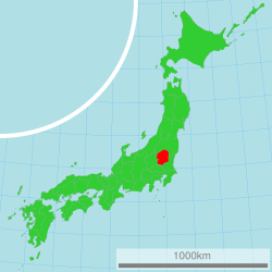
Tochigi Prefecture (栃木県, Tochigi-ken) is a special area in Japan. It is called a prefecture. Tochigi is located in the Kantō region on the island of Honshu. The main city and capital of Tochigi is Utsunomiya.
Contents
What is the history of Tochigi Prefecture?
Tochigi Prefecture was created from an older area called Shimotsuke Province. This means its history goes back a long time.
Famous historical sites in Tochigi
Tochigi is home to a very important place called Nikko Toshogu. This site is so special that it is listed as a World Heritage Site. It is located in the city of Nikkō.
Where is Tochigi Prefecture located?
Tochigi is in the central part of Japan's main island, Honshu. It shares its borders with several other prefectures. These include Ibaraki Prefecture, Gunma Prefecture, Saitama Prefecture, and Fukushima Prefecture.
Natural beauty and national parks
A large part of Tochigi Prefecture is covered by beautiful nature. About 21% of the prefecture's total land area is protected as National Parks. These parks help keep the natural environment safe.
Important shrines and temples
Tochigi Prefecture has many important religious sites. Two of the main Shinto shrines, known as ichinomiya, are Futarasan jinja and Futarayama jinja. These are places where people go to worship.
Learn more about Japan
If you want to know more about Japan, you can check out these topics:
- Provinces of Japan
- Prefectures of Japan
- List of regions of Japan
- List of islands of Japan
- Tochigi S.C. (a local sports team)
Images for kids
-
Tochigi Green Stadium in Utsunomiya.
See also
 In Spanish: Prefectura de Tochigi para niños
 | Dorothy Vaughan |
 | Charles Henry Turner |
 | Hildrus Poindexter |
 | Henry Cecil McBay |


