
Fukushima Prefecture facts for kids
Quick facts for kids Fukushima Prefecture |
|||||||||
|
|||||||||
 |
|||||||||
| Capital | Fukushima (city) | ||||||||
| Region | Tōhoku | ||||||||
| Island | Honshū | ||||||||
| Governor | Masao Uchibori | ||||||||
| Area (rank) | 13,782.54 km² (3rd) | ||||||||
| - % water | 0.9% | ||||||||
| Population (2010-10-01) | |||||||||
| - Population | 2,028,752 (17th) | ||||||||
| - Density | 154 /km² | ||||||||
| Districts | 13 | ||||||||
| Municipalities | 61 | ||||||||
| ISO 3166-2 | JP-07 | ||||||||
| Website | Fukushima Prefecture | ||||||||
| Prefectural Symbols | |||||||||
| - Flower | Nemotoshakunage (Rhododendron brachycarpum) | ||||||||
| - Tree | Japanese zelkova (Zelkova serrata) | ||||||||
| - Bird | Narcissus Flycatcher (Ficedula narcissina) | ||||||||
| - Fish | |||||||||
 Symbol of Fukushima Prefecture |
|||||||||

Fukushima Prefecture (pronounced Foo-koo-shee-mah) is a special area in Japan. It's located in the Tōhoku region on the big island of Honshū. The main city, or capital, is also called Fukushima City.
A big event happened here in March 2011. The Fukushima Daiichi Nuclear Power Plant had a serious accident. This event caused many people, especially from the Futaba District, to move away from their homes for safety.
Contents
History of Fukushima
Before 1871, the area we now call Fukushima Prefecture was known as Mutsu Province. This was a very old way of dividing Japan.
In 1871, Japan changed its system. The lands of eleven different clans were joined together. They formed three new prefectures: Fukushima, Wakamatsu, and Iwaki.
Later, on August 21, 1876, these three prefectures were combined into one. This is how the Fukushima Prefecture we know today was officially created.
Geography of Fukushima
Fukushima is the southernmost prefecture in the Tōhoku region. It's the closest part of Tōhoku to Tokyo, which is about 300 kilometers (186 miles) further south. Fukushima is located between 37 and 38 degrees north latitude.
The prefecture is divided into three main areas by mountain ranges. These areas are:
- Aizu (in the west)
- Nakadōri (in the middle)
- Hamadōri (on the east coast)
Hamadōri Region
Hamadōri is the area along the Pacific Ocean coast. It's the flattest part of Fukushima and has the mildest weather. This means it doesn't get too hot or too cold.
Nakadōri Region
Nakadōri is in the center of the prefecture. It's the most important area for farming. Many different crops are grown here. The capital city, Fukushima City, is located in this region.
Aizu Region
Aizu is the western part of Fukushima. It's a very popular place for tourism. This region has many beautiful mountains, clear lakes, and thick forests. In winter, it gets a lot of snow, making it a great place for winter activities.
Cities in Fukushima
Fukushima Prefecture has thirteen cities. These are the main urban areas where many people live and work:
|
|
National Parks
About 13% of Fukushima Prefecture's land is protected as national parks. These parks help preserve nature and offer beautiful places to visit. One important park is:
- Bandai-Asahi National Park
Economy of Fukushima
The economy of Fukushima Prefecture relies on three main types of industries:
- Manufacturing (making goods)
- Commerce (buying and selling goods)
- Farming (growing crops and raising animals)
Manufacturing Industry
In 2008, Fukushima was the biggest manufacturing area in the Tōhoku region. Factories in Fukushima produced goods worth about 5.5 trillion yen (¥5,568,600,000,000). These factories used a lot of electricity, much of which came from local power stations.
Commerce and Trade
Trade, which includes shops and businesses that sell things, was the second largest industry in 2008. It brought in about 4.7 trillion yen (¥4,720,600,000,000). This shows that buying and selling goods is a very important part of Fukushima's economy.
Farming and Agriculture
Farming is also a major industry in Fukushima. In 2009, the prefecture earned about 245 billion yen (¥245,000,000,000) from farm products.
About 40% of this money, or 94.8 billion yen (¥94,800,000,000), came from rice. Fukushima was the fifth largest producer of rice in all of Japan. Farmers also grow many vegetables and raise animals for meat. Fishing is important too. The cities of Fukushima City and Kōriyama are big centers for agricultural production.
Related pages
- Provinces of Japan
- Prefectures of Japan
- List of regions of Japan
- List of islands of Japan
- Nuclear accidents in Japan
Images for kids
-
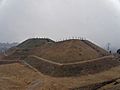
The Ōyasuba Kofun in the Tohoku region
-
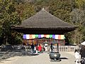
Buddhist chapel Shiramizu Amidadō
-
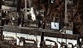
Three of the reactors at Fukushima Daiichi overheated, causing meltdowns that led to explosions, which released large amounts of radioactive material into the air.
-
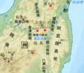
Topographic map of Fukushima Prefecture
-
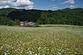
Buckwheat field in Yamato, Kitakata
-
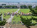
Sōma Nomaoi on July
-
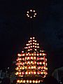
Nihonmatsu Lantern Festival on October
-
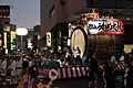
Unume Festival of Koriyama on August
-
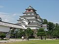
Aizuwakamatsu Castle
-
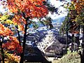
Ōuchi-juku
-
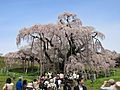
Miharu Takizakura is an ancient cherry tree in Miharu, Fukushima
-
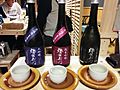
A sample set of Aizu sake
-
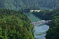
JR Tadami Line
-
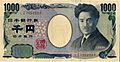
Hideyo Noguchi on the Series E 1K Yen banknote
-
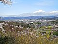
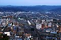
View of Fukushima Basin from Hanamiyama Park
-
Aizu basin
-
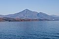
Mount Bandai and Lake Inawashiro
-
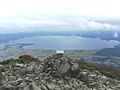
Lake Inawashiro viewed from Mount Bandai
-
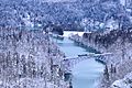
Tadami River and Tadami Line in winter
-
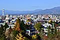
Fukushima City (May 2011)
-
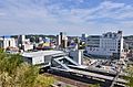
Iwaki (August 2012)
-
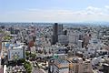
Kōriyama (May 2015)
-
Aizuwakamatsu (November 2020)


See also
 In Spanish: Prefectura de Fukushima para niños
