Tamura, Fukushima facts for kids
Quick facts for kids
Tamura
田村市
|
|||||||||||||
|---|---|---|---|---|---|---|---|---|---|---|---|---|---|

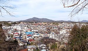
Central Tamura (2015)
|
|||||||||||||
|
|||||||||||||

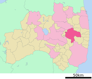
Location of Tamura in Fukushima Prefecture
|
|||||||||||||
| Country | Japan | ||||||||||||
| Region | Tōhoku | ||||||||||||
| Prefecture | Fukushima | ||||||||||||
| Area | |||||||||||||
| • Total | 458.30 km2 (176.95 sq mi) | ||||||||||||
| Population
(March 2020)
|
|||||||||||||
| • Total | 35,702 | ||||||||||||
| • Density | 77.9009/km2 (201.763/sq mi) | ||||||||||||
| Time zone | UTC+9 (Japan Standard Time) | ||||||||||||
| Phone number | 0247-82-1111 | ||||||||||||
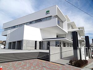
| Address | 76 Funehikimachi Funehiki aza hatazoe, Tamura-shi, Fukushima-ken 963-4393 | ||||||||||||
| Climate | Cfa | ||||||||||||
|
|||||||||||||
Tamura (田村市, Tamura-shi) is a city located in Fukushima Prefecture, Japan. As of March 1, 2020, about 35,702 people lived in the city. They lived in 12,821 households. The city's population density was about 78 people per square kilometer. Tamura covers a total area of 458.30 square kilometers (177.0 square miles).
Contents
Exploring Tamura's Location
Tamura is in the eastern part of Fukushima Prefecture. It is found in the easternmost section of the Nakadōri region. The city is located in a hilly area of the Abukuma Mountains.
Cities and Towns Near Tamura
Tamura is surrounded by several other cities and towns in Fukushima Prefecture:
Tamura's Climate and Weather
Tamura has a humid continental climate. This means it has mild summers and cold winters. Winters can also have a lot of snow. The average temperature in Tamura each year is 10.4°C (50.7°F). September is usually the wettest month, with about 1368 mm (53.9 inches) of rain per year. August is the warmest month, with temperatures around 23.1°C (73.6°F). January is the coldest month, with temperatures around -0.1°C (31.8°F).
| Climate data for Funehiki, Tamura (1991−2020 normals, extremes 1976−present) | |||||||||||||
|---|---|---|---|---|---|---|---|---|---|---|---|---|---|
| Month | Jan | Feb | Mar | Apr | May | Jun | Jul | Aug | Sep | Oct | Nov | Dec | Year |
| Record high °C (°F) | 13.4 (56.1) |
18.6 (65.5) |
21.9 (71.4) |
29.8 (85.6) |
32.8 (91.0) |
33.1 (91.6) |
34.6 (94.3) |
35.7 (96.3) |
33.5 (92.3) |
27.5 (81.5) |
23.6 (74.5) |
18.1 (64.6) |
35.7 (96.3) |
| Mean daily maximum °C (°F) | 3.4 (38.1) |
4.5 (40.1) |
8.5 (47.3) |
15.1 (59.2) |
20.7 (69.3) |
23.7 (74.7) |
27.0 (80.6) |
28.3 (82.9) |
24.0 (75.2) |
18.1 (64.6) |
12.4 (54.3) |
6.4 (43.5) |
16.0 (60.8) |
| Daily mean °C (°F) | −0.5 (31.1) |
0.0 (32.0) |
3.3 (37.9) |
9.2 (48.6) |
14.6 (58.3) |
18.4 (65.1) |
22.2 (72.0) |
23.1 (73.6) |
19.1 (66.4) |
13.1 (55.6) |
7.2 (45.0) |
2.1 (35.8) |
11.0 (51.8) |
| Mean daily minimum °C (°F) | −4.4 (24.1) |
−4.4 (24.1) |
−1.5 (29.3) |
3.4 (38.1) |
8.9 (48.0) |
13.9 (57.0) |
18.4 (65.1) |
19.2 (66.6) |
15.1 (59.2) |
8.5 (47.3) |
2.2 (36.0) |
−2.0 (28.4) |
6.4 (43.6) |
| Record low °C (°F) | −17.4 (0.7) |
−15.0 (5.0) |
−15.3 (4.5) |
−7.2 (19.0) |
−0.6 (30.9) |
3.8 (38.8) |
7.6 (45.7) |
9.1 (48.4) |
3.1 (37.6) |
−2.7 (27.1) |
−6.5 (20.3) |
−15.4 (4.3) |
−17.4 (0.7) |
| Average precipitation mm (inches) | 41.7 (1.64) |
33.7 (1.33) |
71.5 (2.81) |
84.0 (3.31) |
90.6 (3.57) |
118.4 (4.66) |
181.6 (7.15) |
149.4 (5.88) |
167.4 (6.59) |
141.3 (5.56) |
60.9 (2.40) |
40.1 (1.58) |
1,180.5 (46.48) |
| Average precipitation days (≥ 1.0 mm) | 6.6 | 5.9 | 9.2 | 9.4 | 9.7 | 11.3 | 13.8 | 11.0 | 11.5 | 9.4 | 6.7 | 6.7 | 111.2 |
| Mean monthly sunshine hours | 156.9 | 170.0 | 185.9 | 189.4 | 195.5 | 149.8 | 146.7 | 172.8 | 132.5 | 145.1 | 140.0 | 144.2 | 1,928.9 |
| Source: Japan Meteorological Agency | |||||||||||||
Tamura's Population Over Time
The number of people living in Tamura has slowly gone down over the last 60 years.
| Historical population | ||
|---|---|---|
| Year | Pop. | ±% |
| 1960 | 58,820 | — |
| 1970 | 52,926 | −10.0% |
| 1980 | 48,932 | −7.5% |
| 1990 | 46,758 | −4.4% |
| 2000 | 45,054 | −3.6% |
| 2010 | 40,422 | −10.3% |
| 2020 | 35,169 | −13.0% |
A Look at Tamura's History
The area where Tamura is today was once part of an old Japanese province called Mutsu Province. During the Edo period, much of this land was controlled by the Miharu Domain. After the Meiji Restoration, a big change in Japan's government, the area became part of Tamura District.
On April 1, 1889, several villages were created. These included Miyakoji, Tokiwa, Katasone, Takine, and Ōgoe. Over time, some of these villages grew into towns. Tokiwa became a town in 1898. Katasone became the town of Funehiki in 1934. Takine became a town in 1940, followed by Ōgoe in 1942. Finally, on March 1, 2005, these four towns and one village joined together to form the city of Tamura.
Returning Home After the Fukushima Disaster
On March 11, 2011, there was a big earthquake and tsunami in Japan. This led to a nuclear power plant accident called the Fukushima Daiichi Nuclear Disaster. Because of this, people living in the area that was once Miyakoji village had to leave their homes for safety.
On April 1, 2012, residents were allowed to visit their homes during the day. This was because cleanup work was happening to remove radiation. The order to leave was completely lifted on April 1, 2014. This meant people could move back permanently.
What Tamura's Economy is Like
Tamura's economy mainly relies on farming. Farmers in Tamura grow rice and raise cattle for beef and dairy products. They also grow many different vegetables. The area is also known for its bottled mineral water and sake, which is a type of Japanese rice wine.
Learning in Tamura: Schools
As of 2023, Tamura has eight public elementary schools and seven junior high schools. These schools are managed by the Tamura City Board of Education. There is also one high school in the city, run by the Fukushima Prefecture Board of Education.
- Fukushima Prefectural Funehiki High School
Getting Around Tamura
Train Travel
 JR East – Ban'etsu East Line
- Kanmata - Sugaya - Ōgoe - Iwaki-Tokiwa - Funehiki - Kanameta
Major Roads
 Ban-etsu Expressway
 National Route 288
 National Route 349
 National Route 399
Tamura's Global Connections
Tamura has a special relationship with a city in the United States.
 Mansfield, Ohio, United States, since October 21, 2000
Fun Places to Visit in Tamura
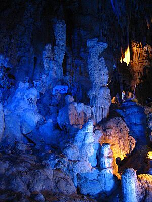
- Abukuma Limestone Caves: These are amazing caves with unique rock formations.
- Hoshi no Mura ("Village of Stars") Observatory: A great place to look at the night sky.
- Okaburaya Shrine: A traditional Japanese shrine.
- Ohtakadoyayama Transmitter: This is a tall tower that sends out a special time signal called JJY on 40 kHz. It helps keep clocks accurate.
Famous People from Tamura
- Hiroyuki Arai: A politician.
- Kōichirō Genba: A politician.
See also
 In Spanish: Tamura (Fukushima) para niños
 | Georgia Louise Harris Brown |
 | Julian Abele |
 | Norma Merrick Sklarek |
 | William Sidney Pittman |


