Katsurao, Fukushima facts for kids
Quick facts for kids
Katsurao
葛尾村
|
|||
|---|---|---|---|

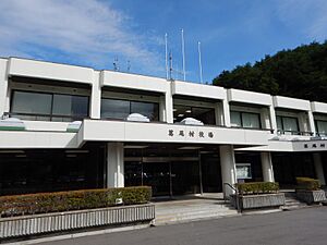
Katsurao village hall
|
|||
|
|||

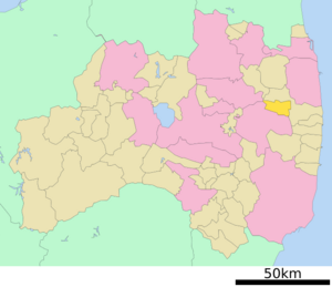
Location of Katsurao in Fukushima Prefecture
|
|||
| Country | Japan | ||
| Region | Tōhoku | ||
| Prefecture | Fukushima | ||
| District | Futaba | ||
| Area | |||
| • Total | 84.37 km2 (32.58 sq mi) | ||
| Population
(April 1, 2020)
|
|||
| • Total | 1,387 | ||
| • Density | 16.439/km2 (42.578/sq mi) | ||
| Time zone | UTC+9 (Japan Standard Time) | ||
| City symbols | |||
| • Tree | Pinus densiflora | ||
| • Flower | Azalea | ||
| • Bird | Green pheasant | ||
| Phone number | 0247-61-2850 | ||
| Address | Ochiai 16, Katsurao-mura, Futaba-gun, Fukushima-ken 979-1602 | ||
Katsurao (葛尾村, Katsurao-mura) is a small village located in Fukushima Prefecture, Japan. As of April 1, 2020, about 1,387 people lived in 475 homes. The village covers an area of about 84.37 square kilometers (32.58 sq mi).
In March 2011, everyone in Katsurao had to leave their homes. This happened because of the Fukushima Daiichi nuclear disaster. While some people have been able to return since June 2016, the number of people actually living there is much lower than before.
Contents
Geography of Katsurao
Katsurao is found in the central part of Fukushima, in a hilly area called the Abukuma Plateau. It's located in the Tōhoku region of northern Japan. The village sits at an average height of over 500 meters (1,600 ft) above sea level.
Neighboring Towns and Cities
Katsurao shares its borders with several other places in Fukushima Prefecture:
Population Changes in Katsurao
The word "demographics" means how a population changes over time. Before the nuclear disaster, the number of people living in Katsurao stayed fairly steady for 40 years. However, after the disaster, the population dropped a lot.
| Historical population | ||
|---|---|---|
| Year | Pop. | ±% |
| 1920 | 1,625 | — |
| 1930 | 2,278 | +40.2% |
| 1940 | 1,875 | −17.7% |
| 1950 | 2,816 | +50.2% |
| 1960 | 3,041 | +8.0% |
| 1970 | 2,397 | −21.2% |
| 1980 | 1,992 | −16.9% |
| 1990 | 1,866 | −6.3% |
| 2000 | 1,736 | −7.0% |
| 2010 | 1,531 | −11.8% |
| 2020 | 420 | −72.6% |
Climate and Weather in Katsurao
Katsurao has a humid climate, which means it gets a good amount of rain and has warm summers. The average temperature for the whole year is about 10.4°C (50.7°F). The village gets about 1374 mm (54 inches) of rain each year, with September being the wettest month. August is usually the warmest month, with temperatures around 23°C (73°F). January is the coldest, with temperatures around -0.7°C (30.7°F).
History of Katsurao Village
The land where Katsurao is today has a long history. In ancient times, it was part of a region called Mutsu Province. Archeologists have even found old burial mounds from the Kofun period (around 300-538 AD) in the area.
During the Nara period (710-794 AD), it was part of Iwaki Province. Later, during the Edo period (1603-1868 AD), the Sōma family ruled this area. The village of Katsurao was officially created on April 1, 1889, when Japan set up its modern system of towns and villages.
Impact of the 2011 Fukushima Nuclear Disaster
Even though Katsurao was not badly damaged by the 2011 earthquake and tsunami, it was located downwind from the Fukushima Daiichi Nuclear Power Plant. Because of the way the wind blew after the Fukushima Daiichi nuclear disaster, the entire village had to be evacuated by May 2011.
In March 2013, the government divided the village into three areas. Most of the village was expected to be safe for people to return by spring 2014. A smaller area was cleared for people to visit during the day. A larger, more restricted area remained closed. However, in March 2014, the return was delayed because radiation levels were still too high.
Finally, on June 12, 2016, the order to evacuate was lifted for about two-thirds of Katsurao. However, the mountainous parts near the neighboring town of Namie are still restricted because of high radiation.
Economy of Katsurao
In the past, the economy of Katsurao mostly depended on agriculture. This means that farming was the main way people made a living in the village.
Education in Katsurao
Before March 2011, Katsurao had one public elementary school and one public junior high school. These schools were run by the village government. Sadly, the elementary school is still closed. The village does not have a public high school.
Transportation in Katsurao
Railway Connections
Katsurao does not have any train stations for passengers. People who live there need to travel to nearby towns to catch a train.
Major Highways
- Japan National Route 399
See also
 In Spanish: Katsurao (Fukushima) para niños
 | James Van Der Zee |
 | Alma Thomas |
 | Ellis Wilson |
 | Margaret Taylor-Burroughs |


