
Kashima, Ibaraki facts for kids
Quick facts for kids
Kashima
鹿嶋市
|
|||||||||||||
|---|---|---|---|---|---|---|---|---|---|---|---|---|---|

Kashima city hall
|
|||||||||||||
|
|||||||||||||

Location of Kashima in Ibaraki Prefecture
|
|||||||||||||

Kashima
Location in Japan
|
|||||||||||||
| Country | Japan | ||||||||||||
| Region | Kantō | ||||||||||||
| Prefecture | Ibaraki | ||||||||||||
| First official recorded | 660 BC | ||||||||||||
| Town settled | April 1, 1889 | ||||||||||||
| City settled | September 1, 1995 | ||||||||||||
| Area | |||||||||||||
| • Total | 106.02 km2 (40.93 sq mi) | ||||||||||||
| Population
(July 2022)
|
|||||||||||||
| • Total | 66,098 | ||||||||||||
| • Density | 623.45/km2 (1,614.72/sq mi) | ||||||||||||
| Time zone | UTC+9 (Japan Standard Time) | ||||||||||||
| Phone number | 0299-82-2911 | ||||||||||||
| Address | 1187-1 Hirai, Kashima-shi, Ibaraki-ken 314-8655 | ||||||||||||
| Climate | Cfa | ||||||||||||
|
|||||||||||||


Kashima (鹿嶋市, Kashima-shi) is a city located in Ibaraki Prefecture, Japan. As of 2020, about 67,197 people lived there in 28,873 homes. The city covers an area of 106.02 square kilometers.
Kashima is famous for being the home of the J. League football (soccer) team, the Kashima Antlers. Their home stadium, Kashima Soccer Stadium, was even used for the 2002 FIFA World Cup. The city is also home to the Kashima Shrine, one of the oldest Shinto shrines in eastern Japan. This shrine is known as the birthplace of many important Japanese sword-fighting styles called Kenjutsu.
Contents
Geography of Kashima
Kashima is in the southeastern part of Ibaraki Prefecture. It has the Pacific Ocean to its east and Lake Kitaura to its west. The city is less than 10 kilometers wide from east to west. It is about 110 kilometers northeast of Tokyo.
Neighboring Cities and Towns
Kashima is surrounded by several other places in Ibaraki Prefecture:
- Hokota
- Itako
- Kamisu
- Namegata
Kashima's Climate
Kashima has a climate with warm summers and cool winters. Sometimes there is light snowfall. The average temperature in Kashima is about 15.0 degrees Celsius. The city gets about 1581.9 millimeters of rain each year. October is usually the wettest month. August is the warmest month, with temperatures around 25.6 degrees Celsius. January is the coldest, with temperatures around 4.7 degrees Celsius.
| Climate data for Kashima (1991−2020 normals, extremes 1978−present) | |||||||||||||
|---|---|---|---|---|---|---|---|---|---|---|---|---|---|
| Month | Jan | Feb | Mar | Apr | May | Jun | Jul | Aug | Sep | Oct | Nov | Dec | Year |
| Record high °C (°F) | 19.3 (66.7) |
23.6 (74.5) |
24.3 (75.7) |
29.4 (84.9) |
32.6 (90.7) |
33.6 (92.5) |
36.6 (97.9) |
36.1 (97.0) |
36.4 (97.5) |
32.8 (91.0) |
25.6 (78.1) |
23.8 (74.8) |
36.6 (97.9) |
| Mean daily maximum °C (°F) | 9.4 (48.9) |
9.9 (49.8) |
12.8 (55.0) |
17.5 (63.5) |
21.7 (71.1) |
24.2 (75.6) |
28.3 (82.9) |
29.9 (85.8) |
26.3 (79.3) |
21.3 (70.3) |
16.6 (61.9) |
11.8 (53.2) |
19.1 (66.4) |
| Daily mean °C (°F) | 4.7 (40.5) |
5.4 (41.7) |
8.5 (47.3) |
13.1 (55.6) |
17.3 (63.1) |
20.3 (68.5) |
24.1 (75.4) |
25.6 (78.1) |
22.7 (72.9) |
17.9 (64.2) |
12.5 (54.5) |
7.2 (45.0) |
14.9 (58.9) |
| Mean daily minimum °C (°F) | 0.3 (32.5) |
1.0 (33.8) |
4.2 (39.6) |
9.0 (48.2) |
13.6 (56.5) |
17.3 (63.1) |
21.0 (69.8) |
22.7 (72.9) |
19.9 (67.8) |
14.7 (58.5) |
8.5 (47.3) |
2.9 (37.2) |
11.3 (52.3) |
| Record low °C (°F) | −5.8 (21.6) |
−6.0 (21.2) |
−3.7 (25.3) |
−0.7 (30.7) |
5.1 (41.2) |
9.8 (49.6) |
13.8 (56.8) |
15.8 (60.4) |
10.5 (50.9) |
4.7 (40.5) |
0.7 (33.3) |
−3.8 (25.2) |
−6.0 (21.2) |
| Average precipitation mm (inches) | 88.2 (3.47) |
72.1 (2.84) |
129.8 (5.11) |
123.3 (4.85) |
132.7 (5.22) |
145.4 (5.72) |
134.8 (5.31) |
102.3 (4.03) |
210.9 (8.30) |
273.7 (10.78) |
105.8 (4.17) |
66.6 (2.62) |
1,581.9 (62.28) |
| Average precipitation days (≥ 1.0 mm) | 6.7 | 7.3 | 11.2 | 10.7 | 10.7 | 11.6 | 10.1 | 7.3 | 11.4 | 11.8 | 8.5 | 6.7 | 114 |
| Mean monthly sunshine hours | 189.5 | 173.3 | 176.6 | 187.4 | 184.2 | 140.1 | 165.9 | 204.3 | 149.5 | 136.8 | 145.2 | 168.1 | 2,020.8 |
| Source: Japan Meteorological Agency | |||||||||||||
Kashima's Population Growth
The number of people living in Kashima has grown a lot over time. Recently, the population has stayed about the same after a long period of increasing.
| Historical population | ||
|---|---|---|
| Year | Pop. | ±% |
| 1920 | 18,922 | — |
| 1930 | 20,284 | +7.2% |
| 1940 | 21,701 | +7.0% |
| 1950 | 27,481 | +26.6% |
| 1960 | 26,811 | −2.4% |
| 1970 | 34,700 | +29.4% |
| 1980 | 51,355 | +48.0% |
| 1990 | 59,092 | +15.1% |
| 2000 | 62,287 | +5.4% |
| 2010 | 66,093 | +6.1% |
| 2020 | 66,950 | +1.3% |
History of Kashima City
Kashima grew around the Kashima Shrine during the Nara period (710-794 AD). The town of Kashima was officially created on April 1, 1889. Later, in 1954, Kashima joined with nearby villages like Takamatsu and Toyosu. On September 1, 1995, Kashima merged with the village of Ono and officially became a city.
Kashima's Economy and Industries
Kashima is a very important industrial area. It is the main city of the Kashima Industrial Zone. This zone has a large industrial park with about 1500 factories. Many of these factories produce petrochemical products and steel. The Japanese government started developing this industrial zone in 1963. Most of the development was finished by 1973. Farming and commercial fishing are also important parts of Kashima's economy.
Education in Kashima
Kashima has many schools for students. The city government runs 12 public elementary schools and five public middle schools. The Ibaraki Prefectural Board of Education operates one public high school. There are also one private middle school and two private high schools in Kashima.
Sports in Kashima
The most famous sports team in Kashima is the Kashima Antlers. They are a professional football (soccer) club that plays in Japan's top league, the J. League.
Transportation in Kashima
Kashima has different ways to get around, including trains, highways, and a port.
Railway Lines
 JR East – Kashima Line
- Kashimajingū
- Kashima Soccer Stadium
 Kashima Rinkai Railway Ōarai Kashima Line
- Kashimanada
- Kashima-Ōno
- Chōjagahamashiosaihamanasukōenmae
- Kōyadai
- Kashima Soccer Stadium
- Kashimajingū
Major Highways
 National Route 51
 National Route 124
Seaport
- Port of Kashima is an important port for trade and industry.
Sister Cities of Kashima
Kashima has special friendships with cities in other countries. These are called "sister cities."
 Seogwipo, Jeju Province, Republic of Korea, since November 2003
 Yancheng, Jiangsu Province, China, since November 2008
Local Attractions to Visit
- Kashima Shrine is a very old and important Shinto shrine.

Notable People from Kashima
Many interesting people have come from Kashima, including:
- Tsukahara Bokuden, a famous swordsman
- Harumi Hanayagi, an actress
- Yuichi Nemoto, a former soccer player
- Yasutaka Nomoto, a soccer player
- Ryuta Sasaki, a former soccer player
- Hitoshi Sogahata, a soccer player
- Juri Takahashi, a singer and dancer, known as a K-pop idol and former J-pop idol. She is a member of the K-pop girl group Rocket Punch.
Gallery
-
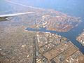
Port of Kashima with Kamisu in the foreground
-
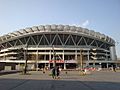
Kashima Soccer Stadium
-
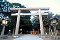
The Torii Gate at the entrance of Kashima Shrine
-
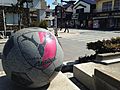
Monument for Kashima Antlers near Kashima Shrine


See also
 In Spanish: Kashima (Ibaraki) para niños
