
Saitama (city) facts for kids
Quick facts for kids
Saitama
さいたま市
|
|||||||||||
|---|---|---|---|---|---|---|---|---|---|---|---|
| Saitama City | |||||||||||
![From top left: Saitama Stadium 2002, Urawa Parco [ja], Gyokuzouin [ja], Hikawa Shrine, Saitama New Urban Center, Saitama Super Arena, Musashi-Urawa Station](/Image:Saitama_city_montage.jpg)
From top left: Saitama Stadium 2002, Urawa Parco, Gyokuzouin, Hikawa Shrine, Saitama New Urban Center, Saitama Super Arena, Musashi-Urawa Station
|
|||||||||||
|
|||||||||||

Location of Saitama in Saitama Prefecture
|
|||||||||||

Saitama
Location in Japan
|
|||||||||||
| Country | Japan | ||||||||||
| Region | Kantō | ||||||||||
| Prefecture | Saitama | ||||||||||
| Area | |||||||||||
| • Total | 217.43 km2 (83.95 sq mi) | ||||||||||
| Population
(March 1, 2021)
|
|||||||||||
| • Total | 1,324,854 | ||||||||||
| • Density | 6,093.24/km2 (15,781.4/sq mi) | ||||||||||
| Time zone | UTC+9 (Japan Standard Time) | ||||||||||
| Phone number | 048-829-1111 | ||||||||||
| Address | 6-4-4 Tokiwa, Urawa-ku, Saitama-shi, Saitama-ken 330-9588 | ||||||||||
| Climate | Cfa | ||||||||||
|
|||||||||||


Saitama (さいたま市 (Saitama-shi)) is the capital city of Saitama Prefecture in Japan. It is also the largest city in the prefecture. Saitama was created by combining four older cities: Urawa, Ōmiya, Yono, and Iwatsuki.
Saitama is a special type of city in Japan called a "city designated by government ordinance." This means it has more powers and responsibilities than a regular city. As of February 1, 2021, about 1,324,854 people live in Saitama. The city covers an area of about 217.43 square kilometers (83.95 square miles).
Contents
- What's in a Name? The Story of Saitama
- Where is Saitama?
- Saitama's Population Growth
- How Saitama is Divided: Wards
- A Brief History of Saitama
- Saitama's Economy and Industries
- How Land is Used in Saitama
- Getting Around Saitama: Transportation
- Learning and Sports in Saitama
- Sister Cities Around the World
- Fun Places to Visit in Saitama
- Images for kids
- See also
What's in a Name? The Story of Saitama
The name Saitama comes from an old area called Sakitama District. This district was in what is now the city of Gyōda. The name Sakitama is very old. It was even mentioned in a famous collection of poems from the 8th century called Man'yōshū. Over many years, the way people said "Sakitama" changed, and it became "Saitama."
When the cities of Urawa, Ōmiya, and Yono joined together, they needed a new name for their new capital city. They decided to change the name of the prefecture, "Saitama" (埼玉県), from its traditional Japanese characters (kanji) to a simpler writing style called hiragana. This is how Saitama City (さいたま市) got its name. It is the only capital city in Japan that always writes its name using hiragana.
Interestingly, when people were asked to vote on the new name, "Saitama" written in hiragana (さいたま市) actually came in second place. Most people voted for "Saitama" written in kanji (埼玉市). But government officials chose the hiragana version anyway. The third most popular choice was Ōmiya (大宮市).
Where is Saitama?
Saitama is located about 20 to 30 kilometers (12 to 19 miles) north of central Tokyo. It sits in the middle of the Kantō Plain, which is a large flat area. The city is in the southeast part of Saitama Prefecture.
The land in Saitama is mostly flat, with lowlands and plateaus. Most of the city is less than 20 meters (66 feet) above sea level. There are no mountains or big hills inside the city. The western part of Saitama is a lowland area. It was formed by the Arakawa River and other smaller rivers. The rest of the city is mostly on the Ōmiya Plateau, which runs from north to south. Several major rivers flow through this area, generally running south.
Neighboring Cities and Towns
Saitama is surrounded by several other cities and towns in Saitama Prefecture. These include:
- Ageo
- Asaka
- Fujimi
- Hasuda
- Kasukabe
- Kawagoe
- Kawaguchi
- Koshigaya
- Shiki
- Shiraoka
- Toda
- Warabi
Saitama's Climate
Saitama has a humid subtropical climate. This means it has warm summers and cool winters. There is usually little to no snowfall. The average temperature in Saitama for the whole year is about 15.2°C (59.4°F).
The city gets about 1371.3 millimeters (54 inches) of rain each year. September is usually the wettest month. August is the warmest month, with an average temperature of about 27.0°C (80.6°F). January is the coldest month, with an average of about 3.9°C (39.0°F).
| Climate data for Saitama (1991−2020 normals, extremes 1976−present) | |||||||||||||
|---|---|---|---|---|---|---|---|---|---|---|---|---|---|
| Month | Jan | Feb | Mar | Apr | May | Jun | Jul | Aug | Sep | Oct | Nov | Dec | Year |
| Record high °C (°F) | 18.7 (65.7) |
25.5 (77.9) |
26.9 (80.4) |
31.2 (88.2) |
34.2 (93.6) |
38.0 (100.4) |
39.3 (102.7) |
38.7 (101.7) |
37.4 (99.3) |
33.1 (91.6) |
26.0 (78.8) |
25.1 (77.2) |
39.3 (102.7) |
| Mean daily maximum °C (°F) | 9.4 (48.9) |
10.3 (50.5) |
13.7 (56.7) |
19.2 (66.6) |
23.8 (74.8) |
26.5 (79.7) |
30.5 (86.9) |
31.8 (89.2) |
27.7 (81.9) |
21.9 (71.4) |
16.5 (61.7) |
11.7 (53.1) |
20.3 (68.5) |
| Daily mean °C (°F) | 3.9 (39.0) |
4.9 (40.8) |
8.4 (47.1) |
13.7 (56.7) |
18.6 (65.5) |
22.0 (71.6) |
25.9 (78.6) |
27.0 (80.6) |
23.2 (73.8) |
17.5 (63.5) |
11.4 (52.5) |
6.2 (43.2) |
15.2 (59.4) |
| Mean daily minimum °C (°F) | −1.1 (30.0) |
−0.2 (31.6) |
3.3 (37.9) |
8.4 (47.1) |
13.9 (57.0) |
18.3 (64.9) |
22.2 (72.0) |
23.2 (73.8) |
19.5 (67.1) |
13.5 (56.3) |
6.8 (44.2) |
1.2 (34.2) |
10.8 (51.4) |
| Record low °C (°F) | −9.8 (14.4) |
−8.8 (16.2) |
−5.0 (23.0) |
−2.0 (28.4) |
4.8 (40.6) |
11.5 (52.7) |
14.7 (58.5) |
16.3 (61.3) |
9.5 (49.1) |
3.6 (38.5) |
−2.4 (27.7) |
−6.7 (19.9) |
−9.8 (14.4) |
| Average precipitation mm (inches) | 42.4 (1.67) |
39.6 (1.56) |
88.0 (3.46) |
101.9 (4.01) |
121.4 (4.78) |
144.8 (5.70) |
148.0 (5.83) |
164.0 (6.46) |
202.8 (7.98) |
196.8 (7.75) |
70.9 (2.79) |
45.2 (1.78) |
1,371.3 (53.99) |
| Average precipitation days (≥ 1.0 mm) | 3.8 | 4.6 | 8.7 | 9.0 | 10.0 | 11.6 | 11.8 | 8.8 | 10.8 | 10.0 | 6.7 | 4.4 | 100.8 |
| Average dew point °C (°F) | −5 (23) |
−4 (25) |
1 (34) |
8 (46) |
13 (55) |
18 (64) |
22 (72) |
23 (73) |
19 (66) |
12 (54) |
6 (43) |
−1 (30) |
9 (49) |
| Mean monthly sunshine hours | 201.4 | 186.4 | 186.6 | 187.1 | 185.3 | 128.4 | 152.5 | 181.9 | 135.6 | 135.1 | 156.6 | 181.1 | 2,018 |
| Source 1: Japan Meteorological Agency | |||||||||||||
| Source 2: Time and Date (dewpoints, 1985-2015) | |||||||||||||
Saitama's Population Growth
The number of people living in Saitama has grown steadily over the last 100 years. This information comes from Japanese census data.
| Historical population | ||||||||||||||||||||||||||||||||||||||||||||||||||||||||||||||||||||||
|---|---|---|---|---|---|---|---|---|---|---|---|---|---|---|---|---|---|---|---|---|---|---|---|---|---|---|---|---|---|---|---|---|---|---|---|---|---|---|---|---|---|---|---|---|---|---|---|---|---|---|---|---|---|---|---|---|---|---|---|---|---|---|---|---|---|---|---|---|---|---|
|
|
|||||||||||||||||||||||||||||||||||||||||||||||||||||||||||||||||||||
How Saitama is Divided: Wards
Saitama is divided into ten smaller areas called wards (ku). Each ward was given an official color in April 2005.
| Wards of Saitama | |||||
|---|---|---|---|---|---|
| Place name | Map of Saitama | ||||
| Rōmaji | Kanji | Color | Area (km2) | ||
| 1 | Chūō-ku | 中央区 | ■ (rose red) | 8.39 | |
| 2 | Iwatsuki-ku | 岩槻区 | ■ (ochre) | 49.17 | |
| 3 | Kita-ku | 北区 | ■ (dark green) | 16.86 | |
| 4 | Midori-ku | 緑区 | ■ (green) | 26.44 | |
| 5 | Minami-ku | 南区 | ■ (lemon yellow) | 13.82 | |
| 6 | Minuma-ku | 見沼区 | ■ (sky blue) | 30.69 | |
| 7 | Nishi-ku | 西区 | ■ (blue) | 29.12 | |
| 8 | Ōmiya-ku | 大宮区 | ■ (orange) | 12.80 | |
| 9 | Sakura-ku | 桜区 | ■ (cherry blossom pink) | 18.64 | |
| 10 | Urawa-ku | 浦和区 | ■ (red) - administrative center | 11.51 | |

A Brief History of Saitama

Saitama City was officially created on May 1, 2001. It became a special "government ordinance" city on April 1, 2003. This means it gained more local power.
Before 2001, the areas of Urawa, Ōmiya, and Yono were separate cities. You can learn more about their past here:
- Urawa-ku, Saitama
- Ōmiya-ku, Saitama
- Yono, Saitama
On April 1, 2005, Saitama grew even bigger. It took in the city of Iwatsuki, which is to its east. Iwatsuki then became a new ward called Iwatsuki-ku.
Saitama's Economy and Industries
Saitama's economy is mostly based on business and trade. The city is a major business center for the greater Tokyo area. It also serves as a hub for Saitama Prefecture and other parts of Japan.
Many different types of products are made in Saitama. These include cars, food, optical devices, and medicines. For example, Calsonic Kansei, a big car parts company, has its main office here. Iwatsuki is especially known for making traditional Japanese hinamatsuri dolls and fancy kabuto (samurai helmets).
How Land is Used in Saitama
The main government and office buildings of Saitama are in Urawa Ward, near Urawa Station. The main shopping, business, and transportation center is in Omiya Ward, around Omiya Station.
Saitama City is about 20 to 35 km (12 to 22 miles) from central Tokyo. Many people who live in Saitama travel to Tokyo for work or school. This makes Saitama a "bed town" for the Tokyo area. In 2010, about 23.5% of Saitama's commuters traveled to Tokyo.
Some areas, like the former cities of Urawa and Omiya, have become important business centers. In 2000, the Saitama New Urban Center opened. Many government offices moved there from Tokyo. Areas closer to Tokyo, like Minami ward and Midori ward, have more people living in them. This is because they are popular places for people who commute to Tokyo.
Major train stations like Urawa, Omiya, and Saitama-Shintoshin are central to the city. They have many shops, businesses, and government services. Omiya Station is a very busy train station. All the fast Shinkansen bullet trains stop there. The Urawa area is known for its good schools, like Saitama University. It is also a nice place to live.
Getting Around Saitama: Transportation

Saitama is a big transportation hub for both people and goods traveling by train. Ōmiya Station is the biggest train hub in Saitama Prefecture. It is part of Japan's Shinkansen high-speed train network.
The closest big airports are Haneda Airport and Narita International Airport. Both are about two hours away by public transport. Honda Airport in Okegawa is for smaller planes and does not have regular flights.
Train Stations in Saitama
Saitama has many train lines that connect it to other parts of Japan.
- Shinkansen (Bullet Trains): Tōhoku, Akita, Yamagata, Jōetsu and Hokuriku Shinkansen all stop at:
-
- Ōmiya
- Local Lines:
-
- ■ Utsunomiya Line: Urawa - Saitama-Shintoshin - Ōmiya - Toro - Higashi-Ōmiya
- ■ Takasaki Line: Ōmiya - Miyahara (This line often connects with the Utsunomiya Line)
- ■ Keihin-Tōhoku Line: Minami-Urawa - Urawa - Kita-Urawa - Yono - Saitama-Shintoshin - Ōmiya
- ■ Saikyō Line: Musashi-Urawa - Naka-Urawa - Minami-Yono - Yonohommachi - Kita-Yono - Ōmiya
- ■ Musashino Line: Nishi-Urawa - Musashi-Urawa - Minami-Urawa - Higashi-Urawa
- ■ Kawagoe Line: Ōmiya - Nisshin - Nishi-Ōmiya - Sashiōgi
 Saitama Rapid Railway Line
-
- Urawa Misono
 Tōbu Railway - Tōbu Urban Park Line
-
- Ōmiya - Kita-Ōmiya - Ōmiya-kōen - Ōwada - Nanasato - Iwatsuki - Higashi-Iwatsuki
 Saitama New Urban Transit ("New Shuttle") - Ina Line
-
- Ōmiya - Tetsudō-Hakubutsukan - Kamonomiya - Higashi-Miyahara - Konba - Yoshinohara
Major Roads and Highways
Several important highways and routes pass through Saitama:
 Tōhoku Expressway
 Tokyo Gaikan Expressway (Tokyo Gaikan Expressway)
 Shuto Expressway Ōmiya Route
 Shuto Expressway Saitama Shintoshin Route
 National Route 16
 National Route 17
 National Route 122
 National Route 298
 National Route 463
Learning and Sports in Saitama
Universities and Colleges
Saitama is home to many universities and colleges, offering various study programs:
- Mejiro University
- Nihon University Faculty of Law
- Nippon Institute of Technology
- The Open University of Japan Omiya Study Center
- Saitama University
- Shibaura Institute of Technology
- University of Human Arts and Sciences
- Urawa University
- Kokusai Gakuin Saitama Junior College
- Urawa University Junior College
High Schools
The city operates several municipal high schools:
- Saitama Municipal Ohmiya International Secondary School
- Saitama Municipal Omiya Kita High School
- Saitama Municipal Urawa Junior and Senior High School
- Saitama Municipal Urawa Minami High School
Sports Teams and Events
Saitama is a big city for sports! It hosted games for the official 2006 Basketball World Championship.
The city has two professional football teams in the J. League:
Saitama is also home to the Saitama Broncos, a professional Basketball team in the Japan Professional Basketball League.
- Saitama Seibu Lions is a professional baseball team.
- NJPW Dojo is a training center for professional wrestling.
Since 2013, Saitama has hosted the Saitama Criterium. This is a cycling race sponsored by the famous Tour de France. It happens every year in late October.
Sister Cities Around the World
Saitama has seven sister cities in different countries. These partnerships help build friendships and understanding between cities.
 Toluca, State of Mexico, Mexico, since 1979
 Zhengzhou, Henan, China, since 1981
 Hamilton, New Zealand, since 1984
 Richmond, Virginia, United States, since 1994
 Nanaimo, British Columbia, Canada, since 1996
- Pittsburgh, Pennsylvania, United States, since 1998
 Leipzig, Saxony, Germany, since 2020
Fun Places to Visit in Saitama

Saitama has many interesting places to visit, from parks to museums:
- Akigase Park
- Besshonuma Park
- Hikawa Shrine - A beautiful and historic shrine.
- Minuma Rice Paddies - A scenic area with traditional rice fields.
- Minuma Tsūsen-bori
- Ōmiya Bonsai Village - A famous place to see amazing miniature trees.
- Railway Museum - A popular museum about trains and railways.
- Saitama Museum of Modern Art - A place to see modern art.
- Saitama New Urban Center - A modern area with offices and event spaces.
- Saitama Stadium 2002 - A large stadium used for football matches.
- Saitama Super Arena - A big indoor arena for concerts and sports.
Images for kids
-
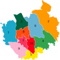
A map of Saitama's Wards
-
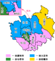
Pink: former Urawa
Blue: former Ōmiya
Green: former Yono
Yellow: former Iwatsuki -
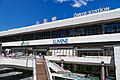
Omiya Station, a major railway hub in Saitama
-
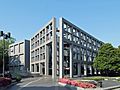
Saitama Museum of Modern Art
See also
 In Spanish: Saitama (Saitama) para niños
