Kantō Plain facts for kids

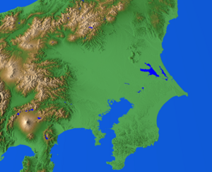
The Kantō Plain (which is Kantō heiya in Japanese) is the biggest flat area of land in Japan. It's located in the central part of Honshu island, in the Kantō region. This huge plain covers about 17,000 square kilometers. That's more than half of the Kantō region! Many important cities and prefectures are on this plain, including Tokyo, Saitama Prefecture, Kanagawa Prefecture, Chiba Prefecture, Gunma Prefecture, Tochigi Prefecture, and Ibaraki Prefecture.
Contents
Exploring the Kantō Plain's Geography
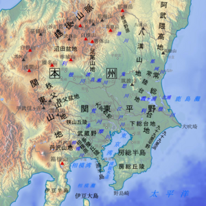
The Kantō Plain has clear natural borders. To the north, it meets the Abukuma Highlands and other mountain ranges. The western side is bordered by the Kantō Mountains. To the south, you'll find the Bōsō Peninsula, the Miura Hills, Tokyo Bay, and Sagami Bay. The eastern side is defined by the Kashima Sea and Kujūkuri Beach.
Most of the rivers here start in the mountains to the north or west. They flow east or southeast, eventually reaching the Pacific Ocean, Tokyo Bay, or Sagami Bay.
Major Rivers of the Plain
The Tone River flows through the central part of the plain. It's a very important river because its drainage area is the largest in Japan. This means it collects water from a huge amount of land, about 16,840 square kilometers!
Other important rivers include:
- The Watarase River
- The Kinu River
- The Kokai River
- The Naka River
- The Kuji River (in the northern part)
- The Arakawa River
- The Tama River
- The Sagami River (in the southern part)
All these rivers help create the flat, low-lying areas of the Kantō Plain.
Understanding the Plateaus
A big part of the Kantō Plain is made up of several plateaus. Plateaus are like large, flat areas of land that are higher than the land around them. Some of the main plateaus here are:
- The Ōmiya Plateau
- The Musashino Plateau
- The Sagamino Plateau
- The Jōsō Plateau
- The Shimōsa Plateau
These large plateaus are often separated by shallow river valleys. A cool fact about these plateaus is that their surfaces are covered with a thick layer of loam. This loam is a special kind of soil that comes from volcanoes! Volcanic ash from nearby volcanoes like Mounts Asama, Haruna, and Akagi (to the north) and Mounts Hakone and Fuji (to the southwest) settled on these plateaus over time.
The Musashino Plateau
The Musashino Plateau is the largest of these plateaus. It stretches from the western edge of Ōme all the way to the eastern edge of Yamanote. Its height slowly goes down from west to east. It's about 190 meters high in Ōme and about 20 meters high in Yamanote.
Hills in the Plain
There are also hills in the Kantō Plain. These hills are usually between 100 and 200 meters above sea level. Examples include the Sayama Hills and the Tama Hills. Hills on the western edge, like the Hiki Hills and Koma Hills, also reach about 200 meters high.
The entire plain, including its plateaus and hills, is slightly tilted. It forms a kind of basin, with the lowest point around the Tone River and Tokyo Bay. The land is still slowly sinking in the middle due to natural tectonic movements.
Major Earthquake in 1923
Sadly, a very strong earthquake hit the Kantō Plain on September 1, 1923. It caused a lot of damage, and many people lost their lives.
How the Kantō Plain Was Formed
The Kantō Plain was shaped by a long process called the "Kanto basin-forming movement." This movement has been happening since the Neogene period, which was millions of years ago! This process caused sediment (like sand and mud) to build up very thickly in the center of what is now the Kantō Plain. At the same time, the mountains around it were pushed upwards.
Because of this, the sediment from the surrounding mountains piled up to be as thick as 3,000 meters! This thick layer then lifted up to form the many hills and plateaus we see today. Scientists believe there are big tectonic lines deep below the plain, but it's hard to find them because of the thick, soft layers of sediment on top.
Over thousands of years, rivers also brought more sediment, creating new land. The plain looked almost the same as it does today by the time of the Late Jomon to Early Yayoi Period, which was more than 3,000 years ago.
Climate of the Kantō Plain
The Kantō Plain has a temperate climate, which means it has four distinct seasons. It's influenced by the Pacific Ocean. Winters are cold, and summers are hot. The further you go inland, away from the coast, the bigger the difference in temperature between summer and winter, and even between day and night.
The area gets a good amount of sunshine, especially in the northern parts. The Kuroshio Current (also known as the Black Current), which is a warm ocean current, flows along the coast. This makes the climate milder, especially in the southern parts of the plain.
Summer Weather
In summer, there's a lot of rain because of the rainy season front and frequent typhoons. Thunderclouds often form in the mountains to the north and west in the morning. By early afternoon, these clouds move over the plains, often causing evening showers and thunderstorms.
Sometimes, a weather system called the Okhotsk anticyclone brings cool, northeasterly winds. These winds can cause cooler summers, where temperatures don't rise as much.
Winter Weather
In winter, winds from the Sea of Japan are usually blocked by the Mikuni Mountains. This means most of the moisture falls as snow in the mountains to the north. The winds that reach the Kantō Plain have lost their moisture and blow as strong, dry gales. You might hear about winds like Akagi Orosi in Gunma Prefecture or Tsukuba Orosi in Ibaraki Prefecture.
While snowfall has been decreasing over the years, the plain still gets about 10–20 cm of snow a few times each winter.
Temperatures Throughout the Year
Throughout the year, especially in inland areas, the Kantō Plain can get very cold at night due to something called radiative cooling. This happens on clear nights with north winds, and temperatures can drop to about -5 degrees Celsius in winter before sunrise.
Even on very cold mornings, the daytime temperature usually rises to about 7 to 10 degrees Celsius on sunny days. If there are strong, dry north winds, it can feel even colder than the actual temperature.
In central Tokyo, the lowest temperatures are often higher than in the surrounding areas. This is because of the "heat island effect," where cities tend to be warmer than rural areas. Places like Kumagaya tend to get hotter because they are inland. They also experience the foehn phenomenon, where wind warms up as it blows down after crossing mountains. The sea breeze also warms up as it passes through central Tokyo before reaching Kumagaya.
See also
 In Spanish: Llanura de Kantō para niños
 | Aaron Henry |
 | T. R. M. Howard |
 | Jesse Jackson |


