
St Budeaux facts for kids
Quick facts for kids St Budeaux |
|
|---|---|
 St Paul's Catholic Church |
|

St Budeaux
|
|
| Population | 13,369 (2011) |
| OS grid reference | SX4458 |
| Unitary authority | |
| Ceremonial county | |
| Region | |
| Country | England |
| Sovereign state | United Kingdom |
| Post town | PLYMOUTH |
| Postcode district | PL5 |
| Dialling code | 01752 |
| Police | Devon and Cornwall |
| Fire | Devon and Somerset |
| Ambulance | South Western |
| EU Parliament | South West England |
| UK Parliament |
|
St Budeaux is a lively area and ward located in the northwest part of Plymouth, a city in the English county of Devon. It's a place with a long and interesting history, from its early beginnings as a small settlement to becoming a busy part of modern Plymouth.
Contents
Discovering St Budeaux's Ancient Roots
The name St Budeaux comes from Saint Budoc, who was a Bishop of Dol in Brittany. Around the year 480, it's believed that Saint Budoc started a settlement here and built a small church. This early church eventually led to a stronger stone church, also dedicated to Saint Budoc. It was built just before the Norman conquest of England in 1066.
The village was even mentioned in William the Conqueror's Domesday Book in 1086. Back then, it was called Bucheside. It was quite valuable, worth about 30 shillings, which was much more than nearby areas. Over hundreds of years, its name changed many times, from Bodekishide to Budeokshed. The name St Budeaux we use today is a more fancy, French-sounding version.
St Budeaux: From the 15th to 18th Centuries

In 1482, the Bishop of Exeter decided that St Budeaux should become its own separate parish. This meant it had its own church and local area to manage. As the population grew in the early Tudor period, people needed a bigger church. A new, larger church was finished in 1563. In 1804, it was described as a simple but beautiful building.
In 1518, Sir Francis Drake received his coat of arms, a special symbol for his family, for helping his country. It had the words "SIC PARVIS MAGNA" written on it, which means "Greatness from small beginnings." Later, on July 4, 1569, Sir Francis Drake married a local woman named Mary Newman in St Budeaux. Lady Drake was buried there in 1582.
During the English Civil War, Plymouth and the villages around it, including St Budeaux, supported the Parliamentarian side. They promised to fight for their cause. The Royalist forces from Cornwall, just across the water, took control of St Budeaux. They used the church as a garrison, which is a place where soldiers live. The war badly damaged the church, and it wasn't repaired until 1655.
St Budeaux's Growth in the 19th Century
In 1805, a Gunpowder Works was built next to Kinterbury Creek. Its job was to fix gunpowder that had become damp or damaged from ships. Workers would carefully unpack the powder, check it, and then dry it in special ovens. After drying, it was stored in a magazine until it was ready to be used again.
Later, in 1852, a new and much larger gunpowder storage area was opened at Bull Point, near the Works. It could hold up to 40,000 barrels of powder. This site, called RNAD Bull Point, closed in 2009 but is still owned by the MoD. It includes 48 buildings that are protected because of their history.
In 1860, the War Department bought a lot of land in St Budeaux. This happened because Prime Minister Lord Palmerston was worried about France, which was then led by Napoleon III. His fears were a bit over the top, and the military forts built around Plymouth because of this fear became known as "Palmerston's Follies." However, this activity led to more people moving to the area and changed its feel. Agaton Fort, which is only about 480 yards north of St Budeaux, was finished in 1871.
In 1890, Edmund Tolley became the first railway station master in St Budeaux. He was a respected person in the community.
By the 1890s, St Budeaux had grown into a self-contained village, especially in Lower St Budeaux. Much of this growth was encouraged by General John Trelawney. He inherited a lot of land in St Budeaux in 1883. The village was already growing because of the Royal Albert Bridge and better roads. New railway stations also opened: St Budeaux Victoria Road (London and South Western Railway) and Ferry Road (Great Western Railway).
In the next ten years, General Trelawney built houses and roads. He also sold land to Joseph Stribling, who built the Trelawny Hotel in 1895. This hotel was special because it was the first building in St Budeaux to have electricity. Many new shops also opened around this time.
In 1899, St Budeaux joined with the town of Devonport. This led to many improvements in local roads and transport. A new railway bridge was built, allowing the Devonport and District Tramway Company to offer good service from Devonport, through St Budeaux, to Saltash Passage. This helped connect Plymouth to Cornwall.
St Budeaux in the 20th Century
After World War I in 1918, St Budeaux and other nearby towns became part of the city of Plymouth. During this time, there was a lot of building and demolition. Six more churches were built in the parish. Much of this work was done by the Plymouth Corporation, which often bought land from big landowners and then developed new facilities there. The vicar of St Budeaux church at the time, Reverend T. A. Hancock, was very upset by these actions and protested in the 1930s, but it didn't change anything.
Many homes in the area were bombed during World War II. After the war, a lot of rebuilding happened, which led to a rapid increase in new houses.

Modern St Budeaux Today
Today, St Budeaux is home to several churches: a Catholic church, a Methodist church, a Baptist church, and two Church of England churches (St Budeaux and St Boniface). The area also has a public library, three pubs, and four primary schools, including St Budeaux Church of England Primary Academy.
St Budeaux has two railway stations: St Budeaux Ferry Road and St Budeaux Victoria Road. While there isn't a secondary school directly in the village, most older students attend Marine Academy Plymouth in the nearby area of King's Tamerton. Some also travel by bus to grammar schools or other community colleges. Most of the main shops, including a KFC restaurant, are located in St Budeaux Square, which is next to Wolseley Road.
Exploring Agaton Fort


Agaton Fort is part of the defences of Plymouth in the northeast. Work on this fort began in 1863 on a hill near the small village of Agaton, within the St Budeaux parish. It's a five-sided fort, designed to hold fifteen large 7-inch guns. These guns could help protect the nearby Ernesettle Fort and Knowle Battery.
The first company hired to build the fort failed in 1866, so Royal Engineers finished the work in 1871. However, only three of the 7-inch guns were ever put in place. Five smaller 64-pounder guns were also added for close protection. The fort was also protected by a dry ditch and three caponiers, which are covered passages for defense.
The fort's guns were removed in the 1890s, but it continued to be used by the military during both World Wars. Today, it serves as a VOSA Test Station and is a Scheduled monument, meaning it's a nationally important historical site.
In March 2020, it was announced that Agaton Fort would be used as a temporary mortuary facility. This was in response to the 2019-20 coronavirus pandemic.
Images for kids
-

St Paul's Catholic Church
-
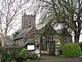
The Parish Church of St Budeaux
-
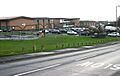
Tamarside Community College
-
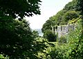
The western wall of Agaton Fort
-
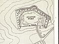
Plan of Agaton Fort
