
Knettishall Heath facts for kids
| Site of Special Scientific Interest | |
 |
|
| Area of Search | Suffolk |
|---|---|
| Interest | Biological |
| Area | 91.7 hectares |
| Notification | 1984 |
| Location map | Magic Map |
Knettishall Heath is a special nature spot in Suffolk, England. It's a big area, about 91.7 hectares (that's like 226 football fields!). A larger part, 176 hectares, is a nature reserve looked after by the Suffolk Wildlife Trust.
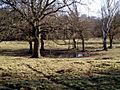
Even though it's called a "heath," it's actually a mix of different places! You'll find woodlands, meadows by the river, and open heathland. This makes it a home for many different plants and animals.
Contents
Exploring Knettishall Heath
This area has open heathland and grassy spots. The soil is a bit acidic, which means certain plants love to grow here. You can also find some woods and wet, boggy areas.
Plants of the Heath
Look out for cool heathland plants like sheep's sorrel, tormentil, harebell, and ling. In the wet parts, you might see water mint and yellow iris. These plants help make the heath a beautiful and important place.
Rare Animals and Insects
Knettishall Heath is home to many rare creatures. In the wider Brecks area, where the heath is located, about 30% of the 12,500 species are nationally rare.
You might spot the rare grey carpet moth, which is only found in the Breckland area. Another special insect here is the lunar yellow underwing moth. Seven different types of bats live at Knettishall, including the barbastelle bat, which is quite rare in the UK.
Exmoor Ponies: Nature's Gardeners

In 2013, a cool project started to help restore the heathland. As part of this, 19 wild Exmoor ponies were brought in. These ponies roam and graze the land, which helps other plants and animals grow better. They're like nature's gardeners!
Why ponies? Well, in the past, lots of rabbits used to graze here. But diseases like myxomatosis and rabbit haemorrhagic disease (RHD) have greatly reduced their numbers. The ponies are now doing the important job of keeping the heath healthy.
Ancient History of the Heath
Knettishall Heath has a long history, with signs of people living here for thousands of years.
Signs of Human Life
You can find an 18th-century rabbit warren (a place where rabbits were kept) and a Bronze Age burial mound called Hut Hill. These show that people have been using this land for a very long time.
Ice Age Clues
At the western end of the heath, you can see something called 'patterned ground'. This is evidence of the last ice age! When the ground repeatedly froze and thawed, it mixed the sandy soil with the chalk underneath. This created unusual stripes of different plants, showing the two soil types.
Walking and Exploring
Knettishall Heath is a popular spot for walkers and outdoor adventurers.
Meeting Point for Trails
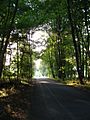
It's a special place where four long-distance footpaths meet: the Angles Way, Icknield Way, Iceni Way, and Peddars Way. The Peddars Way is even part of the Norfolk Coast Path, which is a National Trail.
The Icknield Way is a multi-user route, meaning it's great for walkers, horse riders, and off-road cyclists. It joins with the Peddars Way at the end of its 110-mile journey from Ivinghoe Beacon in Buckinghamshire. The Hereward Way also ends nearby in East Harling and is connected to the heath by a path.
How to Visit
There are several ways to get to Knettishall Heath. Most access points are off the road between Knettishall and Rushford villages. The main car park is on an unnamed road, sometimes called Heath Road, off Spalding's Chair Hill. The A1066 road also passes close by, running from Thetford to Garboldisham.
Gallery
-
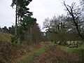
Peddars Way on the heath
-
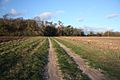
Icknield Way nearby
-
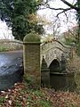
Bridge over River Little Ouse
-
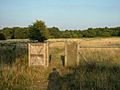
Footpath on the heath
-
Dew Pond on Knettishall Heath
-
Meeting point of Icknield Way (left) and Peddars Way (right)


