
Royston, Hertfordshire facts for kids
Quick facts for kids Royston |
|
|---|---|
 St John the Baptist, Royston |
|

Royston
|
|
| Population | 17,448 (2021 Census) |
| OS grid reference | TL357406 |
| Civil parish |
|
| District |
|
| Shire county | |
| Region | |
| Country | England |
| Sovereign state | United Kingdom |
| Post town | ROYSTON |
| Postcode district | SG8 |
| Dialling code | 01763 |
| Police | Hertfordshire |
| Fire | Hertfordshire |
| Ambulance | East of England |
| EU Parliament | East of England |
| UK Parliament |
|
Royston is a town and civil parish located in the District of North Hertfordshire. It is part of the county of Hertfordshire in England.
The town sits on the Greenwich Meridian, which is an imaginary line that marks zero degrees longitude. This line passes near the town's eastern edge. Royston is also at the northernmost point of Hertfordshire. It is about 43 miles (69 km) north of central London. The area around Royston is mostly rural, with lots of countryside.
Before the 1890s, the border between Hertfordshire and Cambridgeshire ran right through the middle of Royston. It followed Melbourn Street. As of 2021, Royston has a population of 17,448 people.
Contents
History of Royston

Royston grew up where two very old roads crossed. These roads were Ermine Street and the Icknield Way. Ermine Street was built after the Romans took over Britain. The Icknield Way is much older, thought to be a path used since prehistoric times. These roads were important for travel and trade.
Today, the A505 follows part of the Icknield Way, going around the north of the town. The A10 follows Ermine Street south of Royston. Northwards, the A1198, also known as the Old North Road, follows Ermine Street. Ancient burial mounds called barrows on Goffers Knoll and Therfield Heath show that people lived here long ago.
The Roysia's Cross
At some point, a cross was put up where the two main roads met. It was known by different names, like Royse's Cross or Roisia's Cross. This cross gave the settlement its first name, Crux Roesia. By the 1300s, the name had changed to Roisia's Town, Roiston, or Royston. Today, a large stone, believed to be the base of the cross, is located at the northern end of High Street.
Early Religious Buildings
Until 1540, Royston was split between five different church areas (parishes). These were Barkway, Reed, and Therfield in Hertfordshire, and Melbourn and Kneesworth in Cambridgeshire. In 1540, Royston became its own church parish.
An Augustinian priory (a type of monastery) was founded in Royston. It started as a small chapel for three canons (religious leaders) and later grew. Royston also had two hospitals or chapels, besides the monastery.
- The hospital of St John and St Thomas was built in 1224. It was for people with leprosy and was located on the south side of Baldock Street.
- The hospital of St Nicholas was founded around 1200 on the Cambridgeshire side of Royston. In 1213, King John allowed a fair to be held there. Both hospitals later came under the same control and were closed in 1547.
After the monastery closed, the land was taken by Robert Chester. He was a gentleman who worked for Henry VIII. He started a market in the town. Many inns were built in Royston to serve travellers going between London and York.
King James's Palace

In 1603, James VI and I visited Royston on his way to be crowned King of England. He stayed at the Chester residence. He loved the area for hunting and decided to build a royal hunting lodge there. He bought and knocked down two inns, the "Cock" and "Greyhound," to make space.
The king's new buildings were finished in 1607. They were made of brick and were quite large. The palace was not big enough for a full royal court. However, it was a perfect place for hunting. It was close enough to London to be convenient but far enough away for privacy. King James often returned to Royston to hunt. He even made a rule that no one could hunt within 16 miles (26 km) of Royston.
Queen Anne and Henry Frederick, Prince of Wales, visited Royston in 1611–1612. Later, a marriage contract for Princess Elizabeth was signed there. After her wedding, King James, Prince Charles, and Frederick stayed in Royston.
King Charles I, James's son, visited Royston less often. In 1647, during the English Civil Wars, Charles was brought through Royston as a prisoner. After King Charles was executed, the royal buildings fell apart. The Crown sold its last interests in Royston in 1866.
Royston's Local Bank
Royston had its own local bank, called the Royston Bank, from about 1806 to 1896. It was started by Edward King Fordham and others. The Fordham family, who were important locally, ran the business. The bank later joined with other banks to become Barclays.
Corn Exchange and Church Fire
A covered building for trading corn, called the Corn Exchange, was built on Market Hill in 1829.
The Church of England parish church of St John the Baptist was badly damaged by a fire in December 2018. The fire destroyed part of the roof and bell tower. The church was reopened in November 2022, almost four years later.
How Royston is Governed
Royston has three levels of local government: town, district, and county.
Royston Town Council
The Royston Town Council was created in 1974. It took over from the Royston Urban District Council. The council has fifteen councillors, led by a town mayor. Councillors are elected from three areas: Heath, Meridian, and Palace.
The Town Council is in charge of things like:
- Allotments (small plots of land for gardening)
- Royston Cave
- Royston Museum
- Local festivals
- Public halls
- The town's war memorial
In 2007, Royston Town Council received an award for being a "Quality Town Council." This means it meets high standards set by national groups.
The Town Council uses the same coat of arms that was given to the urban district council in 1952. The symbols on the shield tell a bit about the town's history. The staff represents Royston Priory. The roses show its connections to the Tudor period. King James I is shown by the checkered pattern of the Stewarts. The deer (hart) represents Hertfordshire. The crest shows a hooded crow, which is known as a "Royston crow" in the area. It stands on the "Royce Stone" in the town centre.
Since 2009, Royston has also had a Business Improvement District (BID) called Royston First. This group works to improve the town for businesses.
District and County Councils
Since 1974, Royston has been part of the North Hertfordshire district. The district council is based in Letchworth. It also covers towns like Baldock and Hitchin. There are 49 district councillors. Royston's three wards each elect two councillors.
Hertfordshire County Council has 78 councillors. Two of these are elected for Royston and the surrounding area.
Geography of Royston
Royston is located on the northern slopes of the Hertfordshire Chalk Downs. The Greenwich Meridian passes through the town. You can find a signpost marking it on the north side of Newmarket Road.
Transport in Royston
Royston is at the meeting point of the A10 and A505 roads. These are important roads for getting around Hertfordshire and beyond. The town is also close to major motorways like the A1(M) and M11. These roads provide fast links to London and the north.
For air travel, Luton Airport and Stansted Airport are both nearby. These are big airports in the South of England.
Royston railway station offers direct train services to London Kings Cross and Cambridge railway station. It is on the Cambridge Line and has regular services.
In 2012, a new rail crossing for people walking and cycling was opened. This £3.25 million subway connects the northern part of town to the leisure centre and the main schools area.
Schools in Royston
Royston's schools are set up in a specific way:
- First Schools (Years Reception–4): Icknield Walk First School; Roman Way Academy; Studlands Rise First School; Tannery Drift First School.
- Middle and Upper Schools (Years 5–11): King James Academy Royston. This school was formed by combining Greneway Middle School, Roysia Middle School, and the Meridian School.
- There is also St Mary's Roman Catholic Primary School (Years N-6).
Media in Royston
Local news and TV shows for Royston come from BBC East and ITV Anglia. TV signals are received from the Sandy Heath TV transmitter.
The town is covered by BBC Three Counties Radio and BBC Radio Cambridgeshire. Other radio stations include Heart Hertfordshire, Star Radio, and Royston Radio, which is a local community station.
The Royston Crow is the town's local weekly newspaper. It is published every Thursday.
Landmarks and Attractions

Therfield Heath (also known as Royston Heath) is a public open space and nature reserve. It sits on a hill southwest of the town and offers great views. The Icknield Way Path passes through the area. This path is 110 miles (177 km) long.
In 1742, a mysterious cave carved out of chalk was found in the middle of Royston. Royston Cave is located underneath the town's central crossroads. The carvings inside the cave have led to many ideas about why it was made and what it was used for.
Town Partnerships
The Royston and District Twinning Association helps coordinate twinning relationships with other towns around the world. Royston is twinned with:
- Großalmerode, Hessen, Germany
- La Loupe, Eure-et-Loir, France
- Villanueva de la Cañada, Comunidad de Madrid, Spain
Sports and Leisure
Royston Golf Club is on Therfield Heath and was started in 1892. It has 18 holes, practice areas, a pro shop, and a clubhouse.
Royston has a Non-League football club called Royston Town F.C.. They play at Garden Walk. The team currently plays in the Southern League Premier Division Central league.
Royston Sports Club is also on the heath. It is home to the town's tennis, squash, hockey, and rugby clubs. It also hosts youth football. Royston Rugby Club's main team plays in the Herts/Middlesex 1st division. Their Girls' U15 team won the Herts Shield in both 2011 and 2012.
Notable People from Royston
Many interesting people have come from Royston, including:
- Trumpeter Alison Balsom.
- Blues singer and guitarist Danny Bryant.
- Singing coach Carrie Grant.
- Television screenwriter Geoff McQueen.
- Theologian Thomas Cartwright, who helped start Presbyterianism in England, is said to have been born in Royston.
- Fellow theologian Edward Stallybrass.
- Theatre manager William Morton, born in 1838, grew up in Royston. Morton Street is named after his father.
- Theatre director Robin Belfield and meteorologist Simon King grew up in Royston.
- Poet Thomas Peyton and anatomical model maker Joseph Towne were both born in the town.
- Astronomer and mathematician Henry Andrews moved to Royston in 1766 and is buried in St John's Church graveyard.
- Thomas Kefford (active 1710–1750), a famous English clockmaker, ran his business in Royston.
Images for kids
-
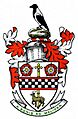
Royston Urban District Council coat of arms
-
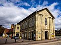
Royston Town Hall, Melbourn Street, Royston


See also
 In Spanish: Royston (Hertfordshire) para niños
