
A10 road (England) facts for kids
Quick facts for kids
|
|
|---|---|
 |
|
| Route information | |
| Length | 90.41 mi (145.50 km) |
| Major junctions | |
| South end | London Bridge51°30′28″N 0°05′14″W / 51.5079°N 0.0872°W |
| North end | King's Lynn52°45′14″N 0°23′53″E / 52.754°N 0.398°E |
| Location | |
| Primary destinations: |
Southwark Enfield Hertford Buntingford Royston Cambridge Ely |
| Road network | |
|
|

The A10 is a really important road in eastern England. It's like a main highway that connects the busy city of London all the way up to King's Lynn, a town near the coast. This road is super old! For much of its journey, it follows the path of an ancient Roman road called Ermine Street. The A10 stretches for about 90 miles (140 km) (which is about 145 kilometers) in total.
Contents
What is the A10 Road?
The A10 is known as an 'A road' in the United Kingdom. These roads are major routes that connect towns and cities. They are important for travel and moving goods across the country. The A10 helps people get from London to many places further north.
History of the A10
The A10 has a very long and interesting history. It isn't just a modern road. A big part of its route follows an ancient Roman road called Ermine Street. The Romans built this road thousands of years ago. They used it to connect their important settlements.
Roman Road Connections
Ermine Street was a key route for the Romans. It linked London (which they called Londinium) to Lincoln (Lindum Colonia) and York (Eboracum). The A10 uses the southern part of this historic route. This shows how important this path has been for centuries.
Where Does the A10 Go?
The A10 starts in the heart of London. It then travels north through several counties. It passes through Hertfordshire and Cambridgeshire. Finally, it reaches Norfolk, ending in King's Lynn.
Connecting Major Towns and Cities
As the A10 leaves London, it goes through areas like Enfield. Further north, it passes through historic towns such as Hertford and Royston. It then reaches the famous university city of Cambridge. After Cambridge, it continues towards Ely, known for its beautiful cathedral. The journey ends in the port town of King's Lynn.
Important Road Connections
The A10 crosses paths with many other important roads. It connects with the M25 motorway, which is a big ring road around London. It also meets the M11 motorway, which goes towards East Anglia. These connections make the A10 a vital link in the UK's road network. It helps drivers reach many different parts of England.
Images for kids
-

A10 in the City of London
-
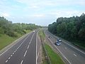
A10 outside Hertford facing south towards London
-
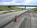
A10 Wadesmill bypass undergoing remedial work before opening


