Patawalonga River facts for kids
Quick facts for kids Patawalonga |
|
|---|---|

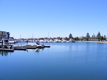
The Patawalonga River near its mouth
|
|
|
Location of the river mouth in South Australia
|
|
| Other name(s) | Patawalonga Creek |
| Country | Australia |
| State | South Australia |
| Region | Metropolitan Adelaide |
| District | Cowandilla Plains |
| Towns | Glenelg |
| Physical characteristics | |
| Main source | near Adelaide Airport |
| River mouth | Gulf St Vincent Glenelg North 0 m (0 ft) 34°58′12″S 138°30′49″E / 34.9700°S 138.5136°E |
| Length | 7 km (4.3 mi) |
| Basin features | |
| Basin size | 210 km2 (81 sq mi) |
The Patawalonga River is a river in the western suburbs of Adelaide, South Australia. It's also known as Patawalonga Creek or "the Pat" by locals. The river flows through an area that used to be flat, swampy land called the Cowandilla Plains.
In the mid-1900s, this area was drained by special engineering projects. This allowed for the building of Adelaide Airport and new homes. The river's water comes from the western Adelaide Hills. It then flows into Gulf St Vincent near Glenelg.
In 2001, the Barcoo Outlet was built. This helps move dirty stormwater away from the river's mouth and out to sea. This created a small lake or lagoon at the river's end.
Contents
What is the Patawalonga River?
The Patawalonga River is about 7 kilometres (4.3 mi) long. Before European settlement, it was a tidal estuary, meaning it was affected by ocean tides. The river collects water from a large area of metropolitan Adelaide, covering 210 square kilometres (81 sq mi). This area is south of the River Torrens and includes the western side of the Adelaide Hills. The river's mouth is at Glenelg.
How Does the River Flow?
The Patawalonga collects water from several creeks. These include Keswick, Brownhill, and the Sturt River. The Sturt River used to be a natural creek. Now, much of it is a large concrete storm-drain.
The river drains flat, swampy lands once known as the Cowandilla Plains. This area includes suburbs like Cowandilla and Mile End. Many small natural waterways and swamps in this area have been replaced by drains.
The Adelaide Airport was built between the late 1940s and 1954. Part of its construction included the Cowandilla-Mile End Drain. This drain runs along the airport's northern boundary. It's also called Airport Drain where it flows along the western edge of the airport. This drain connects to the Patawalonga in several places near West Beach.
Warriparinga Wetlands
The river's catchment also includes the Warriparinga Wetlands. These artificial wetlands opened in 1998. They are near Marion. Their job is to filter stormwater before it flows through the Sturt River into the Patawalonga.
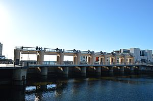
At the river's mouth, its flow is controlled by barriers called barrages. These are located at Glenelg North. The river then flows past the Holdfast Shores marina.
Why Was the River Dammed?
The idea to dam the Patawalonga came from Thomas King, a politician. In 1876, he suggested building a dam. This would make the river navigable for boats like yachts. It would also help reduce bad smells from the river's estuary.
The dam was built around 1885. Thomas King's work is remembered by a street and a bridge named after him. The original King Street Bridge was built in 1951. It was replaced by a new bridge in 2011, which was renamed the "Michael Herbert Bridge."
Even with the dam, the river's outlet still needs regular dredging. This means removing sand and seaweed so boats can pass. A disagreement about this dredging even led to the end of a high-speed ferry service. This service ran between Glenelg, Kangaroo Island, and Edithburgh from 1994 to 2007.
Understanding Water Quality Issues
The Patawalonga River has often had a bad smell since European settlement. This smell comes from seaweed growing in the shallow parts of the river. More recently, it's also caused by stormwater pollution.
When the outlet is dredged, seaweed can float back to shore. It then rots on the beach, causing a strong stench. Also, if too much fresh water flows into the Patawalonga, it can harm saltwater fish in the lake. This can also lead to unpleasant smells. For example, in January 2005, many fish died, and residents reported an "awful" smell.
What is the Barcoo Outlet?
By the 1970s, a lot of rubbish and dirty stormwater collected in the Patawalonga. This caused bad smells and made the water look dirty near Glenelg North. The pollution made the river unsafe for activities like swimming, water skiing, and dragon boat racing. In 1987, local authorities closed the Patawalonga for these activities due to health concerns.
In 1995, then-Premier Dean Brown asked for a review. The Environment Minister, David Wotton, even promised to swim in the river within a year. This was a symbol of their plan to clean up "the Pat."
Six years later, in December 2001, the Barcoo Outlet was finished. This project cost about A$30m. Its main goal was to divert dirty stormwater away from the Patawalonga Lake and out to sea. The Outlet is an 885-metre (2,904 ft) pipeline that carries stormwater away from the river's end. After it opened, then-Premier John Olsen took a swim in the Patawalonga. The government also lifted the ban on recreational use.
The Outlet project faced some problems at first. It sometimes failed to handle stormwater, leading to pollution on Adelaide's beaches. People north of the Outlet, especially at West Beach, complained that pollution was just moving to their beaches. The Outlet also failed during heavy rain in 2002 and 2003. This caused stormwater to enter the lake and even led to minor flooding in nearby homes.
Today, the lower part of the Patawalonga at Glenelg North works like a lake. Seawater is sometimes circulated in through the river mouth. It then flows out through the Barcoo Outlet to the north. The Outlet is named after the ship HMAS Barcoo. This ship ran aground at Glenelg North during a big storm in 1948.
The Flood of 2003
On June 27, 2003, heavy rainfall and a problem with the weir caused the Patawalonga to flood. The river broke its banks at Glenelg North, and homes were flooded. This became a big political issue. Premier Mike Rann announced a fund to help victims whose homes were damaged.
Reports suggested that 160 homes were affected. The flooding happened because the weir gates were kept closed during a stormwater flood. This was done to protect yachts in the Patawalonga Lake. About 145 residents made claims, and over A$1.4m was paid to them by the weir operator.
What Does "Patawalonga" Mean?
The name "Patawalonga" comes from the language of the Kaurna people, the Indigenous Australians of this area. It means "the place of the branches of the swamp gum."
Let's break it down:
- Patta means a swamp gum tree (Eucalyptus ovata).
- Wilya means a branch.
- Ngga is a suffix that shows it's a location.
So, patta-wilya-ngga means "swamp gum foliage place."
Other ideas for the meaning include "swamp of snakes" or "boggy and bushy stretch, with fish." The name was first written down by William Williams in 1839.
The river was originally called the "River Thames" by Europeans. It was also sometimes called the "Glenelg Creek." However, the Indigenous name "Patawalonga" remained popular. Governor Gawler encouraged settlers to learn Indigenous place names. He helped bring back several Kaurna names in Adelaide.
How Was the River Discovered by Europeans?
The State Library of South Australia says that Colonel Light discovered the Patawalonga River on October 4, 1836. He was sailing in a ship called Rapid and saw the river's mouth while looking for a good spot for the city of Adelaide.
The river's mouth became the first important river port for the new colony of South Australia. At that time, the Port River at Port Adelaide was shallow and hard for large ships to use.
One historian wrote about the river's early use:
- The first boat built in the Patawalonga was the 22-ton cutter O.G. in 1839. It got stuck until high tide because there was only 4 feet of water over the sandbar at the entrance.
- Large ships (over 300 tons) that couldn't enter Port Adelaide would drop off passengers and cargo at Glenelg. Goods that could float were put into the water and carried by the tide into the creek to the Customs House.
- The Customs House was built in 1839. Pilots still collected fees from the 35 fishing vessels on the Pat and for mail from steamers until the 1880s. At that time, it was called Port Glenelg.
The HMS Buffalo Replica
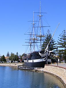
A famous part of the Patawalonga River is the replica of HMS Buffalo. The original Buffalo carried the first 400 settlers to South Australia in 1836. It also carried Captain Hindmarsh, who became the first Governor of South Australia. The replica of the Buffalo is now a floating restaurant on the Patawalonga.
 | Tommie Smith |
 | Simone Manuel |
 | Shani Davis |
 | Simone Biles |
 | Alice Coachman |


