Warriparinga facts for kids
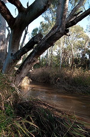
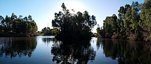
Warriparinga (also spelled Warriparingga) means "Windy Place" in the local Kaurna language. It's a special nature reserve covering about 3.5 hectares (8.6 acres) in Bedford Park, a southern suburb of Adelaide, South Australia. This area is also known as Fairford, Laffer's Triangle, or the Sturt Triangle. It's surrounded by Marion Road, Sturt Road, and South Road. The Sturt River flows through Warriparinga as it leaves Sturt Gorge and heads west across the Adelaide Plains.
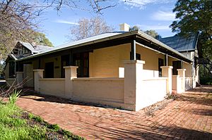
Warriparinga is important for many reasons. It has a rich history, deep cultural meaning, and a unique natural environment. For the Kaurna people, it was a traditional meeting place for ceremonies. It's also linked to the Tjilbruke Dreaming story and marks the start of the Tjilbruke Trail. The Living Kaurna Cultural Centre, a museum that shares Kaurna traditions, is located here. The area is also historically important because early European settlers arrived in the 1840s, soon after South Australia was founded. You can still see a historic farmhouse, mostly unchanged since the 1920s. There are also grape vines and fruit trees planted by those first settlers.
In 1998, Warriparinga was transformed into a native wetland. This wetland, filled with local plants and fish, helps clean water from the Sturt River before it flows into the Patawalonga River.
Contents
Exploring Warriparinga's Location
Warriparinga is a triangular piece of land in the southern Adelaide suburb of Bedford Park. It's bordered by Sturt Road to the north, Marion Road to the west, and South Road to the southeast. The Sturt River flows into Warriparinga from Sturt Gorge. From here, the river begins its journey across the Adelaide Plains, eventually joining the Patawalonga River.
Some of the Sturt River's water is sent into the Warriparinga Wetlands. After leaving Warriparinga, the river flows through a concrete drain until it reaches the Patawalonga in Glenelg North.
Warriparinga Before European Settlement
Before Europeans arrived, Warriparinga was very important to the local Kaurna people. It is the starting point for the Tjilbruke Dreaming story. This story explains how many of the freshwater springs south of Adelaide were formed. Warriparinga was also a camping ground for Indigenous people. The area had many animals like kangaroos, emus, and wallabies. There were also plenty of native food sources.
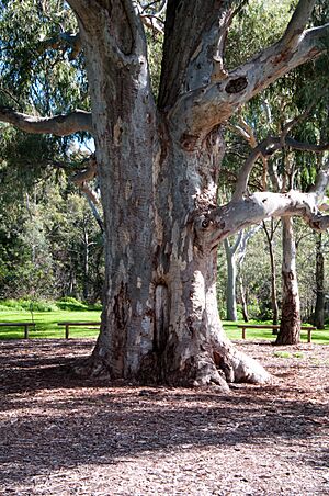
Evidence of traditional land use can still be seen today. There is a scarred tree, which may have been used to make a shield or a dish. Archaeologists have also found Aboriginal tools scattered in the area.
The Tjilbruke Dreaming Story
The Tjilbruke Dreaming is a significant story for the Kaurna people. In the story, Tjilbruke, his half-brothers Jurawi and Tetjawi, and his nephew Kulultuwi went hunting. Tjilbruke was tracking an emu when he became separated from the others. When he returned, he found that Kulultuwi had killed the emu Tjilbruke was hunting. This was against the law, as the emu now belonged to Tjilbruke. Kulultuwi apologized, and Tjilbruke accepted it, continuing his journey.
After Tjilbruke left, Kulultuwi's half-brothers killed him because he had broken the law. They carried his body to Warriparinga to prepare it for burial. Tjilbruke came looking for Kulultuwi. When he realized his nephew had been murdered, Tjilbruke killed Jurawi and Tetjawi at the site. Tjilbruke then carried Kulultuwi's body south to Patparno (Rapid Bay) for burial. He rested at different places along the way. Where he cried, his tears created freshwater springs. After Kulultuwi was buried, Tjilbruke's body turned into iron pyrite because of his deep sadness. His spirit then changed into a glossy ibis. This ibis symbol is often seen at Warriparinga today.
Warriparinga After European Settlement
After the city of Adelaide was established, the land was given to George Fife Angas in 1839. It was named "Fairford" after a local river crossing. It included land and a small cottage. In 1843, George Angas leased the site to Henry William Trimmer. Trimmer worked the land for many years. He eventually bought it from the South Australian Company in 1862 for £1,118.
Under Trimmer's care, Fairford grew to include over 13 acres (5.3 hectares) of vineyards. These vineyards had different types of grapes, like Gouais, Verdelho, Black Portugal, and Grenache. He also planted various fruit trees. Henry Trimmer became a respected grape grower. He even became Treasurer for the South Australian Vinegrowers' Association. The house was expanded, and a coach house was added in the 1860s. Some believe these improvements were designed by a famous architect, Edmund Wright.
When Trimmer died in 1867, the property went to his wife, Eliza Catherine Trimmer, and Edward Amand Wright. It was then sold to Henry Laffer in 1876. Henry Laffer continued farming the land. However, his son, Albert, decided to focus more on fruit trees than vineyards and grazing. The house was also changed during this time, especially in the 1890s and again in 1923. It then took on the look of a 1920s bungalow, which it still has today. The Laffer family lived on the property for 112 years, which is why it became known as "Laffer's Triangle."
Changes and Development Over Time
Over the years, many projects were considered for the Warriparinga property. Parts of the land were sold to different businesses and government groups. Warriparinga was even thought of as a site for big developments like the Marion Shopping Centre and Flinders Medical Centre. The medical centre moved because of concerns about a fault line under the property. The shopping centre was built further west.
Some projects that did happen included a holiday park, a restaurant (now closed), call centres, and the Sturt police station.
Three recent developments caused some debate. In 1991, the South Road bridge over the Sturt River was rebuilt. A local resident noticed the damage to the environment. This led to the creation of the "Friends of Laffer's Triangle" group. Environmental concerns also came up during the planning of the Southern Expressway. People worried the work would harm an important archaeological site at Warriparinga. Similar concerns arose in 2000 when the Ansett Australia Call Centre was proposed. Both environmental and cultural issues led to protests. However, like the other projects, the call centre was eventually built.
How Warriparinga Got Its Name
In 1992, Paul and Naomi Dixon began asking the Marion Council to protect the site. They wanted to create a "Warriparinga Interpretive Centre." The name Warriparinga means "windy river place." It comes from several Kaurna names and spellings recorded for the site, such as Warri Parri, Warriparri, Warreparinga, and Walpari.
Because of this, the "Friends of Laffer's Triangle" changed their name to "Friends of Warriparinga" in the early 1990s. As plans for the site developed, the name Warriparinga started to be used for the whole project and, over time, for the entire area. Eventually, the name was officially accepted for the Warriparinga Reserve and the Warriparinga Wetlands. Today, the name Warriparinga has almost completely replaced the older names.
The Warriparinga Wetlands Project
The Warriparinga Wetlands was a joint effort by the Marion Council, the Patawalonga Catchment Water Management Board, and the Land Management Corporation. The Land Management Corporation provided the necessary land. With a $1.7 million grant from the State Government, the wetlands were built. Their main purpose was to filter water from the Sturt River before it reached the Patawalonga River.
B C Tonkin and Associates designed the wetlands. Many groups were involved in the project. Since no archaeological study had been done before, one was organized. Also, because the site is so important to the Kaurna people, representatives from the Kaurna Aboriginal Community and Heritage Association were part of the planning group.
The final design includes four ponds. Water is directed into them from the Sturt River using a carefully placed fallen log. Native plants have been planted around the area. These include native food sources and plants used by Indigenous people for their fibers. The ponds were stocked with fish native to the area. These include southern black bream, bigheaded gudgeon, bridled goby, and common galaxias.
Work on the wetlands began in June 1998 and finished by December of that year. The wetlands were officially opened by John Olsen, who was the Premier of South Australia at the time, on December 16, 1998.
Awards for the Wetlands
In 1999, just one year after they were built, the Warriparinga Wetlands project won a State CASE Earth Award. These awards recognize excellent environmental engineering projects. In 2000, the wetlands received another honor: a commendation in the South Australian Engineering Excellence Awards. The judges praised how the developers handled the sensitive mix of cultural, residential, and business concerns, along with the engineering work.
The Living Kaurna Cultural Centre
The Living Kaurna Cultural Centre was first suggested in 1992 by Paul and Naomi Dixon. It was originally called the Warriparinga Interpretive Centre. Its goal was to teach visitors about the local Kaurna culture. After several years of talks, the project received $1.45 million in federal funding in 1998.
Even with funding, there were some challenges during its development. It was hard to get everyone involved to agree. The council even thought about giving up the federal grant at one point. There were also ongoing discussions about where to build the centre. The first idea was to build it across the Sturt River from Fairford House. However, costs and changes to the wetlands design prevented this. Another site at Warriparinga was considered, but the construction of the Ansett Call Centre took priority.
The final location, next to Fairford House, also raised some concerns. Some people worried it would look out of place next to the historic building. Despite this, the plan gained support from the council and Heritage SA, and construction went ahead.
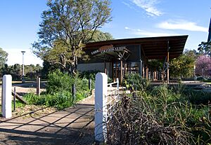
The Living Kaurna Cultural Centre was finished by early September 2002. It was officially opened later that month by Kaurna representatives, the Marion Council Mayor, and local politician Andrew Southcott. The building was designed by Phillips/Pilkington Architects Pty Ltd and Habitable Places. It has a corrugated iron roof shaped like an ibis's wings. This design directly connects to the Tjilbruke Dreaming story. The centre includes an art gallery, a café, a shop, and a large stage. It is used for education, cultural events, and selling Aboriginal products.
Art and Cultural Events at Warriparinga
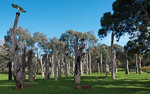
At Warriparinga, you can find an art installation called Tjilbruke narna arra, Tjilbruke Gateway. This artwork represents the Tjilbruke Dreaming story. It was created by artists Sherry Rankine, Margaret Worth, and Gavin Malone for the City of Marion. The artwork features several tree trunks grouped together. These trunks are decorated with symbols from the Dreaming story.
For example, circles around some trunks represent the freshwater springs created by Tjilbruke's tears. Flows of colored sands show the gully winds and the "flow of the river and of life." An ibis figure placed above iron pyrite symbolizes Tjilbruke's final transformation. One of the goals of this artwork is to provide a place where Kaurna people can share the Dreaming stories.
Warriparinga has also hosted many important cultural events recently. These include the "friendship fires" started in 1999 by Georgina Williams. These fires were lit at each full moon. Up to 150 people gathered for these events. They helped Kaurna people stay connected to the land. A similar fire was lit in May 2004 and burned for several days as part of National Reconciliation Week. This 2004 fire was the main focus of many local celebrations and events during that time.
Other Reconciliation Week events at Warriparinga include the 2009 launch of the first new bark canoe since European settlement. Paul Dixon built this canoe using traditional techniques. He carved it from a tree found in nearby Mitchell Park.
 | Delilah Pierce |
 | Gordon Parks |
 | Augusta Savage |
 | Charles Ethan Porter |


