
Rapid Bay, South Australia facts for kids
Quick facts for kids Rapid BaySouth Australia |
|||||||||||||||
|---|---|---|---|---|---|---|---|---|---|---|---|---|---|---|---|

Patpangga / Rapid Bay shoreline
|
|||||||||||||||

Rapid Bay
Location in South Australia
|
|||||||||||||||
| Population | 16 (2016 census) | ||||||||||||||
| Postcode(s) | 5204 | ||||||||||||||
| Time zone | ACST (UTC+9:30) | ||||||||||||||
| • Summer (DST) | ACDT (UTC+10:30) | ||||||||||||||
| Location | 100 km (62 mi) S of Adelaide | ||||||||||||||
| LGA(s) | District Council of Yankalilla | ||||||||||||||
| Region | Fleurieu and Kangaroo Island | ||||||||||||||
| County | Hindmarsh | ||||||||||||||
| State electorate(s) | Mawson | ||||||||||||||
| Federal Division(s) | Mayo | ||||||||||||||
|
|||||||||||||||
|
|||||||||||||||
| Footnotes | Adjoining localities | ||||||||||||||

Rapid Bay is a small seaside town and bay located on the west coast of the Fleurieu Peninsula in South Australia. It's part of the District Council of Yankalilla. The town is about 100 kilometers (62 miles) south of Adelaide, the state capital. Rapid Bay is famous for its two jetties, which are great for recreational fishing, scuba diving, and snorkelling. Many people visit to see the amazing leafy seadragons living in the wild here. The postcode for Rapid Bay is 5204.
Contents
Rapid Bay's Past: A Look at History
Rapid Bay is important in the traditional stories of the Kaurna and Ramindjeri peoples. One story tells that it's the burial place of the nephew of the Kaurna creator ancestor named Tjilbruke. The Kaurna name for Rapid Bay might be Patparno, Patpangga (meaning "south place"), or Yarta-kulangga, which was a popular camping spot. Today, the bay is officially known by two names: Rapid Bay and Patpangga.
Before South Australia became a colony, whalers from Kangaroo Island visited Rapid Bay. However, it wasn't called Rapid Bay until 1836. On September 8, 1836, Colonel William Light, who was the first Surveyor General for South Australia, landed here. He named the place after his ship, the 162-ton brig called the Rapid. To remember this important landing, Colonel Light's initials, "W.L.", were carved into a large rock. You can see a copy of this rock in the town, while the real one is kept safe in the South Australian Museum in Adelaide.
For a short time, Colonel Light thought about making Rapid Bay the capital city of the new colony. But then the Adelaide Plains were discovered, which was a better spot. So, Rapid Bay became a quiet place. After his first visit, Light planted a garden and left the bay to the sealers from Kangaroo Island and the local Aboriginal people.
Quarrying for Limestone
Between 1938 and 1942, a company called BHP built the town of Rapid Bay. They also built a long jetty for loading ore and a power line from Willunga. This was all part of setting up a limestone quarry. During the jetty's construction, a worker named John Gamlin disappeared and was thought to have fallen into the water and drowned.
The quarry started working in 1942. The limestone was sent by sea to BHP's steel factories in Whyalla, South Australia, and also to Newcastle and Port Kembla in New South Wales. The limestone was used as a special material called "flux" in making steel.
By 1948, the quarry was producing about 30,000 tonnes of limestone each month. The process was fully machine-operated, from digging the rock to crushing it, and then moving it by conveyor belt onto ships. About 41 people worked at the quarry at that time.
In 1981, BHP sold its quarry assets, including the crushing plant, jetty, and loading wharf, to another company called Adelaide Brighton Cement. On January 1, 1982, the jetty was given to the Government of South Australia for free.
From 1942 to 2013, it's estimated that 17 million tonnes of limestone were taken from the quarry. Most of this was used for industrial purposes. A small amount of material is still quarried from the site today for building roads. The story of Rapid Bay during the BHP years was written in a book called Rapid Bay... Before we forget. History and memoirs of a mining town by Des Lord in 2018.
Fun Things to Do: Rapid Bay Attractions
Rapid Bay is known for its tall cliffs, cool caves, sandy beach, and its two jetties. It also has an artificial reef which helps marine life grow. The bay is home to a group of amazing leafy seadragons, and sometimes you can even spot weedy seadragons too!
Many people think Rapid Bay is one of the best places for scuba diving in South Australia and even Australia. It has been called one of the world's top nine dives! The jetty piles are covered in marine life, attracting big groups of fish like Old Wives and Zebra Fish. More than 70 different kinds of fish have been seen in Rapid Bay. You can also find many cool sea creatures like the Australian giant cuttlefish and the blue-ringed octopus living around the jetty.
Rapid Bay is also a popular place for fishing. You can fish from the shore, from a boat, from a kayak, or from the public jetty. The old industrial jetty is now closed because it's falling apart.
Rapid Bay's Jetties
The very first jetty at Rapid Bay was built in the late 1860s. It was made of wood and was meant to help export wool and wheat. This first jetty was about 50 yards away from where the later BHP jetty was built.
The Old BHP Jetty
The BHP Jetty was originally about 488 meters (1600 feet) long. It had a 'T' shaped end that was about 198 meters (650 feet) long for loading ships. The end of the jetty reached water that was about 9 meters (30 feet) deep at low tide. This jetty was first built by BHP and later used by Adelaide Brighton Cement. It stopped being used for commercial shipping in 1991.
In 2004, the jetty was damaged by a storm. For safety reasons, parts of it were slowly closed off to the public. Above the water, the jetty is slowly decaying. But below the water, it's a home for many different kinds of marine animals. Since it closed, the parts of the jetty above water have also become a valuable resting place for seabirds. Sadly, the jetty collapsed in January 2022.
The New Public Jetty
A new jetty was built in 2009 to replace the public access lost when the old BHP jetty closed. This new jetty is about 240 meters (787 feet) long and is located about 50 meters (164 feet) east of the old BHP jetty.
Marine life has started to grow on the new jetty, adding to the already rich underwater world around the old jetty. At the end of the new jetty, there's a staircase that makes it easy and safe for divers and snorkelers to get into the water. The jetty has a concrete deck, is lit up at night, and is a favorite spot for recreational fishing.
Gallery
-
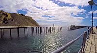
Rapid Bay old jetty, viewed from new jetty
-
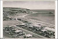
View of the Town, the Quarry and the Jetty looking west towards Rapid Head (image created in 1950)
-
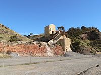
The limestone quarry at Rapid Bay as seen from the public car park for the jetty.


