Port River facts for kids
Quick facts for kids Port River |
|
|---|---|

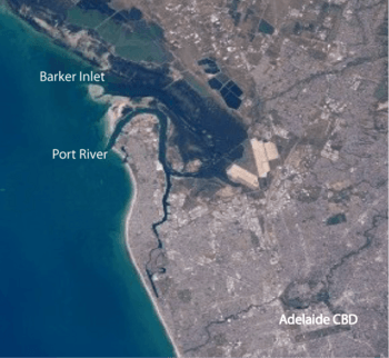
The Port River in relation to Adelaide city centre, the redirected River Torrens, and the adjacent Barker Inlet
|
|
|
Location of the river mouth in South Australia
|
|
| Other name(s) | Port Adelaide |
| Country | Australia |
| State | South Australia |
| Region | Western Adelaide |
| Municipality | City of Port Adelaide Enfield |
| Physical characteristics | |
| Main source | Semaphore Park 34°51′S 138°29′E / 34.85°S 138.49°E |
| River mouth | Gulf St Vincent Outer Harbor 0 m (0 ft) 34°47′S 138°28′E / 34.78°S 138.47°E |
| Basin features | |
| Tributaries |
|
| Bridges |
|
The Port River (also called the Port Adelaide River) is a special kind of waterway called a tidal estuary. It's located north of the Adelaide city centre in South Australia. People have used it as a shipping route since 1836. This was when Colonel Light chose the spot for a port during the early European settlement.
Before Europeans arrived, the Kaurna people called this area Yerta Bulti (or Yertabulti). They used the river and its surroundings to find food and materials for their daily lives.
Contents
What is the Port River?
The Port River is the western part of the biggest tidal estuary on the eastern side of Gulf St Vincent. An estuary is where a river meets the sea, and the water is a mix of fresh and salty. The whole estuary area is sometimes called the Port River estuary. It includes places like Barker Inlet, Torrens Island, and Garden Island. It also touches many suburbs like Port Adelaide and Outer Harbor, South Australia.
The river banks are used for shipping, factories, and homes. The river is home to a rich ecosystem with mangroves, seagrass, waterbirds, and lots of marine life. In the past, pollution from factories caused problems. But now, pollution has been reduced, and the environment is getting better thanks to special programs.
The estuary has several protected areas. These include the Adelaide Dolphin Sanctuary and the Gulf St Vincent Important Bird Area. There are also many ships' graveyards and other interesting historical spots. Four bridges cross the river, including three for cars and one for trains.
Naming the Port River
Before European settlement, the Kaurna people called the Port River area Yerta Bulti. This means "land of sleep or death." The specific spot where Port Adelaide is now was known as Yartapuulti. Today, the river's official name is the Port Adelaide River. However, many people still call it the Port River.
History of the Port River
Life Before European Settlement
Before 1836, the Port River was a shallow, narrow tidal creek. It wound through mangrove swamps. The Kaurna people lived here. Their land stretched from Cape Jervis in the south to Crystal Brook in the north. It included the Adelaide Plains and the Adelaide city centre.
The Kaurna people used the river's natural resources. They caught fish, lobsters, and birds. They also collected bird's eggs, black river mussels, and blue swimmer crabs. They used reeds and rushes to weave baskets and nets. These nets helped them catch fish and animals like kangaroos and emus. They called dolphins yambo.
A large sand dune system, called the Gillman Dunal system, was in the southern part of the area. The Kaurna people camped there for many years, even after Europeans arrived.
Today, Lartelare Park is north of the Jervois Bridge. It was built in 2009 to remember a Kaurna campsite. This camp was there for thousands of years until 1858. Many shell middens (piles of shells from old meals) and tools were found when the park was built.
European Arrival and Development
Captain John Jones officially "discovered" the river in 1834. Captain Collet Barker had seen it earlier in 1831. In 1836, Colonel William Light chose a landing spot for Adelaide. This first spot was south of the current port and was known as "Port Misery" because of its poor conditions. It later became known as the Old Port.
In 1837, a harbour was officially created. The first migrants landed on the mangrove-lined river bank. Later, a canal was dug through the mangroves to a higher spot. The first wharf was built where Old Port Road and Frederick Road meet today.
The McLaren Wharf was built in 1839. The main port opened in its current location (now Port Adelaide) in October 1840.
Because the river was shallow, a new harbour was built at Outer Harbor. It started in 1902 and finished in 1908. This allowed bigger steamships to dock there. Smaller boats still used the old port.
The first bridge over the river was a wooden footbridge built in 1859. It helped people get to the Lefevre Peninsula.
River Course and Features
A long time ago, the River Torrens used to flow into the Port River. But sediment built up, blocking the channels and creating a large marshland called "the Reedbeds." In 1937, a channel called Breakout Creek was built to send the Torrens directly to the sea.
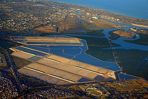
The Port River is the western part of the largest tidal estuary on the eastern side of Gulf St Vincent. It goes inland through the historic Inner Harbour of Port Adelaide. It also connects to the man-made salt-water West Lakes. The lower part of the Port River flows between the Lefevre Peninsula and Section Banks and Torrens Island. This area forms the sea entrance to Adelaide's port.
Section Banks is an artificial island made of seashell grit, clay, and sand. It's about 1600 meters long. It was partly formed naturally and partly by people. It's a nesting area for seabirds and is also called Bird Island.
The Port River estuary connects to the Barker Inlet to the east. This happens through the North Arm and Angas Inlet.
Bridges Over the River
In 1878, the first Jervois Bridge opened. It replaced the 1859 footbridge. This bridge had a special part that could swing open to let ships pass. Later, the Birkenhead Bridge opened in the 1940s. It was the first bascule bridge (a bridge that lifts up) in Australia. In 1966, a new Jervois Bridge was built a bit further upstream.
In the 2000s, the Port River Expressway was built. The bridge over the Port River, called the Tom 'Diver' Derrick Bridge, opened on August 3, 2008. This expressway connects major roads to the port.
Today, the river is crossed by the Expressway bridge, the Birkenhead Bridge, the Jervois Bridge, and a railway bridge for the Outer Harbor railway line.
Shipping and Industry
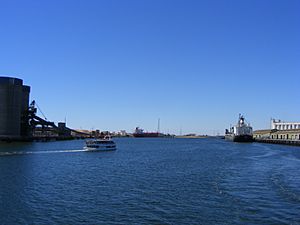
The banks of the Port River are mostly used for factories and shipping. They have some of Adelaide's wharves and facilities for handling large amounts of cargo and shipping containers. Big ship transport vessels use the main channel of the river. Port Adelaide is a tidal port, meaning the water level changes with the tides. It has many shipping berths (places where ships dock) along the estuary.
ASC (which used to be the Australian Submarine Corporation) has its building and repair facility for submarines at Osborne.
There's also a historic Quarantine Station on Torrens Island. Several power stations, like the Torrens Island Power Station and the Pelican Point Power Station, use water from the Port River for cooling.
Fun and Attractions
You can still find some mangrove forests along the estuary. One of the best attractions is the Port River dolphins. They are the only wild dolphins in the world that live inside a city! The Adelaide Dolphin Sanctuary protects all of the Port River estuary and a part of the sea north of St Kilda.
A fishing fleet operates from the North Arm, which also has a speed boat club. You can find places for recreational boating in the Angas Inlet and on the Lefevre Peninsula.
The Port Adelaide Rowing Club moved to Largs North in 1957. The river used to be a popular place for rowing races.
In December 2016, the annual "Long Swim" in the Inner Harbour started again. This was after many years when it couldn't happen because of water pollution.
Kaurna Cultural Heritage Trail
The Port Adelaide Kaurna Cultural Heritage Trail is near the Ship's Graveyard. It goes along both sides of the river between two bridges. It has six important Kaurna sites. Signs explain many things about Kaurna culture and their life on the estuary.
Ships' Graveyards
There are places where old ships were left to decay, called ships' graveyards. You can find them at Angas Inlet and Broad Creek in the Barker Inlet.
Further up the river, in a part known as Port Creek, is the Jervois Basin Ships' Graveyard. Several old ships lie here between the Outer Harbor railway line bridge and the Jervois Bridge. These include the Alert, Trafalgar, Fides, and the Fitzjames. The Fitzjames was even used as a floating boys' reformatory for a while!
Mutton Cove Ships' Graveyard is inside the Mutton Cove Conservation Reserve. You can see the wreck of the old steamship Excelsior here. The old iron barge Jupiter is also here, covered by mangroves.
The North Arm has another big ships' graveyard, now called Garden Island Ships' Graveyard. It has 25 identified wrecks! These old ships, abandoned between 1909 and 1945, are now homes for birds and a cool place for canoeing. The ships include the Santiago and Dorothy H. Sterling.
River Environment
The Port River estuary is a very important natural area. Its health depends on the water, the areas that are sometimes covered by water (intertidal zone), and the land along the shore. This area is a breeding and feeding ground for many kinds of fish and prawns, like western king prawns and King George Whiting. It's also home to both local and migratory birds, including a rookery (a place where birds nest). And, of course, it's a sanctuary for dolphins.
The area has the largest mangrove forest, shallow seagrasses, and mudflats in Gulf St Vincent. People are trying to bring back the large reefs of shellfish that used to be here. These include native mud oysters, cockles, and razorfish, which almost disappeared after European settlement.
Before European settlement, winter rains made the Reedbeds wetlands very wet. This water flowed north into the Port River. The Port River estuary and Barker Inlet were surrounded by mudflats, mangroves, and saltmarshes. Many of these still exist, but the water flow has changed a lot. The tides have a big effect on the plants and animals in the estuary.
Since settlement and factories were built, stormwater has caused pollution in the estuary. Factories released nutrients that caused algal blooms and other harmful substances. Power stations also changed the water temperature.
Water quality has improved a lot since 2005. This is because wastewater is now treated better. Also, a soda ash plant that caused a lot of ammonia pollution closed in 2014.
Regular water testing showed very low levels of bacteria in December 2016. This allowed the annual "Long Swim" in the Inner Harbour to start again after many years.
Mangrove forests (made of only one type of mangrove, Avicennia marina) are still found in places like Ethelton and New Port. They are also along Torrens Island and the North Arm. Spring tides can be over 2.5 meters high. At low tide, mudflats are exposed, which are breeding grounds for blue swimmer crabs and other sea creatures.
Protected Areas for Wildlife
Several protected areas are set up by law to help keep the area's amazing variety of life safe. These include:
- Adelaide Dolphin Sanctuary: This is a 118 square kilometer sanctuary for dolphins. It covers all of the Barker Inlet and the Port River. Bottlenose dolphins are often seen here, following boats. They are a well-known tourist attraction.
- Adelaide International Bird Sanctuary
- Barker Inlet – St Kilda Aquatic Reserve
- Gulf St Vincent Important Bird Area (the mudflats at the river's mouth)
- Mutton Cove Conservation Reserve
- St Kilda – Chapman Creek Aquatic Reserve
- Torrens Island Conservation Park
Scientists are concerned about the dolphins because the industrial nature of the Port River has led to some dolphins having high levels of heavy metals in their bodies.
Future Risks to the Environment
Climate change is causing rising sea levels. This threatens to cause erosion and the loss of mudflats, salt-marsh, and mangroves. The water level has been rising by about 2 millimeters each year. After a big storm in 2016, the seawall at the Mutton Cove Conservation Reserve broke. Now, the area is regularly flooded by the river. This will cause some plants to die off and mangroves to grow more.
 | Valerie Thomas |
 | Frederick McKinley Jones |
 | George Edward Alcorn Jr. |
 | Thomas Mensah |


