Osborne, South Australia facts for kids
Quick facts for kids OsborneAdelaide, South Australia |
|||||||||||||||
|---|---|---|---|---|---|---|---|---|---|---|---|---|---|---|---|

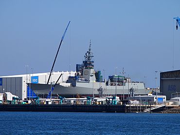
HMAS Hobart being built at Osborne, 10 April 2015.
|
|||||||||||||||
| Postcode(s) | 5017 | ||||||||||||||
| Time zone | ACST (UTC+9:30) | ||||||||||||||
| • Summer (DST) | ACST (UTC+10:30) | ||||||||||||||
| Location | 21 km (13 mi) from Adelaide city centre | ||||||||||||||
| LGA(s) | City of Port Adelaide Enfield | ||||||||||||||
| Region | Western Adelaide | ||||||||||||||
| County | Adelaide | ||||||||||||||
| State electorate(s) | Port Adelaide | ||||||||||||||
| Federal Division(s) | Hindmarsh | ||||||||||||||
|
|||||||||||||||
|
|||||||||||||||
| Footnotes | Adjoining suburbs | ||||||||||||||
Osborne is a suburb located in South Australia. It is found on the Lefevre Peninsula, which is west of Adelaide. Osborne is about 21 kilometres (13 miles) north-west of the Adelaide city centre.
Contents
About Osborne
Osborne is surrounded by other suburbs and water. To the south is Taperoo. To the west is Gulf St Vincent, a large bay. To the north-west, you'll find North Haven and Outer Harbor. The suburb of Torrens Island is to the east.
History of Osborne
Osborne began as a private land division. It was named after Captain R.W. Osborne, who lived from about 1834 to 1920. The name was officially adopted in 1951.
Over the years, Osborne's boundaries have changed a few times. Some parts were renamed North Haven. In 2006, the boundaries were adjusted to include the Osborne Maritime Precinct. This area is important for sea-related activities. In 2009, its eastern boundary was extended to the middle of the Port River.
A post office called Osborneville opened around 1922. It was later renamed Taperoo in 1964 and then North Haven in 1989. Osborne was also known as Brooklyn for a while after its name changed from Osborneville.
Industries in Osborne
Osborne is home to several important industrial businesses. These companies provide many jobs.
- ASC Pty Ltd: This company builds ships for the Royal Australian Navy. They have built Collins class submarines and Hobart-class destroyers.
- Osborne Power Station: This is a power station that uses gas to create electricity.
- Flinders Ports: This company manages two port facilities along the Port River. These ports help move goods in and out of the area by ship.
Community Life
Osborne has a place called LeFevre Reserve. This reserve also has a community centre where people can gather for activities.
There are no schools directly in Osborne. However, nearby suburbs have schools. North Haven has North Haven School for younger students. Taperoo has Ocean View College, which used to be Taperoo High School, for older students.
Getting Around Osborne
Public transport helps people travel in and out of Osborne.
- Bus Services: Adelaide Metro provides bus services. Route 333 runs between Osborne and Port Adelaide. Route 150 starts in Osborne and goes to the Adelaide city centre.
- Train Services: The Outer Harbor railway line has two stations that serve the area: Midlunga railway station and Osborne railway station. The Osborne station is actually located in the nearby suburb of North Haven. The Dry Creek–Port Adelaide railway line also passes through Osborne. This line carries freight trains to the Outer Harbor container and grain export terminals, crossing the Mary MacKillop Bridge.
How Osborne is Governed
Osborne is part of different government areas. These groups help manage the suburb and its services.
- Federal Government: Osborne is in the federal division of Hindmarsh. This means people in Osborne vote for a representative in the national parliament.
- State Government: For state matters, Osborne is in the electoral district of Port Adelaide. This means people vote for a representative in the state parliament.
- Local Government: At a local level, Osborne is part of the City of Port Adelaide Enfield. This local council handles things like parks, roads, and community services.
 | Victor J. Glover |
 | Yvonne Cagle |
 | Jeanette Epps |
 | Bernard A. Harris Jr. |


