Lefevre Peninsula facts for kids
Quick facts for kids Lefevre PeninsulaSouth Australia |
|
|---|---|

The Lefevre Peninsula is on the west side of the Port River
|
|
| LGA(s) | City of Port Adelaide Enfield |
| Region | Western Adelaide |
| County | Adelaide |
| State electorate(s) |
|
| Federal Division(s) | Hindmarsh |
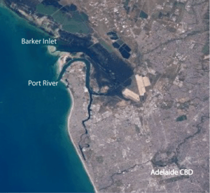
The Lefevre Peninsula is a long piece of land in South Australia. It sticks out into the sea, like a finger pointing north. It's about 15 kilometres (9.3 mi) northwest of the main city of Adelaide.
This land is a narrow sand spit, which means it's a thin strip of sand formed by ocean currents. It covers about 30 square kilometres (12 sq mi). The original owners of this land, the Kaurna people, called it Mudlangga. This name means "nose-place" in their language.
Contents
Where is Lefevre Peninsula?
The Lefevre Peninsula is home to about 30,000 people. It's located on the eastern side of Gulf St Vincent. This gulf is a large bay on the coast of South Australia.
The peninsula has water on three sides. To the west, it faces Gulf St Vincent with its beaches. To the north and east, it's bordered by the Port River. This river separates it from the rest of the mainland. The southern end of the peninsula is near Recreation Road in Semaphore Park.
Towns and Suburbs on the Peninsula
Many towns and suburbs are located on the Lefevre Peninsula. These include:
- Semaphore
- Semaphore Park
- Semaphore South
- Ethelton
- Glanville
- New Port
- Exeter
- Birkenhead
- Peterhead
- Largs Bay
- Largs North
- Taperoo
- Osborne
- North Haven
- Outer Harbor
What is Lefevre Peninsula Like?
The western side of the peninsula has beautiful, long stretches of white sand beaches. These beaches face the open waters of Gulf St Vincent. The eastern side is different. It's next to the Barker Inlet and Port River.
Much of the peninsula is developed. There are many homes built behind the western beaches. Along the Port River on the eastern side, you'll find large industries.
Industry and Transport
The peninsula has a strong connection to the sea. This is because it's close to Port Adelaide, the Port River, and Outer Harbor. For example, Collins class submarines were built in the suburb of Osborne. Also, Cement is made at Birkenhead.
In 1999, the Pelican Point Power Station was built here. It's at the very top of the peninsula, next to the Port River. The peninsula also has several sailing clubs and golf courses. The popular Semaphore Road foreshore is a great place to visit.
The Outer Harbor railway line runs through the peninsula. It carries passengers from Ethelton to Outer Harbor. There's also a separate freight railway. This line crosses the Mary MacKillop Bridge and runs along the eastern side. It serves the large grain and container docks at Pelican Point.
How Lefevre Peninsula Got its Name
Before Europeans arrived, the Kaurna people lived here. They called the peninsula Mudlangga. This means "nose-place" in their language. Some think it might have looked like a kangaroo's nose.
The current name was given by John Hindmarsh. He was the first Governor of South Australia. On June 3, 1837, he named it after Sir John George Shaw-Lefevre. Sir John was one of the people who helped set up the colony of South Australia.
History of the Peninsula
A long time ago, before it was built up, much of the coastline was covered with mangrove trees. The land was also full of native plants. These included wattle and sheoak trees. The eastern side of the peninsula was part of the natural river system of the Port River.
European settlers started to arrive and build homes in the early 1840s.
How Lefevre Peninsula is Governed
The Lefevre Peninsula is part of the City of Port Adelaide Enfield. This is its local government area. For state elections, the peninsula is in the Lee and Port Adelaide areas. For federal elections, it's in the Hindmarsh area.
 | James Van Der Zee |
 | Alma Thomas |
 | Ellis Wilson |
 | Margaret Taylor-Burroughs |


