Barker Inlet facts for kids
Quick facts for kids Barker Inlet |
|
|---|---|

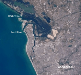
The inlet in relation to Adelaide's Central business district
|
|
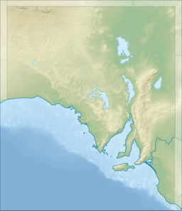
| Location | South Australia |
| Coordinates | 34°44′42″S 138°30′00″E / 34.745°S 138.50°E |
| Type | Inlet |
| Etymology | Collet Barker |
| Part of | Gulf St Vincent |
| River sources | Dry Creek, Little Para River |
| Basin countries | Australia |
| Settlements | Adelaide |
The Barker Inlet is a special tidal area of water in Adelaide, South Australia. It's like a narrow arm of the sea, connected to the Gulf St Vincent. It was named after Captain Collet Barker, who first saw it in 1831.
This inlet is home to some amazing things! It has one of the most southerly mangrove forests in the world. It's also a safe place for dolphins and has important seagrass meadows. Many fish and shellfish use it as a breeding ground.
The Barker Inlet separates Torrens Island and Garden Island from the main land. It has many small tidal creeks, deeper channels made by people, and wide, flat areas of mudflats. The thick mangrove forests are surrounded by samphire saltmarsh flats and low sand dunes.
You can find two boardwalks here, one at Garden Island and another at St Kilda. There are also old ships graveyards in areas called Broad Creek, Angas Inlet, and the North Arm. The Eastern Passage runs between Garden Island and the mainland. It gets narrower to form Angas Channel further north.
Over the years, the inlet has faced some challenges. Things like stormwater runoff, old sewage, and rubbish dumping have affected its plants and animals. However, many positive changes have happened. A large landfill dump on Garden Island was closed in 2000, and cleanup work began. Some stormwater is now cleaned through wetlands before it enters the inlet. The area has also been made a reserve to protect dolphins, fish, crabs, and aquatic plants.
Contents
What is the Physical Structure of Barker Inlet?
The Barker Inlet is a shallow area of water that changes with the tide. It formed over a long time as sand moved along the coast.
There's a narrow main channel in the inlet that boats can use. When the tide is high, the water can rise over 2½ metres. But at low tide, much of the inlet becomes exposed mudflats. Most of the smaller creeks through the mangroves are only deep enough for very small boats at high tide. There's also a special channel from a boat ramp at St Kilda, near the northern end of the inlet.
On the eastern side, many creeks are tidal. Swan Alley creek is where water from the Dry Creek and the Little Para River flows out. The North Arm Creek is the outlet for the Barker Inlet Wetlands. These wetlands were built in 1994 to help clean stormwater. They hold a lot of stormwater before it flows into the creek.
What Kind of Plants and Animals Live Here?
The Barker Inlet is full of life!
Flora (Plants)
The main type of tree here is the grey mangrove, called Avicennia marina. These mangroves cover most of the area. The surrounding salt flats have also changed over time. A plant called Tecticornia flabelliformis is now considered threatened in this area. In the deeper parts of the inlet, you'll find strap or tape weed (Posidonia spp.). In the shallower areas, you'll see eelgrass (Zostera muelleri) and garweed (Heterozostera tasmanica). These plants are often visible on the mudflats when the tide is low.
Fauna (Animals)
Many different animals call Barker Inlet home. Over 70 types of fish have been found here. There are also more than 110 kinds of crustaceans (like crabs) and almost 50 kinds of molluscs (like shellfish). Some common animals include western king prawns, King George and yellowfin whiting fish, and blue swimmer crabs.
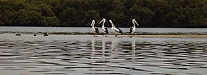
Many bird species visit or live in the inlet. You might see cormorants, terns, ducks, swans, pelicans, egrets, and herons. Silver gulls and white-bellied sea eagles are also common. If you include birds that migrate (travel long distances), over 250 different bird species have been seen in the inlet and its nearby wetlands and lagoons!
What Were the Former Uses of Barker Inlet?
From 1906 to 1972, a part of the inlet called Broad Creek was used to unload explosives. These explosives were then moved by a small tramway to a storage area.
Today, you can find abandoned ships in Broad Creek, Angas Inlet, and the North Arm. These are the remains of over 30 old iron and wooden ships that were left there before 1945. Now, they are cool places for birds to rest and a fun spot for canoeing.
What Protected Areas are in Barker Inlet?
The Barker Inlet is part of several protected areas. These areas help keep the environment safe and healthy.
Reserves by the South Australian Government
The Barker Inlet is connected to:
- The Adelaide Dolphin Sanctuary, which protects dolphins.
- The Barker Inlet – St Kilda Aquatic Reserve, which protects the water and its creatures.
- The southern part of the St Kilda – Chapman Creek Aquatic Reserve.
- The Torrens Island Conservation Park, which helps protect the land.
Other Important Areas
The Barker Inlet is also recognized as an important wetland system in Australia. It's known as 'Barker Inlet & St Kilda'. It's also at the southern end of an area called the Gulf St Vincent Important Bird Area. This means it's a very important place for many different kinds of birds.
 | Bessie Coleman |
 | Spann Watson |
 | Jill E. Brown |
 | Sherman W. White |


