
Gilberton, South Australia facts for kids
Quick facts for kids GilbertonAdelaide, South Australia |
|||||||||||||||
|---|---|---|---|---|---|---|---|---|---|---|---|---|---|---|---|
| Established | 1840s | ||||||||||||||
| Postcode(s) | 5081 | ||||||||||||||
| Location | 2 km (1 mi) from Adelaide GPO | ||||||||||||||
| LGA(s) | Town of Walkerville | ||||||||||||||
| State electorate(s) | Adelaide | ||||||||||||||
| Federal Division(s) | Adelaide | ||||||||||||||
|
|||||||||||||||
Gilberton (once called Gilbert Town) is a suburb located just north of Adelaide city centre in South Australia. It sits on the northern side of the River Torrens. The suburb is surrounded by the river, Park Terrace, Stephen Terrace, and Northcote Terrace.
Gilberton is mostly a place where people live. You can find many large and beautiful Victorian houses here. About 2 kilometers (1.2 miles) of the Torrens Linear Park forms its southern edge along the river. The big, old homes in the northern part of Gilberton give it a special historic feel. This character is protected by local planning rules.
Contents
A Look Back: Gilberton's History
The land that is now Gilberton was first bought in 1839. It was part of the original survey of Adelaide. Later, in 1846, a man named Joseph Gilbert bought this land. He was famous for his Pewsey Vale winery.
Joseph Gilbert paid £600 for the 134-acre (54-hectare) section. He named it "Gilbert Town." In 1852, he divided the land into 43 smaller pieces to sell or rent. In the early days, Gilberton had a brickworks, farms, gardens, and even an abattoir (a place where animals are processed for meat).
The southern part of the town was planned by 1847. The full plan was finished by 1871. Many houses were built in the area by the 1890s.
Land and Views
The land in Gilberton is mostly flat from the river up to Walkerville Terrace. Then, it slopes upwards towards its northern boundary. Because of these higher spots, the northern part of Gilberton offered great views. This made it attractive to wealthier people who wanted to build large homes. Many of these grand Victorian houses, with their big gardens, are still there today.
Near a large bend in the River Torrens, where St Peters River Park is now, different businesses operated. These included digging for gravel, washing sand, and using the area as a landfill (a dump). The sand washing business was replaced by a dump in 1961. This led to complaints from the nearby suburb of St Peters about smoke from burning rubbish. Eventually, the land was bought by St Peters. The river bend was straightened, and the dump site was cleaned up.
Gilberton's River Activities
The Gilberton Bathing Reserve
A part of the River Torrens was once a popular swimming spot. It was held back by weirs (small dams). This was home to the Gilberton Swimming Club, which started in 1915. Many local children learned to swim here.
A very important event held at this spot was the Australian Swimming Championships. This competition took place from February 17 to 24, 1923. Thousands of people came to watch, lining the western bank of the river.
People still used the area for casual swimming in the 1950s. However, it was later closed because of the presence of E coli bacteria in the water. Many things from the Swimming Club days are still there. This includes the beautiful Memorial Arch. It was built in 1936 to honor Percy Frank Jervis, who greatly helped the Club.
The "Swing" Bridge
Near the old swimming area is a pedestrian suspension bridge. It connects Severn Street in Gilberton to Swing Bridge Lane in St Peters. Charles Francis Muller built this bridge in 1920 for Frank Woolley, a large landowner.
In 2017, the bridge was rebuilt to meet modern safety standards. This was a joint project between the Town of Walkerville and the City of Norwood Payneham & St Peters. It reopened in February 2018. Locals use it regularly, and visitors find it interesting. The original anchor structures, which are historically and architecturally important, have been kept. The Torrens Linear Park also runs very close by.
Images for kids
-
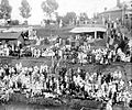
Spectators on the river bank during the Australian championships in February 1923.

