Christies Beach, South Australia facts for kids
Quick facts for kids Christies BeachAdelaide, South Australia |
|||||||||||||||
|---|---|---|---|---|---|---|---|---|---|---|---|---|---|---|---|

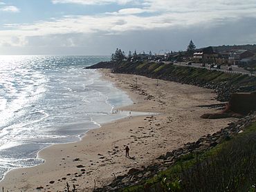
View of the Christies Beach coastline from Witton Bluff
|
|||||||||||||||
| Established | 1925 | ||||||||||||||
| Postcode(s) | 5165 | ||||||||||||||
| Location | 26 km (16 mi) from Adelaide city centre | ||||||||||||||
| LGA(s) | City of Onkaparinga | ||||||||||||||
| Region | Southern Adelaide | ||||||||||||||
| County | Adelaide | ||||||||||||||
| State electorate(s) | Reynell | ||||||||||||||
| Federal Division(s) | Kingston | ||||||||||||||
|
|||||||||||||||
|
|||||||||||||||
| Footnotes | Coordinates Location Climate Adjoining suburbs |
||||||||||||||
Christies Beach is a cool seaside suburb located in the southern part of Adelaide, Australia. It's part of the City of Onkaparinga. This area is really pretty and a favorite spot for photographers. That's because Witton Bluff offers an amazing view over the whole town and the sparkling ocean.
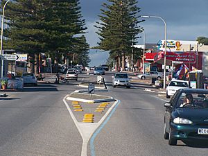
Christies Beach has a special shopping street called Beach Road. It runs all the way to the beach! This area is known as an important coastal hub in Adelaide. You can also find one of the few main roads, called the Esplanade, that goes right to the beach on Gulf St Vincent.
The postcode for Christies Beach is 5165. It's next to Christie Downs and Noarlunga Centre to the east. To the south is Port Noarlunga, and to the north is O'Sullivan Beach.
Just offshore from Christies Beach, you can see Horseshoe Reef when the tide is low. In 2021, a new artificial reef was built about 500 meters out from Christies Creek. This helps sea life grow!
Contents
How Christies Beach Grew
Early Days: The Kaurna People
The story of Christies Beach goes back almost 40,000 years. Long before Europeans arrived, the Kaurna people, who are Indigenous Australians, lived here. They called this coastal area Mullawirratingga. They would stay here during the summer. They built small shelters called wodli from branches and leaves. These homes were temporary, used only for the summer, then taken apart.
Whalers and Farmers
The first Europeans came to Christies Beach in the 1830s. They built a whaling station here. They hunted southern right whales because whale products were valuable. Witton Bluff was a great spot to watch for whales. But by the 1840s, the whales changed their migration path. The whalers then left the area.
In 1838, land from Glenelg to Witton Bluff became available. Many farmers settled near Anderson Creek, now called Christies Creek. In 1895, Lambert Christie and his wife Rosa started a farm. This farm covered the land where Christies Beach is today.
A Town is Born
The area stayed mostly farmland until 1923. That's when Rosa Christie divided some of her land into smaller blocks. She named this new area Christie Beach. With more homes being built, roads and train lines improved. This made it easier for tourists and holidaymakers to visit the coast. Many people built small cottages and holiday homes on Witton Bluff and right on the beach.
As more people came, the Christies Beach Progressive Association was formed. They wanted to make the beach better for everyone. They helped create new facilities like toilets and showers. New shops and services opened on the Esplanade and nearby roads. By the late 1950s, many people wanted to live here. This led to more businesses and factories opening nearby. The Christies Beach Post Office opened in 1945. It was renamed Christies Beach around 1961.
What's Happening Now and in the Future
Improving the Foreshore
The foreshore, which is the area along the beach, already has many great things. There are toilets, benches, and barbecue spots. You can find native plants, fences, and signs with information. There are also stairs to the beach and paved paths. Recently, power lines along the Esplanade were moved underground. This makes the views even better!
Exciting Plans Ahead
There are plans to make the Christies Beach foreshore even better. They want to create special parking areas. More native plants will be added, and there will be more open grassy spaces for everyone to enjoy. The footpaths will become multi-use paths for walkers and cyclists. These paths will connect to other coastal paths nearby. There are also plans for a coastal trail from Christies Beach to Port Noarlunga, called The Witton Bluff Base Trail.
Sports and Fun
Christies Beach has a central spot for sports called the John Bice Memorial Oval. This is where the Christies Beach Football Club and the Southern Districts Cricket Club play. It's also home to the Christies Beach Sports and Social Club.
If you love water sports, check out the Christies Beach Sailing Club. The Christies Beach Surf Lifesaving Club helps keep everyone safe in the water. There's also a small concrete ramp for launching boats.
Historical Spots to See
Morrow Road Bridge
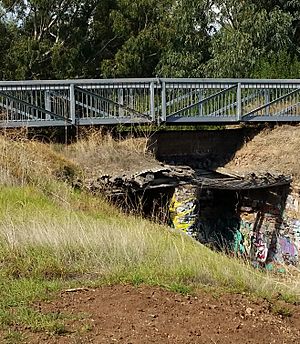
The Morrow Road bridge crosses Christies Creek. It's a Local Heritage place. This bridge used to be the main road connecting Christies Beach to O'Sullivan Beach. It's special because it's thought to be the only wooden road bridge left from the old Noarlunga Council area.
Parks and Green Spaces
Christies Beach has several lovely parks where you can relax and play.
Lohmann Park
You can find Lohmann Park on Galloway Road. It's home to a special statue called The Rainmakers. This statue shows bronze Aboriginal warriors. It was given to the people by Eugen Lohmann, a German building company director. The statue was officially revealed in 1965. The park also has a memorial for Alan Oakes, a former local councilor.
D. M. Coe Reserve
D. M. Coe Reserve is an open space with a small playground. It's located between Vincent Street and Dorothea Street. The reserve is named after Daphne Mary Coe, who was a councilor for the former City of Noarlunga.
Ron Gill Reserve
This reserve is on the corner of Brixton Street and Clovelly Avenue. It has three tennis courts, a basketball hoop, and public toilets. There's also a small playground and the Ron Gill Memorial Hall. The hall is used by the Rotary Club of Noarlunga. The reserve is named after Ron Gill, who was the first president of the Rotary Club of Noarlunga in 1966.
Tom McBeath Reserve
Tom McBeath Reserve is located near Vincent Street and King Street. It has open space and some trees. The Christies North Kindergarten is here, along with a hall that used to belong to the 1st Christies Beach Scout Group. It's named after Tom McBeath. He was a former president of the Rotary Club of Noarlunga and supported the Christies Beach Meals on Wheels.
Peters Park
Peters Park on Archer Street was officially named in 2019. It's named after the Peters Family. They have a long history in the neighborhood and have helped care for the park for over 55 years. Allan Peters worked to get the park landscaped in 1972. He and his family have spent years cleaning up the park and even decorated nearby power poles with murals!
 | Valerie Thomas |
 | Frederick McKinley Jones |
 | George Edward Alcorn Jr. |
 | Thomas Mensah |


