Onkaparinga River Recreation Park facts for kids
Quick facts for kids Onkaparinga River Recreation ParkSouth Australia |
|
|---|---|
|
IUCN Category III (Natural Monument)
|
|

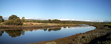
Onkaparinga Estuary
|
|
| Nearest town or city | Port Noarlunga South |
| Established | 7 November 1985 |
| Area | 2.67 km2 (1.0 sq mi) |
| Managing authorities | Department for Environment and Water |
| Website | Onkaparinga River Recreation Park |
| See also | Protected areas of South Australia |
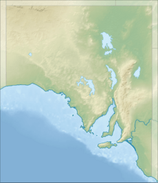
The Onkaparinga River Recreation Park is a special place in South Australia. It protects land around the mouth of the Onkaparinga River. This park was created in 1985 and is about 32 kilometres (20 miles) from Adelaide city centre. It's a great spot for fun outdoor activities like walking, canoeing, kayaking, fishing, and picnics.
Contents
What is the Onkaparinga River Recreation Park?
This park covers most of the river area between Main South Road near Old Noarlunga in the east and Port Noarlunga in the west. The park land is found within the suburbs of Noarlunga Downs, Port Noarlunga South, and Seaford Meadows.
A path for walking and cycling, called the Coast to Vines Rail Trail, goes through the park. It follows an old railway line. The Seaford railway line also crosses over the park on a long bridge. This bridge is about 1.2 kilometres (0.75 miles) long and was built between 2011 and 2014. The park is listed as an IUCN Category III protected area, which means it's important for protecting natural features.
Why was the Park Created?
Most of the land in the recreation park was bought by the South Australian government between 1973 and 1977. The government had three main reasons for buying this land along the Onkaparinga River:
- To create open spaces for people to enjoy outdoor activities.
- To protect the natural beauty of the area, including its plants and animals.
- To act as a natural barrier between city areas and rural areas.
In 1982, the land was given to the Department for Environment and Heritage. They officially opened the recreation park in 1985. Later, in 1993, the land east of Main South Road became the Onkaparinga River National Park. Both the recreation park and the national park are managed together as the 'Onkaparinga River Reserve'.
Who Lived Here Before?
Aboriginal History of the Land
Studies show that Aboriginal people have used the land around the river's mouth for a very long time. Evidence from archaeological digs suggests they lived here continuously for at least 7,500 years before Europeans arrived.
European Settlement and Farming
In February 1839, land in this area became available for European settlers. Much of the land that is now the park was bought around 1861 by John Jared, an immigrant from England. He started a farm called 'Clear Farm' and built a house in 1862. His son, John William, took over the farm in 1871 and renamed it 'Pringle Farm'. The Jared family owned the farm until the 1970s. Today, the old buildings of Pringle Farm are still protected within the park.
Fun Things to Do at the Park
The Onkaparinga River Recreation Park has many walking tracks. Two popular ones are the Wetlands Walk on the north side of the river and the Pringle Farm Walk on the south side. You can also go canoeing, kayaking, and fishing in the Onkaparinga River within the park.
If you bring your Dog to the park, remember to keep it on a leash at all times. The park also has car parks, toilets, and picnic areas for visitors.
There's even a small airfield in the park's southeast corner, called the Old Noarlunga Airfield. It's used by two clubs: one for flying vintage aircraft and another for flying model aircraft.
Protected Areas Nearby
The Onkaparinga River, from the park's eastern edge to Port Noarlunga, is part of two other protected areas. These are the Port Noarlunga Reef Aquatic Reserve and the Encounter Marine Park. In the aquatic reserve, you are only allowed to do line fishing and use hand nets for catching bait shrimp.
 | Delilah Pierce |
 | Gordon Parks |
 | Augusta Savage |
 | Charles Ethan Porter |


