Blair Athol, South Australia facts for kids
Quick facts for kids Blair AtholAdelaide, South Australia |
|||||||||||||||
|---|---|---|---|---|---|---|---|---|---|---|---|---|---|---|---|

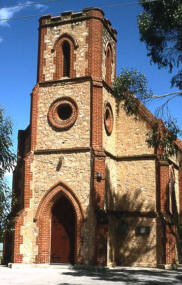
St Clements Anglican church on Main North Road, Blair Athol
|
|||||||||||||||
| Postcode(s) | 5084 | ||||||||||||||
| LGA(s) | City of Port Adelaide Enfield | ||||||||||||||
| State electorate(s) | Enfield | ||||||||||||||
| Federal Division(s) | Adelaide | ||||||||||||||
|
|||||||||||||||
Blair Athol is a suburb located in Adelaide, South Australia. It is about 6 km (4 mi) north of the main city center. Blair Athol shares its borders with other suburbs like Gepps Cross, Enfield, Prospect, and Kilburn.
The suburb has a rectangular shape. It stretches from Grand Junction Road in the north down to Angwin Avenue in the south. On its sides, you'll find Prospect Road to the west and Main North Road to the east. Florence Avenue is the longest and most important street in Blair Athol.
Contents
History of Blair Athol
Blair Athol started as a private land division. This means a large piece of land was divided into smaller plots to be sold. This happened in an area called section 357 in the Hundred of Yatala. The name "Blair Athol" was officially recognized in 1944. At that time, its borders were from Grand Junction Road to Irish Harp Road (which is now Regency Road).
In 2000, a part of Blair Athol was joined to the nearby suburb of Prospect. This part was south of Angwin Avenue.
Gepp's Cross Connection
An old area known as Gepp's Cross is partly located in the northeast corner of modern Blair Athol. Gepp's Cross was named after a busy intersection of Main North Road and Grand Junction Road. The historic Gepps Cross Hotel, also called Gepp's Cross Inn, is in this area. Today, the suburb of Gepps Cross is only the land north of that intersection.
Post Office Changes
The Blair Athol Post Office first opened on June 15, 1955. In 1966, its name was changed to Blair Athol West. At the same time, the older Enfield post office, which had been open since 1852, was renamed Blair Athol. This post office was later replaced by the Enfield Plaza office in 1997.
Parks and Green Spaces
Blair Athol has several lovely parks, which are called reserves. These include Blair Athol Recreational Reserve, Barton Street Reserve, Dingley Dell Reserve, Anson Street Reserve, and Dover Street Reserve.
Blair Athol Recreational Reserve
The Blair Athol Recreational Reserve is a very large park. It covers about 4.68 hectares (about 11.5 acres). This reserve is a great place for sports and fun.
- It has a field for Australian rules football.
- There's a cricket ground with special batting cages.
- You can find two courts for netball and basketball.
- There are also tennis courts, used by members of the Kilburn tennis club.
- The reserve has two playgrounds for younger kids.
- There's a gazebo, which is a small open building, perfect for picnics.
- It is home to the Kilburn Football & Cricket Club.
- A large parking lot makes it easy to visit.
Barton Street Reserve
Barton Street Reserve is another nice park in Blair Athol. It has a big grassy field, perfect for running around or playing games. There's also a playground with several benches where you can relax. This reserve is about 1.84 hectares (about 4.5 acres) in size.
Shopping in Blair Athol
Blair Athol has some unique shops. You can find Randall's Hardware, which is one of the few family-owned hardware stores left. Right next to it is another family-owned business called Pets Everywhere.
There used to be a Coles Supermarkets store on the corner of Florence Avenue and Prospect Road. This supermarket closed in July 2016. The site was then redeveloped and reopened in 2017 as an IGA supermarket. This IGA is special because it sells products from countries like Afghanistan, Iran, and Pakistan. The Kilburn Post Office is located just across the road from this supermarket.
Getting Around Blair Athol
Blair Athol has good public transport options, making it easy to travel around.
Bus Services
- The G10 bus line travels between Adelaide and Grand Junction Road. It goes along Prospect Road.
- Other bus routes like 221, 222, 224, 225, 226, 228, 229, G10A, and G10B also serve the area. These buses travel between Adelaide and different places in the Northern suburbs, using Main North Road.
Train Services
Residents of Blair Athol can also catch the train line to and from the city. The train station is located in Kilburn, which is just a few hundred meters from Prospect Road.
 | Kyle Baker |
 | Joseph Yoakum |
 | Laura Wheeler Waring |
 | Henry Ossawa Tanner |

