
Belair National Park facts for kids
Quick facts for kids Belair National ParkSouth Australia |
|
|---|---|
|
IUCN Category II (National Park)
|
|

View from the Waterfall Hike
|
|

Belair National Park
Location in South Australia
|
|
| Nearest town or city | Adelaide, South Australia |
| Established | 1891 |
| Area | 8.35 km2 (3.2 sq mi) |
| Visitation | 358,619 (in 2003) |
| Managing authorities | Department of Environment and Water |
| Website | Belair National Park |
| See also | Protected areas of South Australia |
Belair National Park is a special protected area in Belair, South Australia. It is about 13 kilometers south of the Adelaide city centre and covers an area of 835 hectares. This park was officially created in 1891. It was the very first national park in South Australia. It was also the second national park in all of Australia, after Sydney's Royal National Park. Globally, it was the tenth national park ever created. The park is located in the Adelaide Hills and is managed by the Department of Environment and Water. It is an important part of a group of protected areas along the Adelaide Hills.
Contents
What is Belair National Park called?
For many years, this special place was simply known as the 'National Park'. From 1972 to 1991, its name changed to the 'Belair Recreation Park'. Then, in 1991, the Belair Recreation Park was closed. The land it used to cover was officially made into a national park again. This time, it was given the name “Belair National Park”.
Who lived in Belair National Park first?
The land where Belair National Park now stands was originally home to the Kaurna Aboriginal people. They called the area Pradli. This name means “baldness” because the land looked bare, like the moon, when seen from the Adelaide Plains.
When did Europeans arrive in Belair?
The first Europeans to visit the area were sailors from a ship called the Coromandel in 1837. In 1839, a man named E. Nicholas Foott became the first European to settle there. He built a stone cottage and dug a well. He spent a lot of money, even though he didn't own the land.
In 1840, the governor of South Australia, George Gawler, decided to use the land as a government farm. This meant Foott had to leave, but he was paid for the improvements he made. Later, in 1848, a small house was built by the creek for the farm manager. It was also sometimes used by the governor.
What was the Governor's Summer House?
In 1858, a larger house was built. It even had a swimming pool! This was meant to be a "summer house" for the governor, Richard Graves MacDonnell. Other governors used it too, until a bigger house was built at Marble Hill, South Australia.
How did Belair become a National Park?
From 1874 to 1884, William Cook managed the Government Farm. During his time, two big bushfires happened in 1866/1867 and 1877. These fires destroyed many old trees.
In 1881, there were plans to sell off parts of the land. But people like Walter Gooch and groups like the Australian Natives Association disagreed. They wanted to protect the land. Because of their efforts, a law was passed in 1883 that stopped the land from being sold.
Later, in 1888, more people pushed for the Government Farm to become a public park. After some discussions, the National Park Act was approved in January 1892. This officially made Belair a national park.
In 1985, Belair National Park was recognized as a special heritage area. This means it is protected because of its history and importance.
What about plants in the park?

When Europeans first came to Belair, they brought many plants with them. Some of these plants were not native to Australia. They were planted on purpose or spread by accident. Now, many of these non-native plants have become weeds in the park. They can sometimes take over areas where native plants used to grow.
Even with these challenges, Belair National Park still has many rare native plants. You can find them in less visited parts of the park, especially along the walking trails. Look closely, and you might spot beautiful tiny flowers like Donkey Orchids and Spider Orchids in late winter.
Where is Belair National Park located?
Belair National Park is located about 13 kilometers southeast of Adelaide city centre in South Australia. It is in the suburb of Belair. This park is one of the few places in the Adelaide Hills that still has a lot of its original native plants and natural areas.
What can you do at Belair National Park?
Belair National Park is a great place for walking and exploring nature. There are many different walking trails for all skill levels.


- Wood Duck Dawdle: This is a short walk around Playford Lake. It's perfect for a quick stroll.
- Lorikeet Loop Walk: This walk is 3 kilometers long. It goes from the main car park to the Adventure Playground.
- Valley Loop Walk: Another 3-kilometer walk that takes you to Long Gully.
- Microcarpa Walk: This trail is 4 kilometers long. It starts near Playford Lake.
- Waterfall Hike: This is one of the park's most popular walks. It's a 6.5-kilometer loop that visits the park's waterfalls. It also goes into the higher, quieter areas away from the main recreation spots.
- Yurrebilla Trail: The first 5 kilometers of the long Yurrebilla Trail pass through Belair National Park. It starts at the Belair railway station and goes towards the Lower Waterfall. Then it leaves the park at the Sheoak Road boundary.
Belair National Park shows how much South Australia cares about protecting natural areas. It is a place for both keeping nature safe and for people to enjoy.
Images for kids
-
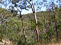
View from the Waterfall Hike
-
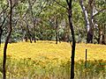
Invasive weed Hypericum perforatum in the Park
-
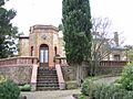
Old Government House, a historic building in Belair National Park.
-
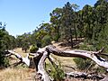
The end of the Waterfall Hike
-
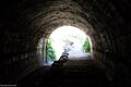
Tunnel at Belair National Park
-
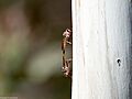
Mating odonata in Belair National Park
-
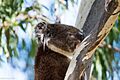
Koala in Belair National Park
See also
 In Spanish: Parque nacional Belair para niños
