Blanchetown facts for kids
Quick facts for kids BlanchetownSouth Australia |
|||||||||||||||
|---|---|---|---|---|---|---|---|---|---|---|---|---|---|---|---|

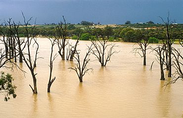
Dead gum trees in the Murray River near Blanchetown in 1989
|
|||||||||||||||
| Established | 1855 | ||||||||||||||
| Postcode(s) | 5357 | ||||||||||||||
| Location | 130 km (81 mi) northeast of Adelaide city centre | ||||||||||||||
| LGA(s) | Mid Murray Council | ||||||||||||||
| State electorate(s) | Chaffey | ||||||||||||||
| Federal Division(s) | Barker | ||||||||||||||
|
|||||||||||||||
| Footnotes | Adjoining localities | ||||||||||||||
Blanchetown is a small town in South Australia. It sits on the west bank of the Murray River, about 130 kilometers (81 miles) northeast of Adelaide. The Blanchetown Bridge is the first bridge you cross over the Murray River on the Sturt Highway when coming from Adelaide.
In the 1800s, Blanchetown was an important place for moving goods along the lower Murray River. Today, it's known for its mix of old buildings and holiday homes by the river. Many people see Blanchetown as the start of the Riverland area, a region famous for its fruit and beautiful river scenery.
Contents
Blanchetown's Early Days and History
Blanchetown is located on the traditional lands of the Ngarrindjeri people. The town was first mapped out in October 1855 and was originally called Blanche Town. It got its name from Lady Blanche MacDonnell, who was the wife of Sir Richard MacDonnell, the Governor of South Australia at the time.
The Governor himself chose this spot. It was meant to replace an older settlement called Murrundi (or Moorundee), which was about five kilometers (3 miles) downstream. Murrundi often flooded, so Blanchetown was a better choice. Murrundi had been the base for the "Protector of Aborigines" since 1841. This role was created to help and protect Aboriginal people.
River Crossings and Growth
A ferry started operating at Blanchetown in 1869, helping people cross the river. At first, it was privately owned, but the government took it over in 1879. By February 1876, Blanchetown was a small but growing town. It had about 50 people and a dozen houses. The buildings were made from strong stone found nearby. The main buildings included the post and telegraph office, a hotel, and a general store.
When land was first sold in Blanchetown, people thought a railway would be built there. Because of this, some plots of land sold for a very high price. However, by 1876, it became clear that the railway would not come through Blanchetown. This disappointed the residents. The railway line connecting Adelaide to Morgan, a town upstream from Blanchetown, opened in 1878. This new railway caused less riverboat traffic to Blanchetown, slowing its growth.
Historic Places in Blanchetown
Blanchetown has several places that are important because of their history. These are called heritage-listed sites:
- Adams Street: The Blanchetown Hotel
- 28-30 Egerton Street: The Blanchetown Post Office
- Off Swan Reach-Blanchetown Road: The Moorundie Settlement Ruins (remains of the older settlement)
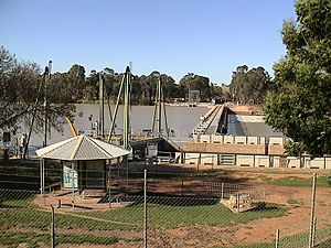
- The William R. Randell Lock and Weir (also known as Lock No. 1)
Local Industries and Facilities
Blanchetown is located north of Goyder's Line. This is an imaginary line in South Australia that shows where there's usually not enough rainfall for farming without extra water. So, the land around Blanchetown needs water from the Murray River to grow crops. Upstream from Blanchetown, the land above the river cliffs is mostly used for raising sheep. On the east bank, farmers use irrigation to grow citrus fruits like oranges and lemons.
The area around Blanchetown also includes the Brookfield Conservation Park. This park is west of the town and north of the Sturt Highway. It's a great example of the mallee bushland found near Goyder's Line. It's also home to southern hairy-nosed wombats, which are unique Australian animals. The Advent Lutheran Church Blanchetown is actually in Paisley, just a short distance north of the bridge's eastern end.
Understanding Lock 1 and the Weir
Lock 1 on the Murray River is located at Blanchetown. It was the very first of 13 locks and weirs built along the Murray River. It was finished in 1922. A lock is like a water elevator that helps boats move between different water levels. A weir is a low dam that helps control the water level.
The lock chamber is about 56 feet (17 meters) wide and 275 feet (84 meters) long. Originally, these structures were built to help boats travel easily for trade along the Murray. However, by the time all the weirs were built, river trade was already decreasing. Today, their main purpose is to help people enjoy boating and to keep water levels high enough for irrigation. The water level upstream of the weir is 3.6 meters (11.8 feet) above sea level. It is 274 kilometers (170 miles) from the Murray Mouth, where the river meets the ocean.
The Blanchetown Bridge
A bridge was built at Blanchetown in 1963. It was the first major bridge in South Australia made with a special type of concrete called prestressed concrete. In the 1990s, engineers found that this bridge wasn't strong enough for very heavy trucks, like B-double trucks.
Until a new bridge could be built, these large trucks had to take a much longer route. They were sent from near Monash through Morgan and Eudunda to rejoin the highway at Gawler. This meant they traveled further to avoid the older bridges at Kingston and Blanchetown. A new bridge was completed in November 1998. The original 1963 bridge is still there and can be used by people walking or riding bikes.
How Blanchetown is Governed
Blanchetown is part of the Mid Murray Council. This is the local government area that manages services for the town. For state government elections, Blanchetown is in the South Australian House of Assembly electoral district of Chaffey. For federal government elections, it is in the Australian House of Representatives Division of Barker. These divisions help decide who represents the area in parliament.
 | Charles R. Drew |
 | Benjamin Banneker |
 | Jane C. Wright |
 | Roger Arliner Young |


