
Mount Gambier facts for kids
Quick facts for kids Mount GambierSouth Australia |
|||||||||||||||
|---|---|---|---|---|---|---|---|---|---|---|---|---|---|---|---|

View north across Valley Lake and Marist Park to the eastern urban area of Mount Gambier from Centenary Tower
|
|||||||||||||||

Mount Gambier
Location in South Australia
|
|||||||||||||||
| Established | 1854 | ||||||||||||||
| Postcode(s) | 5290, 5291 | ||||||||||||||
| Area | 193.3 km2 (74.6 sq mi)(2011 urban) | ||||||||||||||
| Time zone | ACST (UTC+9:30) | ||||||||||||||
| • Summer (DST) | ACDT (UTC+10:30) | ||||||||||||||
| Location | |||||||||||||||
| LGA(s) |
|
||||||||||||||
| County | Grey | ||||||||||||||
| State electorate(s) | Mount Gambier | ||||||||||||||
| Federal Division(s) | Barker | ||||||||||||||
|
|||||||||||||||
|
|||||||||||||||
Mount Gambier is the second largest city in South Australia by population. In 2021, about 26,878 people lived there. The city sits on the slopes of Mount Gambier, a volcano in the state's southeast. It is about 450 kilometers (280 miles) southeast of Adelaide. It is also only 17 kilometers (11 miles) from the Victorian border.
The Bungandidj (or Buandik) people are the original owners of this land. Mount Gambier is a very important town in the Limestone Coast area. It is known for its amazing natural features. These include volcanoes, limestone caves, and sinkholes. The most famous is the Blue Lake /Waawor /Warwar.
History of Mount Gambier
Before British settlers arrived, the Bungandidj people lived here. They called the volcano's peak 'ereng balam' or 'egree belum'. This means 'home of the eagle hawk'. The mountain itself was called Berrin. A sinkhole in the town was known as "thu-ghee".
In 1800, Lieutenant James Grant saw the peak of the dormant Mount Gambier volcano. He named it after Lord James Gambier. This was the first place named by the British in what became South Australia. A tower called Centenary Tower was built in 1901. It marks where colonists first saw the peak.
In 1839, Stephen Henty explored the Mount Gambier area. He was the first European to climb the peak. He also saw the blue crater lake. The Henty brothers later started a sheep station here in 1842.
Early interactions between settlers and the local Aboriginal people were difficult. Over time, more settlers arrived and industries began to grow. The Post Office opened in 1846. The Mount Gambier Hotel was built in 1847. Dr Edward Wehl started a flour mill in 1849.

Hastings Cunningham started "Gambierton" in 1854. He divided a large piece of land into smaller blocks. From 1861 to 1878, the Post Office was called Gambierton. Then it changed back to Mount Gambier. Local government began in 1863. Dr Wehl became the first chairman of the District Council of Mount Gambier.
Mount Gambier officially became a city on December 9, 1954. Today, it is a key tourism spot in southeast South Australia.
As of October 2022, the city itself does not have two official names. However, many lakes and important cultural sites now have dual names. For example, Blue Lake is also called Warwar. The city might also get a dual name, likely Berrin. This is the name used by the local Indigenous community.
Geography of Mount Gambier

Mount Gambier is mostly built on the northern slopes of a maar volcano. This volcano is also called Mount Gambier. It has several craters. It is part of the Newer Volcanics Province group of volcanoes.
One crater holds a huge lake of clean drinking water. This lake changes color with the seasons. In winter, it looks steel grey. In summer, it turns a bright cobalt blue. This is why it's called the Blue Lake. This lake is 75 meters (246 feet) deep. It has unique plants and animals, including large stromatolites.
Other craters in the city include Valley Lake and the Leg of Mutton River. The area around Mount Gambier has more volcanic features, like Mount Schank. It also has many karst features. These include water-filled caves, cenotès, and sinkholes.
Mount Gambier's city area includes the City of Mount Gambier and parts of the District Council of Grant. Some of its suburbs are:
- Mount Gambier CBD (city center)
- Suttontown (northwest)
- Mil-Lel (north)
- Glenburnie (east)
- Yahl (southeast)
- Moorak (south)
Climate and Weather
Mount Gambier has a temperate Mediterranean climate. This means it has mild, dry summers with cool nights. Springs and autumns are mild with some rain. Winters are cool with lots of rain. July is usually the wettest month. February has the least rain.
The highest temperature ever recorded was 45.9 °C (114.6 °F) in December 2019. The lowest was −3.9 °C (25.0 °F) in June 1950 and July 1960. Mount Gambier only has about 40 clear days each year. Snow has fallen in the city in 1932 and 1951.
| Climate data for Mount Gambier Aero (1942−2022, sunshine 1966−2016); 63 m AMSL; 37.75° S, 140.77° E | |||||||||||||
|---|---|---|---|---|---|---|---|---|---|---|---|---|---|
| Month | Jan | Feb | Mar | Apr | May | Jun | Jul | Aug | Sep | Oct | Nov | Dec | Year |
| Record high °C (°F) | 44.1 (111.4) |
44.9 (112.8) |
0.0 (32.0) |
35.8 (96.4) |
28.5 (83.3) |
21.6 (70.9) |
22.4 (72.3) |
26.6 (79.9) |
32.2 (90.0) |
34.4 (93.9) |
41.2 (106.2) |
45.9 (114.6) |
45.9 (114.6) |
| Mean daily maximum °C (°F) | 25.5 (77.9) |
25.3 (77.5) |
23.2 (73.8) |
19.6 (67.3) |
16.1 (61.0) |
13.9 (57.0) |
13.2 (55.8) |
14.2 (57.6) |
15.9 (60.6) |
18.1 (64.6) |
20.6 (69.1) |
23.1 (73.6) |
19.1 (66.3) |
| Mean daily minimum °C (°F) | 11.3 (52.3) |
11.8 (53.2) |
10.6 (51.1) |
8.8 (47.8) |
7.4 (45.3) |
5.8 (42.4) |
5.2 (41.4) |
5.5 (41.9) |
6.3 (43.3) |
7.2 (45.0) |
8.5 (47.3) |
10.0 (50.0) |
8.2 (46.8) |
| Record low °C (°F) | 1.4 (34.5) |
2.8 (37.0) |
— | −1.8 (28.8) |
−2.8 (27.0) |
−3.9 (25.0) |
−3.9 (25.0) |
−2.6 (27.3) |
−3.4 (25.9) |
−1.6 (29.1) |
−0.8 (30.6) |
1.2 (34.2) |
−3.9 (25.0) |
| Average precipitation mm (inches) | 26.9 (1.06) |
26.6 (1.05) |
35.1 (1.38) |
53.6 (2.11) |
73.2 (2.88) |
84.7 (3.33) |
100.5 (3.96) |
96.1 (3.78) |
72.2 (2.84) |
60.8 (2.39) |
46.7 (1.84) |
38.2 (1.50) |
714.6 (28.12) |
| Average precipitation days (≥ 0.2 mm) | 8.3 | 7.8 | 11.1 | 14.4 | 18.6 | 19.7 | 21.9 | 21.7 | 19.1 | 16.8 | 13.3 | 11.6 | 184.3 |
| Average afternoon relative humidity (%) | 44 | 44 | 49 | 56 | 68 | 73 | 72 | 67 | 63 | 59 | 53 | 48 | 58 |
| Average dew point °C (°F) | 9.8 (49.6) |
10.4 (50.7) |
9.7 (49.5) |
8.8 (47.8) |
8.7 (47.7) |
7.6 (45.7) |
6.8 (44.2) |
6.5 (43.7) |
7.3 (45.1) |
7.5 (45.5) |
8.4 (47.1) |
8.8 (47.8) |
8.4 (47.0) |
| Mean monthly sunshine hours | 282.1 | 243.0 | 217.0 | 171.0 | 136.4 | 123.0 | 136.4 | 164.3 | 170.5 | 220.1 | 234.0 | 260.4 | 2,358.2 |
| Mean daily sunshine hours | 9.1 | 8.6 | 7.0 | 5.7 | 4.4 | 4.1 | 4.4 | 5.5 | 6.0 | 7.1 | 7.8 | 8.4 | 6.5 |
| Source: Australian Bureau of Meteorology | |||||||||||||
How Mount Gambier is Governed

Mount Gambier is where the local government for the City of Mount Gambier is located. The Council Chamber is in the Civic Centre. In 1875, people met to talk about creating a local government. The first town council was formed on May 25, 1876. John Watson, a local newspaper editor, was elected mayor.
On December 9, 1954, Mount Gambier was officially declared a city. A place becomes a city when its population reaches 10,000 people. The Town Council of Mount Gambier became "The Corporation of the City of Mount Gambier".
The city is run by a mayor and ten councillors. They are elected every four years. The current Mayor of Mount Gambier is Lynette Martin.
For state politics, Mount Gambier is in the South Australian House of Assembly electoral district of Mount Gambier. This area has been represented by Troy Bell since 2014. He was re-elected as an independent in 2018. Mount Gambier also has two local representatives in the State Parliament’s Legislative Council. These are Ben Hood (Liberal) and Clare Scriven (Labor).
In federal politics, Mount Gambier is in the Australian House of Representatives division of Barker. Tony Pasin has represented this area since 2013.
People and Population
In the 2021 Census, Mount Gambier had 26,878 people. This makes it the largest urban area in South Australia outside of Adelaide. About 52% of the people were female. Most residents (82.8%) were born in Australia. Over 91.5% were Australian citizens. About 2.8% were Indigenous Australians.
The most common jobs were in sawmilling and timber dressing (8%). School education (4.8%) and retail trade (3.8%) were also popular. The unemployment rate was about 7%. The average weekly household income was A$814. This is less than Adelaide's average of $924.
In 2021, 52.0% of people said they had 'No Religion'. The largest religious groups were Catholics (14.4%), Anglicans (6.1%), and Uniting Church (4.3%).
Economy and Jobs
Mount Gambier's economy uses all three main economic sectors. It has become a regional service economy. Its main industry is the service industry. Key business areas include tourism, hospitality, retail, and education. The city's older industries like agriculture and forestry are still important. It is also a major center for road transport and trucking.
Tourism in Mount Gambier
Mount Gambier is the main service center for the Limestone Coast region. The area has many natural wonders. These include volcanic craters, lakes, limestone caves, and sinkholes. The city offers many places to stay, shops, and entertainment. Tourism brings about $100 million to Mount Gambier's economy.
Major tourist spots include the Blue Lake/Warwar and other crater lakes. Caves like Umpherston Sinkhole / Balumbul, Cave Garden / Thugi, and Engelbrecht Cave are also popular. Engelbrecht Cave is a famous place for cave diving. The region around Mount Gambier attracts cave divers from all over the world.
-
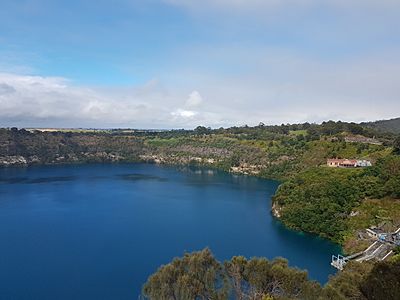
Blue Lake / Warwar
-
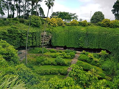
Umpherston Sinkhole / Balumbul


Service Industries and Shopping
As a major service center, Mount Gambier has several shopping areas. These include the Commercial Street CBD. Mount Gambier Marketplace opened in 2012. It is one of three main shopping centers. The others are Mount Gambier Central and the Coles shopping complex. The Coles complex opened in 2020.
Arts and Culture

The city's civic centre is in the old town hall building. It has been renovated and expanded. This building used to be a cinema in the 1950s.
The city's arts hub is near Cave Gardens. It includes the Riddoch Art Gallery. This is South Australia's main regional art gallery. It also houses the University of South Australia's James Morrison Academy. In 2011, the complex was expanded to include "The Main Corner." This modern building has a theatre. Nearby are the public library and a cafe.
Music Events
Each year, Mount Gambier hosts the Generations in Jazz Festival. Nearly 7,000 high school musicians attend. Famous jazz artists like James Morrison perform and judge the competition. Past special guests include Gordon Goodwin and his Big Phat Band.
Media and News
Newspapers
The local newspaper for Mount Gambier is The Border Watch. It covers the Limestone Coast and South East region. It is published from Tuesday to Friday. Major newspapers from Melbourne and Adelaide are also available. National newspapers like The Australian can also be bought.
Television
Mount Gambier receives television services from several networks:
- The Australian Broadcasting Corporation (ABC) – ABC, ABC TV Plus/ABC Kids, ABC Me, ABC News.
- The Special Broadcasting Service (SBS) – SBS, SBS Viceland, SBS World Movies, SBS Food, SBS WorldWatch, NITV.
- WIN Television (7, 9 & 10) – These channels show programs from Seven Network, Nine Network, and Network 10.
- Foxtel – This is a paid TV service available by satellite.
Local news programs for Mount Gambier stopped in 2013. Many people in Mount Gambier can also watch TV from Western Victoria. This is because the city is close to the state border.
Radio
Mount Gambier has several radio stations:
- ABC
- ABC South East SA (1476 AM)
- ABC Triple J (102.5 FM)
- ABC Radio National (103.3 FM)
- ABC Classic FM (104.1 FM)
- ABC NewsRadio (105.7 FM)
- Commercial
- Radio TAB
- Triple M Limestone Coast (90.5 FM)
- SAFM (96.1 FM)
- 5GTR FM (100.1 FM)
- LIME FM (104.9 FM)
Sports in Mount Gambier
.jpg)
There are four Australian rules football teams in the Western Border Football League:
- North Gambier
- East Gambier
- South Gambier
- West Gambier
Many AFL players have come from Mount Gambier. These include David Marshall and Nick Daffy.
Mount Gambier also has many other sports clubs and leagues. These include soccer, netball, basketball, tennis, hockey, cricket, swimming, cycling, and golf.
Motor sport is very popular. The main places for racing are the McNamara Park road racing circuit and the Borderline Speedway. Borderline Speedway is a 372-meter (407-yard) dirt track oval. It is nicknamed "The Bullring." It hosts an annual Sprintcar event called the "Kings Challenge." This race happens in January.
Mount Gambier is also home to "The Alex Roberts 100 Mile Classic." This is a cycling event. It is the longest running open cycling event in South Australia.
The Mount Gambier Greyhound Racing Club holds greyhound racing meetings. They race at Tara Raceway.
City Services and Education
Education in Mount Gambier
Mount Gambier has several schools:
- Primary Schools (Reception to Year 6):
* Reidy Park Primary School * McDonald Park * Compton Primary School * Melaleuca Park * Mulga Street Primary School * Mount Gambier North Primary School
- Colleges (Reception to Year 12):
* Tenison Woods College * St Martins Lutheran College
- High Schools (Year 7 to 12):
* Mount Gambier High School * Grant High School
For education after high school, there are:
- TAFE South Australia: Offers many vocational courses.
- University of South Australia: Has a modern campus. It offers degrees in Education, Nursing, and Social Work.
- Flinders University: Operates Flinders Rural Health SA at the Mount Gambier Hospital.
Getting Around Mount Gambier
Mount Gambier is connected to other towns by several highways:
- Princes Highway (Jubilee Highway) goes through the city from east to west.
 leads to Melbourne.
 leads to Adelaide.
- Riddoch Highway (Penola / Bay Road) goes through the city from north to south.
 leads to Adelaide.
 leads to Port Macdonnell.
The Mount Gambier Airport is a few kilometers north of the city. Rex Airlines flies to Adelaide and Melbourne from here. Qantas also offers daily flights to Adelaide and Melbourne.
Stateliner runs bus services to Mount Gambier from Adelaide. V/Line runs a daily bus service from Mount Gambier to Warrnambool, Victoria. This bus connects to a train service to Melbourne.
Famous People from Mount Gambier
Many notable people were born or lived in Mount Gambier, including:
- Kai Allen (born 2005), a racing driver.
- Kasey Chambers (born 1976), a singer.
- Robert Helpmann (1909-1986), a famous dancer and choreographer.
- Gavin Wanganeen (born 1973), an AFL Footballer.
- David Marshall, an Australian rules footballer.
- Tony Pasin, a politician.
- Allan Scott, a well-known businessman.
- Josip Skoko, a Socceroo (Australian soccer player).
- Matthew Clarke, an Australian rules footballer.
- Nick Daffy, an Australian rules footballer.
- Brad Close, an Australian rules footballer.
Images for kids
-
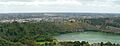
View north across Valley Lake and Marist Park to the eastern urban area of Mount Gambier from Centenary Tower
Contents |
See also
 In Spanish: Mount Gambier para niños
