Yongala, South Australia facts for kids
Quick facts for kids YongalaSouth Australia |
|||||||||||||||
|---|---|---|---|---|---|---|---|---|---|---|---|---|---|---|---|

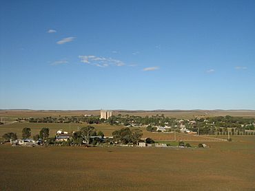
Scene from the hill overlooking Yongala
|
|||||||||||||||
| Postcode(s) | 5493 | ||||||||||||||
| Elevation | 512 m (1,680 ft) | ||||||||||||||
| Location |
|
||||||||||||||
| LGA(s) | District Council of Peterborough | ||||||||||||||
| County | Dalhousie | ||||||||||||||
| State electorate(s) | Stuart | ||||||||||||||
| Federal Division(s) | Grey | ||||||||||||||
|
|||||||||||||||
|
|||||||||||||||
Yongala is a small town in South Australia, Australia. It is located on the Clare-Peterborough Road (B79). The town is about 238 kilometers (148 miles) north of Adelaide, which is the capital city of South Australia.
Contents
What's in a Name? The Meaning of Yongala
The name Yongala comes from an Aboriginal phrase. It might mean "good water place" or "brother." Another idea, "broad water," is probably not correct.
A Look Back: Yongala's History
In 1871, the area around Yongala was opened up for people to settle and farm. This was part of a plan to encourage more people to live there. The town of Yongala was officially created on May 23, 1876.
Many people moved to Yongala, and by 1881, there were 353 residents. They hoped a railway line would be built through the town. However, the railway was built through the nearby town of Peterborough instead.
A famous ship, the SS Yongala, was named after this town. It was launched in 1903. Sadly, the ship sank in a storm in 1911 near Townsville, Queensland. The place where the ship sank is now protected by law.
Yongala's Weather and Location
Yongala has a type of weather called a cold semi-arid climate. This means it's usually dry, but it can get quite cold, especially in winter. The town is located on a high flat area called a plateau, which is about 512 meters (1,680 feet) above sea level. Because it's so high, it can even snow in Yongala during winter!
Yongala holds some records for being the coldest place in South Australia. For example, the lowest temperature ever recorded there was a very chilly -8.2°C (17.2°F) on July 20, 1976. It also holds the record for the lowest temperatures in South Australia for the months of May, June, August, and September.
| Climate data for Yongala (1926–2022, rainfall to 1881); 521 m AMSL; 33.03° S, 138.76° E | |||||||||||||
|---|---|---|---|---|---|---|---|---|---|---|---|---|---|
| Month | Jan | Feb | Mar | Apr | May | Jun | Jul | Aug | Sep | Oct | Nov | Dec | Year |
| Record high °C (°F) | 43.5 (110.3) |
44.0 (111.2) |
39.5 (103.1) |
36.0 (96.8) |
27.6 (81.7) |
23.3 (73.9) |
25.6 (78.1) |
28.2 (82.8) |
32.8 (91.0) |
37.8 (100.0) |
41.8 (107.2) |
41.5 (106.7) |
44.0 (111.2) |
| Mean daily maximum °C (°F) | 30.9 (87.6) |
30.1 (86.2) |
27.2 (81.0) |
22.0 (71.6) |
17.1 (62.8) |
13.6 (56.5) |
12.9 (55.2) |
14.5 (58.1) |
18.0 (64.4) |
22.0 (71.6) |
25.8 (78.4) |
28.7 (83.7) |
21.9 (71.4) |
| Mean daily minimum °C (°F) | 13.7 (56.7) |
13.5 (56.3) |
10.9 (51.6) |
7.3 (45.1) |
4.7 (40.5) |
2.9 (37.2) |
2.2 (36.0) |
2.6 (36.7) |
4.0 (39.2) |
6.2 (43.2) |
9.3 (48.7) |
11.7 (53.1) |
7.4 (45.4) |
| Record low °C (°F) | 2.6 (36.7) |
3.7 (38.7) |
1.1 (34.0) |
−2.5 (27.5) |
−6.6 (20.1) |
−8.1 (17.4) |
−8.2 (17.2) |
−6.0 (21.2) |
−4.5 (23.9) |
−3.0 (26.6) |
−2.0 (28.4) |
1.3 (34.3) |
−8.2 (17.2) |
| Average precipitation mm (inches) | 22.9 (0.90) |
20.8 (0.82) |
16.2 (0.64) |
25.0 (0.98) |
34.5 (1.36) |
39.0 (1.54) |
38.7 (1.52) |
42.6 (1.68) |
37.9 (1.49) |
33.0 (1.30) |
28.4 (1.12) |
24.6 (0.97) |
363.7 (14.32) |
| Average precipitation days (≥ 0.2mm) | 3.7 | 3.4 | 3.8 | 5.7 | 9.6 | 11.8 | 13.0 | 12.8 | 9.7 | 8.1 | 6.3 | 5.0 | 92.9 |
| Average afternoon relative humidity (%) | 25 | 29 | 31 | 39 | 51 | 59 | 60 | 55 | 45 | 36 | 30 | 28 | 41 |
| Source: Bureau of Meteorology | |||||||||||||
See also
 In Spanish: Yongala para niños
 | DeHart Hubbard |
 | Wilma Rudolph |
 | Jesse Owens |
 | Jackie Joyner-Kersee |
 | Major Taylor |


