Goolwa, South Australia facts for kids
Quick facts for kids GoolwaSouth Australia |
|||||||||||||||
|---|---|---|---|---|---|---|---|---|---|---|---|---|---|---|---|

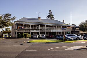
"Australasian Hotel" building in Goolwa built in the Georgian architectural style, typical of the main street
|
|||||||||||||||
| Population |
|
||||||||||||||
| Established | 1853 | ||||||||||||||
| Postcode(s) | 5214 | ||||||||||||||
| Location | 85 km (53 mi) from Adelaide | ||||||||||||||
| LGA(s) | Alexandrina Council | ||||||||||||||
| Region | Fleurieu and Kangaroo Island | ||||||||||||||
| State electorate(s) | Finniss | ||||||||||||||
| Federal Division(s) | Mayo | ||||||||||||||
|
|||||||||||||||
|
|||||||||||||||
| Footnotes | Climate Adjoining localities |
||||||||||||||
Goolwa, also known as The Elbow by early settlers, is a historic river port town. It is located on the Murray River in South Australia, close to where the river meets the sea at the Murray Mouth. Goolwa is about 85 kilometers (53 miles) south of Adelaide. A bridge connects it to Hindmarsh Island.
Contents
Goolwa's Fascinating History
The name "Goolwa" comes from the Ngarrindjeri language. It means "elbow," which is why early settlers called the area "The Elbow."
In the early days, before 1837, people even thought about making Goolwa the capital city of the colony. A survey was done in 1839–40. It planned a large town at Currency Creek. It also included a port with big warehouses where Goolwa is today.
A wharf was built in 1852, and government buildings followed quickly. This included a post office in 1853. However, the dangerous waters of the Murray Mouth made it hard for large ships. This meant Goolwa could not become a major shipping port.
Australia's First Inland Port
Even so, Goolwa became Australia's first inland port in 1853. To help move goods, Australia's first railway opened in 1854. This railway connected Goolwa to Port Elliot. Later, it was extended to Victor Harbor. This allowed goods to be moved easily from river boats to ocean ships. This way, neither had to deal with the tricky Murray Mouth. Goolwa was officially established as a town in 1857.
Over time, more railways were built across Australia. This made river trade less important. Goolwa's role as a major port slowly ended. The town then began to rely on local farming and fishing. It also became a popular holiday spot for people from Adelaide.
Protecting the River
In 1935, a permanent barrage was built. It is called the Goolwa Barrage. This structure is between Hindmarsh Island and Sir Richard Peninsula. Its main job is to keep the fresh water of the Murray River separate. It stops the salt water from the Murray Mouth from flowing upstream. This protects the river's fresh water supply.
Goolwa was first connected to Hindmarsh Island by a cable ferry. In 2001, a new bridge, the Hindmarsh Island bridge, was officially opened. Building this bridge was a big topic of discussion in the 1990s.
Dealing with Drought
Between 2008 and 2009, Goolwa faced one of Australia's worst droughts. The river, which had always supported the town, became very low. It was mostly just a channel with mudflats. This crisis led to talks with the government. The goal was to get more water released from upstream to save the river.
In 2009, a temporary levee was built. It was called the Clayton Regulator. This regulator was placed between Clayton Bay and Hindmarsh Island. Its purpose was to protect the Goolwa Channel. It prevented dangerous acid sulfate soils from forming. The low water level was exposing the riverbed. Scientists warned that this could make the Lower Lakes region very acidic. The Regulator immediately raised the water level between itself and the Goolwa Barrage.
By 2010, more rain and water from upstream helped the river recover. The Regulator at Clayton Bay was mostly removed. The river and lower lakes filled up again. In late 2010, some gates on the Goolwa Barrage were opened. This was the first time in many years. It allowed fresh water to flow out to the Murray Mouth. Even more rain and floods from New South Wales and Victoria followed. By January 2011, all the gates on the Goolwa Barrage were open.
Goolwa's Location and Government
Goolwa is about 85 kilometers (53 miles) south of Adelaide. It is the main town for the Alexandrina Council. This means the local government offices are located here.
Goolwa is part of the state electoral district of Finniss. It is also in the federal Division of Mayo. In 2011, the population of Goolwa (not including Goolwa Beach, Goolwa North, and Goolwa South) was 2,201 people. By June 2018, the estimated population for Goolwa and nearby Victor Harbor combined was 26,532. The part of this population living in Goolwa was 11,578.
Fun Things to Do in Goolwa
Goolwa is a popular place for holidays and fun activities.
- South Australian Wooden Boat Festival: Every two years, Goolwa hosts this exciting festival. You can see many beautiful wooden boats.
- PS Oscar W: The town is home to the PS Oscar W, a historic paddle steamer. You can often see it on the river.
Goolwa, along with nearby towns like Middleton and Port Elliot, and the city of Victor Harbor, has become very popular. Many people are moving here from bigger cities. They are looking for a better lifestyle by the coast, often called a "sea change."
In March 2007, Goolwa was given a special title: a Cittaslow town. This means it's part of a movement that promotes a "slow city" lifestyle. It focuses on local traditions, good food, and a relaxed pace of life. Goolwa was the first town outside of Europe to become a Cittaslow.
On January 22, 2010, Goolwa was the finish line for the 4th stage of the 2010 Tour Down Under. This is a big cycling race. On that day, over 8,000 cyclists rode into Goolwa as part of a related event.
Learning About Water: CLLMM Research Centre
In early 2024, a new research center opened in Goolwa. It's called the Coorong, Lower Lakes and Murray Mouth (CLLMM) Research Centre. It is run by the Goyder Institute for Water Research. You can find it between the Hindmarsh Island bridge and the barrage.
This center focuses on studying and dealing with the effects of climate change in the region. They use both traditional knowledge from First Nations people and modern scientific methods.
Goolwa's Climate
Goolwa has a warm-summer Mediterranean climate. This means it has warm, dry summers and mild, wetter winters.
- Temperatures: The average highest temperature is around 24.4°C (75.9°F) in February. The average lowest temperature is about 7.6°C (45.7°F) in July.
- Rainfall: Goolwa gets about 442.2 millimeters (17.4 inches) of rain each year. Most of the rain falls during the winter months.
- Sunny Days: The town has about 46 clear, sunny days each year. It also has about 181 cloudy days.
| Climate data for Goolwa (Hindmarsh Island Marina) (35º30'36"S, 138º48'00"E, 3 m AMSL) (1989-2003 normals and extremes) | |||||||||||||
|---|---|---|---|---|---|---|---|---|---|---|---|---|---|
| Month | Jan | Feb | Mar | Apr | May | Jun | Jul | Aug | Sep | Oct | Nov | Dec | Year |
| Record high °C (°F) | 43.0 (109.4) |
41.3 (106.3) |
39.1 (102.4) |
35.4 (95.7) |
28.9 (84.0) |
25.5 (77.9) |
22.9 (73.2) |
27.0 (80.6) |
31.4 (88.5) |
34.7 (94.5) |
41.5 (106.7) |
41.2 (106.2) |
43.0 (109.4) |
| Mean daily maximum °C (°F) | 23.6 (74.5) |
24.4 (75.9) |
22.1 (71.8) |
20.6 (69.1) |
18.1 (64.6) |
15.8 (60.4) |
15.4 (59.7) |
16.0 (60.8) |
18.0 (64.4) |
19.9 (67.8) |
21.2 (70.2) |
21.9 (71.4) |
19.7 (67.6) |
| Mean daily minimum °C (°F) | 15.4 (59.7) |
15.5 (59.9) |
13.9 (57.0) |
11.8 (53.2) |
9.7 (49.5) |
8.4 (47.1) |
7.6 (45.7) |
7.7 (45.9) |
9.0 (48.2) |
10.5 (50.9) |
12.4 (54.3) |
13.9 (57.0) |
11.3 (52.4) |
| Record low °C (°F) | 7.8 (46.0) |
9.1 (48.4) |
7.4 (45.3) |
5.0 (41.0) |
1.2 (34.2) |
0.6 (33.1) |
2.0 (35.6) |
1.0 (33.8) |
3.4 (38.1) |
4.3 (39.7) |
5.8 (42.4) |
7.0 (44.6) |
0.6 (33.1) |
| Average precipitation mm (inches) | 12.8 (0.50) |
14.4 (0.57) |
18.6 (0.73) |
27.7 (1.09) |
41.0 (1.61) |
59.8 (2.35) |
60.5 (2.38) |
53.0 (2.09) |
50.6 (1.99) |
40.6 (1.60) |
27.8 (1.09) |
30.4 (1.20) |
442.2 (17.41) |
| Average precipitation days (≥ 0.2 mm) | 5.2 | 4.5 | 7.4 | 10.0 | 15.8 | 18.1 | 19.9 | 17.8 | 14.9 | 12.7 | 9.9 | 8.1 | 144.3 |
| Average afternoon relative humidity (%) | 67 | 65 | 65 | 64 | 66 | 71 | 71 | 64 | 65 | 62 | 63 | 65 | 66 |
| Average dew point °C (°F) | 13.9 (57.0) |
13.9 (57.0) |
12.8 (55.0) |
11.1 (52.0) |
9.9 (49.8) |
9.1 (48.4) |
8.6 (47.5) |
7.6 (45.7) |
9.2 (48.6) |
9.3 (48.7) |
10.8 (51.4) |
12.4 (54.3) |
10.7 (51.3) |
| Source: Bureau of Meteorology (1989-2003 normals and extremes) | |||||||||||||
 | William L. Dawson |
 | W. E. B. Du Bois |
 | Harry Belafonte |


