
Pearson Isles facts for kids

Pearson Isles
Location in South Australia
|
|
| Geography | |
|---|---|
| Location | Great Australian Bight |
| Coordinates | 33°57′39″S 134°15′54″E / 33.96089°S 134.265°E |
| Administration | |
The Pearson Isles are a group of islands in South Australia. They are also known as the Pearson Islands, Pearson Group, or Pearson Archipelago. These islands are about 65 to 72 kilometers west-south-west of Cape Finniss. This cape is on the west coast of the Eyre Peninsula.
The famous explorer Matthew Flinders discovered and named these islands on February 13, 1802. The group includes four main parts: Pearson Island, two islands called the Veteran Isles, and Dorothee Island. The Pearson Isles have been a protected area since 1916. Since 2011, they have been part of the Investigator Group Wilderness Protection Area. Scientists often visit these islands to do research.
Contents
About the Islands
.jpeg)
The Pearson Isles are located in the ocean off the coast of South Australia. They are about 65 to 72 kilometers from Cape Finniss. The islands are Pearson Island, Veteran Isles, and Dorothee Island. They are listed in order from closest to farthest from the mainland.
Pearson Island: The Main Island
Pearson Island is about 63 kilometers south-west of Cape Finniss. It is also about 25 kilometers south-west of Flinders Island. This island has one large land mass. It also has two smaller peaks that rise out of the sea. These peaks form an arc to the south-east. A narrow strip of rock, called a spit, connects them.
This arc creates a sheltered bay and a beach. These spots are safe from strong winds and waves. They can be used for anchoring boats and landing on the island. People sometimes call the three parts of the island the "north section," "middle section," and "south section."
Pearson Island covers an area of 213 hectares. Its highest point is "Hill 781," which is 238 meters above sea level. Two other hills, "North Hill" and "East Hill," are also over 200 meters high. These are all on the "north section." The highest point on the "south section" is "South Hill," at 115 meters.
Veteran Isles: A Pair of Peaks
The Veteran Isles are two peaks located about 1 kilometer south of Pearson Island. They are about 0.5 kilometers apart. The northern island is 82 meters high. The southern island is between 25 and 26 meters high. Together, both islands cover about 14 hectares.
The northern island has small areas of soil. This soil supports a type of shrubland on its higher parts. The southern island has no soil or plants. This is because of strong wave action. Landing a boat here can be difficult. The steep shoreline and sea conditions make it risky unless the water is very calm.
Dorothee Island: Eroded Beauty
Dorothee Island is about 4 kilometers south of Pearson Island. It covers an area of about 56 hectares. This island has been heavily eroded over time. A large crack, called a crevasse, cuts across the island from east to west. This crevasse creates two peaks.
The north side of the island reaches 140 meters high. The south side is 102 meters high. The tops of both peaks have some soil. This soil is mostly coarse and rocky. However, there are also small patches of sandy soil. The east coast of the island offers some shelter. This allows for careful landings, unless the ocean swells are very big.
How the Islands Were Formed
The Pearson Isles were formed about 10,500 years ago. This happened when sea levels rose at the start of the Holocene period. The four islands are actually the tops of a large rock formation. This formation is called an inselberg. An inselberg is like a mountain that stands alone. Over time, the sea level rose and covered most of it.
The main rock of the islands is granite. This granite is part of a group of rocks from a huge volcanic event. This event happened about 1,590 million years ago. It affected the area that is now the western Eyre Peninsula and parts of the Great Australian Bight.
The landforms on each island are shaped by two main things. First, the granite rock itself and how it breaks. Second, the ocean and how it erodes the land. For example, you can see large, curved rock sheets on the lower parts of the islands. On the higher parts, there are boulders that broke off these sheets. There are also signs of old sand dunes from a time when the sea level was much lower.
The water around the Pearson Isles gets very deep quickly. It drops to more than 50 meters deep within 500 meters of Pearson Island's coast. The same happens on the south and west sides of Dorothee Island.
History of the Islands
European Discovery
Matthew Flinders discovered and named the Pearson Isles on February 13, 1802. On the same day, he included them as part of the larger Investigator Group of islands. Flinders described the islands as having "two high and sharp-pointed peaks." He thought they might be several small islands, or perhaps two or three larger ones, or even one connected landmass.
Naming the Islands
Flinders never said why he chose the name "Pearson." There are a few ideas about where the name came from.
- One idea is that it was named after Flinders' brother-in-law. However, his sister did not marry Mr. Pearson until 1806. This means the islands might have been named later.
- Another idea is that it was named after the mother of Flinders' second-in-command, Robert Merrick Fowler. Her maiden name was Pearson. The South Australian government often uses this explanation.
- A third idea is Sir Richard Pearson, a Royal Navy officer. He was known for his role in the Battle of Flamborough Head.
The Baudin expedition visited the islands later in 1802. Nicolas Baudin suggested the name "Les Enfans Perdus," which means "The Lost Children." Louis de Freycinet's map used "Is du Veteran" (Veteran Isles). He also suggested "Ile Dorothee" (Dorothee Island) for one of the islands.
In 1969, the South Australian government officially adopted the English versions of these French names. This is why we have "Veteran Isles" and "Dorothee Island" today.
Past Uses of the Islands
Pearson Island was briefly used for sheep grazing in the 1800s. A man named Anton Schlink tried to raise sheep there. But it didn't work well. The island was too rocky and dry. It was also hard to manage the sheep.
The waters around the islands have been used for commercial fishing, recreational fishing, and recreational diving.
Scientific Research on the Islands
Scientists have been interested in the Pearson Isles since the early 1900s. They study the islands' geology, plants, and animals. The islands are a great place for research because they are far away and not many people visit them. Also, there are no introduced pests, which helps keep the natural environment safe.
Since 1968, there has been a navigation aid on the middle part of Pearson Island. It is a 2-meter-high tower. It has a flashing light that is 79 meters above sea level. This light helps ships navigate safely.
Protected Status
The Pearson Isles first became a protected area on July 27, 1916. This was to protect the black-footed rock wallaby population on Pearson Island. Later, in 1967, they were made a fauna conservation reserve.
In 1972, the island group became part of the Investigator Group Conservation Park. This was done to protect the delicate island environment. It also protected areas where Australian sea lions and New Zealand fur seals rest. On August 25, 2011, the Pearson Isles became part of the Investigator Group Wilderness Protection Area.
Since 2012, the waters around the Pearson Isles have been a sanctuary zone. This means they are a special protected area within the Investigator Marine Park.
Images for kids
-
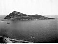
A distant view of the Pearson Isles off the west coast of Eyre Peninsula
See also
 In Spanish: Islas Pearson para niños
