Nuriootpa, South Australia facts for kids
Quick facts for kids NuriootpaSouth Australia |
|||||||||||||||
|---|---|---|---|---|---|---|---|---|---|---|---|---|---|---|---|

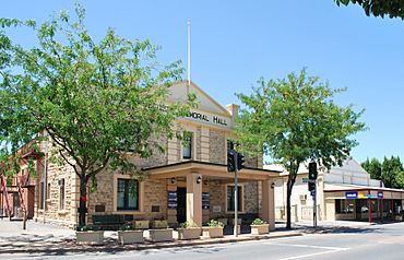
Memorial hall
|
|||||||||||||||
| Established | 1854 | ||||||||||||||
| Postcode(s) | 5355 | ||||||||||||||
| Location | 74 km (46 mi) North East of Adelaide via |
||||||||||||||
| LGA(s) | Barossa Council, Light Regional Council | ||||||||||||||
| State electorate(s) | Schubert | ||||||||||||||
| Federal Division(s) | Barker | ||||||||||||||
|
|||||||||||||||
|
|||||||||||||||
Nuriootpa is a town in South Australia. It is the main business centre of the Barossa Valley. The town is about an hour's drive north of Adelaide, the state capital. The name 'Nuriootpa' is believed to be an Aboriginal word meaning "meeting place".
Nuriootpa is located at the northern end of the Barossa Valley, close to the Sturt Highway. It is the largest town in the area, with over 6,500 people living there. Many vineyards surround the town. It is home to famous wineries like Penfolds, Elderton Wines, and Wolf Blass.
Contents
A Look Back: Nuriootpa's History
The first Europeans to visit the Nuriootpa area were explorers on March 3, 1838. They were on their way to the Murray River from Adelaide. These explorers included John Hill and John Jackson Oakden.
How Nuriootpa Built Its Community
Since the 1930s, Nuriootpa has been known for its amazing community spirit. The town has businesses that are owned and run by the community. The money made from these businesses helps pay for public places. These include the Senior Citizens' Club, the swimming pool, the kindergarten, and sports areas.
In 1944, a group called the Common Cause Movement brought Ben Chifley to Nuriootpa. He later became Australia's Prime Minister. He was so impressed by Nuriootpa's community teamwork that he suggested other towns follow its example. An architect named Louis Laybourne-Smith even designed a plan for the town's recreation and education area. This area was called the 'War Memorial Community Centre'. Many parts of his plan, like the unique 'fan-shaped' Olympic-sized swimming pool, were built.
Nuriootpa and Motor Racing
In January 1950, the 1950 Australian Grand Prix was held in Nuriootpa. This was Australia's biggest motor race that year. It used a temporary track made from roads in and around the town. Doug Whiteford won the race in his Ford V8 Special. The first race meeting on this circuit happened in April 1949.
Royal Visit to Nuriootpa
In March 1977, Queen Elizabeth II visited Nuriootpa. Her visit was part of a special tour to celebrate her Silver Jubilee.
Nuriootpa Hosts a Cycling Race
In January 2014, Nuriootpa hosted the first part of the 2014 Tour Down Under. This is a big cycling race. The 135 km stage started in Nuriootpa and ended in Angaston. Simon Gerrans won this stage.
Who Governs Nuriootpa?
Most of Nuriootpa is governed by the Barossa Council. Some parts on the northern edge are in the Light Regional Council.
For state elections, Nuriootpa is in the Schubert area. For federal elections, it is part of the Electorate of Barker.
What Facilities Does Nuriootpa Have?
Nuriootpa is home to Nuriootpa High School (NHS). It opened in 1935 and teaches students from years 7 to 12. As of 2023, more than 1300 students attend the school. Its motto is "PER ASPERA AD ASTRA," which means "Through Adversity to the Stars."
Nuriootpa in the News
The main local newspaper for Nuriootpa is The Leader. It is published in Angaston.
Nuriootpa's Climate
Nuriootpa has a hot-summer Mediterranean climate. This means it has very warm, dry summers and cool, somewhat wet winters. The average highest temperature in January is about 30.2°C, and in July it's around 13.6°C. The town gets about 474.8 mm of rain each year, mostly in winter.
 | Bessie Coleman |
 | Spann Watson |
 | Jill E. Brown |
 | Sherman W. White |


