
Geography of South Australia facts for kids
Quick facts for kids Geography of South Australia |
|
|---|---|
 |
|
| Continent | Australia |
| Coordinates | 30°S 135°E / 30°S 135°E |
| Area | Ranked 4th among states and territories |
| • Total | 984,321 km2 (380,048 sq mi) |
| • Land | 94.25% |
| • Water | 5.75% |
| Coastline | 3,815 km (2,371 mi) |
| Borders | Land borders: Western Australia, Northern Territory, Queensland, New South Wales, Victoria |
| Highest point | Mount Woodroffe 1,435 m (4,708 ft) |
| Lowest point | Lake Eyre -15 m (49 ft) |
| Longest river | Murray River 683 km (424 mi) |
| Largest lake | Lake Eyre 9690 km2 |
The geography of South Australia is all about the land, water, and features of this amazing part of Australia. It's one of the six states that make up the country. South Australia is located in the south-central part of the continent.
It shares its borders with many other places. To the west, you'll find Western Australia. To the north, it meets the Northern Territory. On the northeast side, it touches Queensland. And to the east, it borders both New South Wales and Victoria. The southern edge of South Australia is next to the Great Australian Bight and the big Southern Ocean.
Contents
Land and Landscapes
Dry North and West
The northern and western parts of South Australia are very dry, like a desert. This area is part of central Australia. Here, you'll find huge, mostly dry salt lakes like Lake Eyre and Lake Torrens.
Not many people live in these dry areas. Instead, there are many large cattle stations, which are huge farms for raising cattle. There are also important national parks and lands that belong to Aboriginal people.
The main roads through these dry lands are the Stuart Highway, which goes north from Port Augusta to the Northern Territory. The Eyre Highway crosses the flat Nullarbor Plain to Western Australia. The Barrier Highway goes east to Broken Hill in New South Wales. These highways also have train lines running alongside them, like the Trans-Australian Railway and the Adelaide–Darwin railway.
Coastal Areas
South Australia has a long and interesting coastline. Along the Great Australian Bight, you can see tall cliffs, especially on the western side of the Eyre Peninsula.
The coast is a bit flatter around Spencer Gulf and Gulf St Vincent. These two gulfs are separated by the Yorke Peninsula. Other coastal areas include the Fleurieu Peninsula, Encounter Bay, and a special wetland area called The Coorong. East of Gulf St Vincent, the land is covered by Temperate Grassland of South Australia.
Mountains and Hills
The highest point in South Australia is Mount Woodroffe. It stands tall at 1,435 metres (about 4,708 feet) in the Musgrave Ranges, located in the northwest corner of the state.
The main mountain ranges are the Mount Lofty Ranges and the Flinders Ranges. These ranges stretch for about 800 kilometres (500 miles). They run along the eastern sides of Gulf St Vincent and Spencer Gulf. About half of South Australia is less than 150 metres (492 feet) above sea level.
Deserts and Farming Land
A special line called Goyder's Line separates the dry north from the more fertile southeast. This line was first mapped in the 1860s. It has been very accurate in showing where farmers can successfully grow crops and raise animals.
South Australia is home to three deserts: the Great Victoria Desert, the Strzelecki Desert, and the Sturt Stony Desert.
The Murray River
East of the Mount Lofty Ranges, the Murray River flows into South Australia from New South Wales and Victoria. It then turns south, running next to the ranges. The Murray River is very important because it's the only large, permanent river in the entire state.
Climate


South Australia has different types of weather depending on where you are. The southern parts of the state have a Mediterranean climate. This means they have warm, dry summers and mild, wet winters, similar to places like California or parts of Europe.
The rest of the state, especially the northern and central areas, has a much drier arid climate or semi-arid climate. This means it's often hot and dry with very little rain.
Temperatures and Records
The average temperature in South Australia changes a lot between summer and winter. In January (summer), the average temperature is around 29 °C (84 °F). In July (winter), it's cooler, around 15 °C (59 °F).
During January and February, some parts of the state can get extremely hot, with daily temperatures reaching as high as 48 °C (118 °F)! The highest temperature ever recorded in South Australia, and in all of Australia, was 50.7 °C (123.3 °F). This happened in Oodnadatta on January 2, 1960.
On the other hand, the coldest temperature ever recorded in South Australia was -8.2 °C (17.2 °F). This freezing temperature was noted in Yongala on July 20, 1976.
Images for kids
-
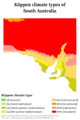
Different climate types in South Australia
-
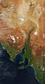
Satellite view of eastern South Australia. Notice the white patches, which are dry lakes.
