
Wardang Island facts for kids
|
Native name:
Wauraltee
|
|
|---|---|

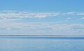
Wardang Island viewed from Port Victoria
|
|

Wardang Island
Location in South Australia
|
|
| Geography | |
| Location | Spencer Gulf |
| Coordinates | 34°30′S 137°22′E / 34.500°S 137.367°E |
| Administration | |
|
Australia
|
|
Wardang Island, also known as Wauraltee, is a flat island in the Spencer Gulf in South Australia. It is about 20 square kilometers in size. The island is close to the western coast of the Yorke Peninsula.
Wardang Island acts like a natural wall, protecting the old grain port of Port Victoria. It creates a safe place for ships to anchor. Over time, the island has been used for sheep farming and for studying rabbit diseases. People also dug for lime there. Today, the island is leased to its original owners, the Narungga people.
The smaller Goose Island and other small rocks are near the northern end of Wardang Island. These are part of the Goose Island Conservation Park. If you want to visit Wardang Island, you need to get permission first. You can ask the Point Pearce Community Council.
Contents
Understanding Wardang Island's Names
Both names for the island come from local Indigenous languages. The name Wardang means "crow." The name Wauraltee means "bandicoot island."
Wardang Island's Past
.jpg)
Wardang Island is a special part of the traditional lands of the Narungga people. They lived on the Yorke Peninsula. The Narungga people often camped on the island. They hunted and gathered food there, like shellfish, fish, and seabird eggs. They also held important ceremonies and burials on the island.
After Europeans settled in South Australia, the first lease for Wardang Island was given in 1861. Stephen Goldsworthy received it for 14 years. People cleared the natural plants and grew new grass for animals.
The lease made sure the Narungga people could still travel to and from the island. In 1884, Goldsworthy gave the lease to the Point Pearce Aboriginal Mission. This was for the benefit of all people in the area.
The mission used the island to raise sheep. They built shearing sheds and homes for families living there. Later, people also dug for lime on the island.
In 1877, Wardang Island was thought about as a place for a permanent quarantine station. This would be a place to keep sick people separate. But it was not chosen in the end. The Aboriginal reserve on the island was removed for a time in the early 1900s. It was completely ended in 1948.
Lighthouses and Shipwrecks
In 1909, a lighthouse was built on the west coast of Wardang Island. It was placed on the highest point. This helped guide the many ships coming to Port Victoria. But sometimes, it was hard to see the light.
In 1918, a different lighthouse tower was moved to Wardang Island. It came from Wedge Island. This new tower replaced the old light, which was just on a post. In 1988, the light was changed to use solar power. The old tower was replaced with a new fiberglass hut.
Many ships have been lost or wrecked around Wardang Island. Between 1898 and 1929, at least 18 ships had problems there. Eleven of these ships were completely wrecked. In 1916, it was said that ten shipwrecks lined the island's coast. In 1926, a newspaper called Wardang Island "The Island of Wrecks."
Before 1950, it was reported that 22 shipwrecks had happened near the island. Because of all these lost ships, the waters around Wardang Island are popular for wreck diving. There is a special dive trail that shows eight of the nine known shipwrecks. These ships were part of the trade around Port Victoria in the early 1900s.
Some of the wrecked ships were smaller schooners and coastal steamers. They carried wheat and other goods. These include the Monarch, S.S. Australian, S.S. Investigator, MacIntyre, and Moorara. Other wrecks were larger ships that carried grain to Europe. These include the Aagot, Notre Dame D’Arvor, and Songvaar. The dive trail is also called the Wardang Island Maritime Heritage Trail.
Digging for Lime and Building a Community
In 1900, companies started getting permission to dig for minerals on the island. From 1910, a company called Broken Hill Associated Smelters (BHAS) slowly bought all these permissions. By 1939, they owned all the mining rights on the island.
Until 1968, BHAS dug for lime sand on the island. They shipped it by barge to Port Pirie. There, it was used as a flux in metal smelters. A flux helps metals melt and separate.
In 1915, BHP built a jetty to help ship the lime. By 1918, they were digging mostly at the southern end of the island. A railway line was built to move the lime from the south to the jetty in the north. At first, horses pulled the carts. Later, a kerosene-powered train was used. In the early 1950s, trucks replaced the railway. By 1951, 900,000 tons of lime had been dug from Wardang Island and sent to Port Pirie.
As more people came to live on the island, BHAS built homes, a school, and other things for their workers and families. In 1930, the island had two jetties, a dance hall, a school, a playground, and 14 houses. In 1950, 47 people lived on the island, including 14 schoolchildren. The BHAS foreman, Mr. J. W. Waters, had lived there the longest, for 13 years.
BHAS stopped digging for lime on Wardang Island when they found more lime in Coffin Bay. They gave up their leases and left the island. Another substance called Guano (bird droppings used as fertilizer) was also dug up on Wardang Island.
All digging stopped in 1968. Between 1910 and 1968, over a million tons of sand were removed from the island. The moving sand dune at the south of the island was completely taken away. Only the stable, plant-covered dunes remain.
Protecting and Restoring the Island
In 1969, Wardang Island became a place where animals are protected. It was called a fauna sanctuary.
In 1973, the island was named a Historic Reserve. Since then, it has been owned by the Aboriginal Lands Trust.
In 1996, Wardang Island was described as the "most damaged" of South Australia's large islands.
In 2014, the island was named an Indigenous Protected Area. This means it is managed by Indigenous people for conservation.
In 2019, a big project was announced to help the island recover. It received almost AUD$4 million in funding. The project involves tearing down old buildings and removing dangerous materials like asbestos. New buildings will be built for Indigenous Rangers to use.
Money from the government has helped the Aboriginal Lands Trust buy a barge. This will allow people to get to Wardang Island easily. The funding will also support the Indigenous Protected Area work. It will train Aboriginal people for jobs on the water. The barge will also be available for other uses.
The Government of South Australia has promised AUD$1.3 million to build a new landing place on the island. The Premier of South Australia, Steven Marshall, said that this would help bring tourists, especially shipwreck divers.
An organization called Greening Australia is planting new trees and plants on the island. Their goal is to bring back animals that used to live there but are now gone from the area. This includes the Western quoll.
Remember, you still need to get permission from the Point Pearce Community Council to visit the island.
Plants and Animals of Wardang Island
The native plants on Wardang Island include the Coast daisy-bush and Grey Samphire. Other native plants are some She-oaks and Umbrella wattle trees. Many of the wattle trees are small because rabbits eat them. There is also some Marsh saltbush. In 1996, people thought that the native reddish-purple Garland Lily might still be growing in the grasslands.
Many unwanted plants, called weeds, are found on the island. These include thick mats of Common Iceplant near the coast. Sea Spurge grows in salty areas. Clumps of African Boxthorn, Tree Tobacco, and Horehound are also present.
Emus live on the island. They were brought there in the 1970s for a short time, as part of a tourism idea.
All the mammals (animals that feed milk to their babies) on the island were brought there by people. In 1996, these included Tammar wallabies, rabbits, wild cats, two camels, and eight donkeys. Reptiles also live on the island.
Wardang Island is home to many seabirds. These include silver gulls, terns, oystercatchers, little penguins, and cormorants. The names of some places on the island show how important birds are there. For example, there's Pidgeon Rock and Bird Point. Snapper Point is named after a fish called snapper, which is caught nearby. Another fish caught off Wardang Island is the Australian herring, also known as Tommy Ruff.
In the past, the island had native bandicoots and wild turkeys.
Rabbits and Disease Research

Some people say that fishermen brought rabbits to the island around 1922. However, people were hunting rabbits on Wardang Island much earlier. In 1875, it was reported that the island was "full of rabbits." No one knows exactly when or how the rabbits first arrived.
In 1937, the Council for Scientific and Industrial Research started its first tests of a disease called myxomatosis on Wardang Island. This was a big step in controlling rabbits. They figured out how to release the myxoma virus across Australia in the early 1950s. This program was a very successful way to control pests using biology. It reduced Australia's wild rabbit population from 600 million to 100 million in just two years!
In 1995, new tests began on Wardang Island for another rabbit disease. This was the rabbit calicivirus, which causes rabbit haemorrhagic disease (RHD). In October of that year, the virus accidentally escaped from the island. It was thought that bushflies carried it to the mainland on the afternoon sea breezes. The virus quickly spread across the country. It caused many wild rabbits to die. But just like myxomatosis, it has not completely gotten rid of the rabbit problem.
Little Penguin Colony
Wardang Island used to have the second largest group of little penguins breeding in South Australia. It was the biggest group in the state's gulf waters. In 1938, a ship captain said that an Italian ship crashed on Wardang Island. The crew thought the sounds of the penguins were scary wild animals.
Penguins were known to be very common on the island in 1874. Visitors saw them in 1875 and 1895. In the 1920s and 1930s, Wardang Island was often described as home to many penguins. In 1937, it was even said that the island was "infested with thousands of penguins." In 1944, a newspaper described the penguin colony: "The north and north west coasts of the island have steep limestone cliffs. Strong westerly winds have worn away these cliffs. Large pieces of rock have fallen into the sea. Waves have shaped them into strange forms. Up on top, penguins are very many. They make their nests in shallow burrows. There are hundreds of such nests."
In 1946, Mr. Pim wrote about Wardang Island: "On the west coast... groups of penguins are happy to see anyone who wants to visit."
Their presence was noted in 1950 by Edna Davies. She said that if anyone visited the island and stayed until night, they would see and hear the penguins coming ashore. Penguins were also seen when Governor Norrie visited in 1950. In 1966, a visitor described seeing "hundreds" of little penguins on Wardang Island. In 1981, penguins were still thought to be very common. In 2004, it was thought that Wardang Island had about 8,000 penguins.
In 2005, the Point Pearce Community helped trap feral cats. This was done to stop the wild cats from hunting the little penguins. As of 2011, we don't know the exact number of penguins on the island. But in 1996, it was noted that their numbers seemed to be going down from how many there used to be.
Images for kids
-
Wardang Island viewed from Port Victoria
-
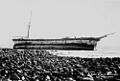
The remains of the Aagot, not long after it was wrecked in 1907
-
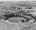
Rabbits at a waterhole during a myxomatosis trial on Wardang in 1938
