Groote Eylandt facts for kids

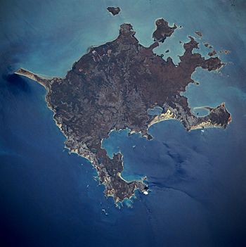
Groote Eylandt from space, November 1989
|
|
| Etymology | From the Dutch for "Large Island" |
|---|---|
| Geography | |
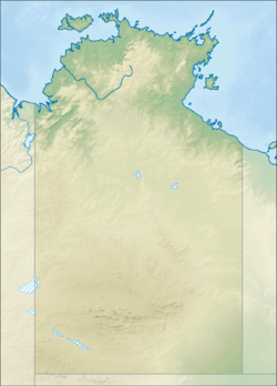
| Location | Gulf of Carpentaria |
| Coordinates | 13°58′S 136°35′E / 13.967°S 136.583°E |
| Area | 2,326.1 km2 (898.1 sq mi) |
| Length | 50 km (31 mi) |
| Width | 60 km (37 mi) |
| Highest elevation | 219 m (719 ft) |
| Highest point | Central Hill |
| Administration | |
|
Australia
|
|
| Territory | Northern Territory |
| Region | East Arnhem Region/ unincorporated Alyangula |
| Ward | Anindilyakwa Ward/ unincorporated Alyangula |
| Largest settlement | Alyangula (pop. 966) |
| Demographics | |
| Population | 2,811 (2016 census) |
| Pop. density | 1.21 /km2 (3.13 /sq mi) |
| Ethnic groups | Warnindhilyagwa |
Groote Eylandt is the biggest island in the Gulf of Carpentaria. It is also the fourth largest island in all of Australia. This special island is the home of the Warnindhilyagwa people. They own the land and speak the Anindilyakwa language.
Groote Eylandt is about 50 kilometers (31 miles) from the mainland of the Northern Territory. It's also about 630 kilometers (391 miles) from Darwin. The island is about 50 kilometers (31 miles) wide and 60 kilometers (37 miles) long. Its total area is about 2,326 square kilometers (898 square miles). Most of the island is low, about 15 meters (49 feet) above sea level. However, a spot called Central Hill reaches 219 meters (719 feet) high. The explorer Abel Tasman named the island in 1644. "Groote Eylandt" means "Large Island" in old Dutch.
Contents
Island Management
Groote Eylandt, along with Bickerton Island and other smaller islands, forms the Anindilyakwa Ward. This ward is part of the East Arnhem Region. Several communities are located here, including Angurugu, Alyangula, and Umbakumba.
There is also a town called Alyangula on the island. This town is run by the mining company GEMCO. It is considered an unincorporated area, meaning it's not part of the local government.
Mining on the Island
Groote Eylandt is part of the Arnhem Land Aboriginal Reserve. A company called GEMCO operates a very large manganese mine here. This mine is a partnership between South32 and Anglo American plc. It is located near the community of Angurugu.
The mine has been working since the early 1960s. It produces over 3.8 million tonnes of manganese each year. This amount is about one-quarter of all the manganese produced in the world.
Fishing and Tourism
For a long time, you needed special permission to visit Groote Eylandt. The local Aboriginal Land Council did not encourage visitors. But now, things have changed. There is a hotel on the island, and tourists are welcome.
The island is becoming famous for its amazing Aboriginal rock art. You can also find beautiful arts and crafts made by local artists. It's also a great place for sport-fishing. People come to catch fish like sailfish, marlin, tuna, and Spanish mackerel.
Island Environment
All of Groote Eylandt and the waters around it are part of the Anindilyakwa Indigenous Protected Area. This means the area is protected and managed by the local Indigenous people.
There's a small island near the northeast coast that is very important for birds. It's called an important bird area by BirdLife International. This is because many roseate terns come here to breed.
Island History
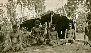
Aboriginal people have lived on Groote Eylandt for thousands of years. Before Europeans arrived, the local Aboriginal people had regular contact with Macassan traders. These traders came from a place called Makassar. You can still see signs of this contact in some place names on the island, like Umbakumba.
The first time Europeans saw Groote Eylandt was in 1623. This happened when a Dutch ship called the Arnhem sailed by. It was led by Willem van Coolsteerdt.
The first European settlement on the island started in 1921. It was a Christian mission set up by the Church Missionary Society at Emerald River. During World War II in 1943, the mission moved to Angurugu. This was because the RAAF needed to use the mission's airstrip. You can still see the ruins of the RAAF base today.
In 1979, the local Aboriginal Town Council took control of the island. Groote Eylandt became Aboriginal freehold title land. This happened after the Aboriginal Land Rights (Northern Territory) Act 1976 was passed.
In 2008, the Australian government made a deal with the local Aboriginal people. The government agreed to lease land on Groote Eylandt for 40 years. In return, the government promised to spend money to improve housing, education, and health in the area.
Island Media
The Eylandt Echo is a newsletter that comes out every two weeks. Its goal is to keep everyone in the community updated. It shares local news, events, and fun activities. GEMCO sponsors the Eylandt Echo as a service to the community.
The people of Groote Eylandt are also working on starting a TV station. It will show different channels and is sponsored by GWN7.
Famous People from Groote Eylandt
- Donald Thomson (1901–1970) was an Australian expert in people and animals.
- David Warren (1925–2010) invented the flight data recorder. He was born on Groote Eylandt.
- Nick Kenny (1982–) is a former rugby league player. He moved to Groote Eylandt.
- Norman Tindale (1900–1993) was an Australian expert in people, old things, insects, and cultures.
- Emily Wurramara is a singer-songwriter who was born on the island.
- Kaye Aldenhoven is a poet who lived and taught on the island.
See also
 In Spanish: Groote Eylandt para niños
 | Laphonza Butler |
 | Daisy Bates |
 | Elizabeth Piper Ensley |


