Sahul Shelf facts for kids
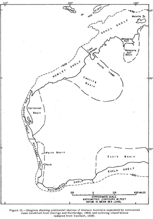
The Sahul Shelf is a very large underwater area that is part of the continental shelf of Australia. It stretches out from the northwest coast of mainland Australia. Think of it as a shallow underwater extension of the land, like a wide, flat underwater plain.
Contents
Where Did the Name Sahul Come From?
The name "Sahul" has a long history. In the 1600s, Dutch maps showed a submerged sandbank between Australia and Timor called "Sahull" or "Sahoel."
Later, in 1803, explorer Matthew Flinders marked a "Great Sahul Shoal" on his map. This was a place where Malays from Makassar would come to fish for trepang, also known as sea cucumber.
The full name "Sahul Shelf" was first used in 1919. It was created by Gustaaf Adolf Frederik Molengraaff, a Dutch expert in geology. He studied the land and rocks of the area, which was then called the Dutch East Indies.
Where is the Sahul Shelf Located?
The Sahul Shelf extends northwest from Australia. It lies mostly under the Timor Sea, reaching towards the island of Timor. It ends where the ocean floor suddenly drops into a very deep area called the Timor Trough.
To the northeast, the Sahul Shelf connects with the Arafura Shelf. This part goes from Australia's northern coast under the Arafura Sea and stretches north towards New Guinea. The Aru Islands are a group of islands that rise up from the Arafura Shelf.
Sometimes, the Sahul Shelf is also considered to include the Rowley Shelf. This area is southwest of Cape Leveque and follows the northern coast of Western Australia all the way to North West Cape.
In 1845, a person named George Windsor Earl suggested that a large underwater bank existed. He called it the "Great Australian Bank." He noticed that animals like kangaroos were found in Australia, New Guinea, and the Aru Islands. This suggested these lands were once connected.
How the Sahul Shelf Changed Over Time
During the Pleistocene ice age, the Earth was much colder. This included the last glacial maximum about 18,000 years ago. At these times, a lot of the Earth's water was frozen in huge ice sheets. This caused sea levels to fall dramatically.
When sea levels dropped, the Sahul Shelf became dry land. Scientists have found evidence of these ancient shorelines. They are now located 100 to 140 metres below the current sea level.
The Arafura Shelf, which connects to the Sahul Shelf, also became dry land. It formed a land bridge that connected Australia, New Guinea, and the Aru Islands. Because of this land bridge, these areas share many types of animals. This includes Marsupial mammals, land birds, and freshwater fish.
A special line called Lydekker's Line runs along the edge of the Sahul Shelf. This line marks where the shelf drops off into the deep waters of the Wallacea area. Wallacea is a unique region with its own animals. It sits in a gap between the Sahul Shelf and the Sunda Shelf, which is part of Southeast Asia's continental shelf.
See also
 In Spanish: Sahul para niños
 | Georgia Louise Harris Brown |
 | Julian Abele |
 | Norma Merrick Sklarek |
 | William Sidney Pittman |


