
Theatrum Orbis Terrarum facts for kids

In 1570 (May 20) Gilles Coppens de Diest at Antwerp published 53 maps created by Abraham Ortelius under the title Theatrum Orbis Terrarum, considered the "first modern atlas". Three Latin editions of this (besides a Dutch, a French and a German edition) appeared before the end of 1572; twenty-five editions came out before Ortelius' death in 1598; and several others were published subsequently, for the atlas continued to be in demand till about 1612. This is the world map from this atlas.
|
|
| Author | Abraham Ortelius |
|---|---|
| Genre | Atlas |
| Publisher | Gilles Coppens de Diest |
|
Publication date
|
1570 |
Theatrum Orbis Terrarum means "Theatre of the Lands of the World." It is known as the very first modern atlas. An atlas is a book filled with maps.
This important book was created by Abraham Ortelius. He was greatly encouraged by Gillis Hooftman. The first version was printed on May 20, 1570, in Antwerp. It had many map sheets and helpful descriptions. These maps were specially made for the book.
The Ortelius atlas is like a summary of all the map-making knowledge from the 1500s. Its release in 1570 is often seen as the start of the Golden Age of Netherlandish cartography. This was a time when map-making in the Netherlands was very popular and advanced.
Contents
What's Inside the First Atlas?
The Theatrum Orbis Terrarum was special because it brought together maps from many different mapmakers. Ortelius himself did not draw most of the maps. Instead, he collected 53 maps from other experts. He always gave credit to the original mapmakers.
Before this atlas, map collections were usually made one by one for specific customers. But Ortelius made all the maps in his atlas look the same. They were all the same size and printed from copper plates. The maps were also organized in a logical way. They were grouped by continent, region, and country.
On the back of each map, Ortelius added helpful descriptions and notes. This was the first time that so much knowledge about the world was gathered into one book. It showed everything people in Western Europe knew about the world at that time.
Who Made the Maps?
In a section called 'Catalogus Auctorum' (List of Authors), Ortelius listed the mapmakers he used. He mentioned 33 mapmakers whose work was in the atlas. He also listed 87 other mapmakers from the 1500s that he knew about. This list grew over time. By 1601, it had 183 names!
Some of the maps in the atlas came from famous works. For example, the world map was based on a map by Giacomo Gastaldi from 1561. The map of the Atlantic coast came from Diego Gutierrez's work in 1562. Eight maps were even based on the famous 1569 world map by Gerardus Mercator.
For the map of Europe, Ortelius used a wall map by Mercator from 1554. The map of Scandinavia was based on a 1539 map by Olaus Magnus. Ortelius's own map of Asia from 1567, which was inspired by Gastaldi, was used for the Asia section. He also used Gastaldi's work for the map of Africa.
Ortelius carefully chose the best maps. He sometimes combined them or split them up. He made sure they all fit the same size pages (about 35 x 50 cm). However, the names of places and their exact locations were not always the same across all maps.
How the Atlas Changed Over Time
After the first book came out, Ortelius kept making changes and adding more maps. He released new versions of the atlas until he died in 1598.
The first edition in 1570 had 70 maps and 87 references to other works. By 1612, the atlas had grown a lot. It had 31 different editions, with 167 maps and 183 references!
One version from 1573, kept at the State Library of New South Wales, has 70 large, two-page maps. Most maps mention the name of the mapmaker Ortelius used. In the introduction, Ortelius thanked Franciscus Hogenberg for engraving almost all the maps.
A special addition in 1573 was the Cambriae Typus by Humphrey Llwyd. This was the first map ever to show only Wales.
The Theatrum Orbis Terrarum is also featured in the Fool's Cap Map of the World. This is a funny map that makes fun of how Europeans understood the world back then.
Later, in the 1630s, the Blaeu family made their own atlas with a similar name: Theatrum orbis terrarum, sive, Atlas Novus.
The Book's Layout

All the different versions of the atlas had a similar structure. They started with a special title page. This page showed five women who represented the five known continents. Europe was shown as a queen.
Next, there was a dedication to Philip II of Spain, who was the King of Spain and the Low Countries. There was also a poem by Adolphus Mekerchus. From 1579 onwards, the books included a picture of Ortelius himself, drawn by Philip Galle.
After that came an introduction written by Ortelius. In the Latin versions, there was also a recommendation from Gerardus Mercator. Then came the 'Catalogus Auctorum' (list of authors) and an 'Index Tabularum' (index of maps).
The main part of the book was the maps, with text on the back of each. Later editions (from 1579 in Latin) also included a list of ancient place names called 'Nomenclator'. There was also a section about Anglesey, an island in Wales, written by Humphrey Llwyd. Finally, the book ended with information about its official permission to be printed and the publisher's details.
Why Was It So Popular?
The Theatrum Orbis Terrarum was a big hit with the middle class. These were people who had money and were very interested in learning and science. They liked the atlas because it was a convenient size. It also brought together so much knowledge in one place.
To reach more people, Ortelius started publishing the atlas in different languages. From late 1572, you could buy it in Dutch, German, and French, not just Latin.
Because it was so popular, Ortelius kept making the atlas bigger and better. In 1573, he added 17 more maps in a section called Additamentum Theatri Orbis Terrarum. This brought the total number of maps to 70. By the time Ortelius died in 1598, there had been 25 editions published in seven different languages.
Image gallery
-
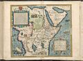
Africa and the Arabian Peninsula
-
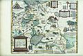
Russia and Tartary
-
China and South East Asia, with West at the top
-
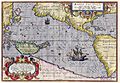
Maris Pacifici including Terra Australis
-
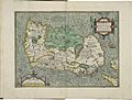
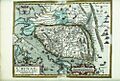
Hibernia


See also
- Maris Pacifici
- Early world maps
- History of cartography
- List of geographers
- Mappa Mundi
- Here be dragons
- Terra incognita
- Golden Age of Netherlandish cartography (also known as the Golden Age of Dutch and Flemish cartography)
