Cambriae Typus facts for kids
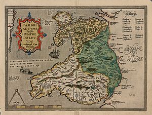
Cambriae Typus means "model image of Wales." It is the very first map ever printed that showed Wales as its own country, separate from the rest of Great Britain. A clever person named Humphrey Llwyd created this map in 1573. It shows Wales reaching all the way to the River Severn. This area includes parts of what is now England.
How the Map Was Made
Humphrey Llwyd (1527–1568) was a Welsh historian, doctor, and politician. Even though he wasn't a professional mapmaker, he started working on Cambriae Typus late in his life. Before he passed away, he sent his handwritten map to Abraham Ortelius. Ortelius was a famous map publisher.
Ortelius printed Llwyd's map in 1573. It was part of an extra section for his big map book called Theatrum Orbis Terrarum. The map was named Cambriae Typus. Llwyd's map of Wales was printed next to another map he made, which showed both Wales and England together. Later, Cambriae Typus was updated and used in other map books, like the Mercator atlas in 1607.
Map Details
The original handwritten map, made on four sheets, is now lost. But you can still find printed copies from Ortelius's book. Even though it's often called a 1573 map, the National Library of Wales thinks it might have been printed in 1574.
The first printed map was about 47.2 by 34.7 centimeters in size. It used a special type of writing called Ortelius typeface. The map's scale was set at about 1:520,000. This means that one unit on the map represented 520,000 units in real life.
What the Map Shows
Cambriae Typus was the first map to show Wales as a separate country. However, the map wasn't very accurate, even for its time. It had several mistakes that other maps from that period didn't have. Some people think the coastline might look wrong because Ortelius made a mistake when copying Llwyd's original. Others believe Llwyd might have based his map on an older, incorrect map.
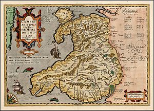
The names of places on the map are written in Latin, English, and Welsh. The back of the map had the same information in German. The map also shows some cool features. In the bottom left corner, there's a divider caliper, which is a tool used for measuring distances. There's also a fancy decorated box called a cartouche. You can see a sailing ship in Cardigan Bay and even a sea monster in the Irish Sea near the coast of Pembrokeshire! The map also has a decorative border around it.
Over time, Llwyd's map was updated five times. One update was a copper etching made by Peter Kaerius and published by Jodocus Hondius in 1603. This version kept the main parts of the map but changed some of the extra pictures. In the 1603 print, the dividers were replaced with a compass. The cartouche was made bigger. The original ship and sea monster were removed and replaced with different ones. A 1612 version of the map had a clearer coastline, based on the original.
The map shows Wales reaching to the River Severn, which is land now part of England. Llwyd made this map to show the culture and history of Wales, not just the political borders of his time.
 | Stephanie Wilson |
 | Charles Bolden |
 | Ronald McNair |
 | Frederick D. Gregory |


