Diego Gutiérrez (cartographer) facts for kids
Diego Gutiérrez was an important Spanish mapmaker and expert in studying the universe. He worked for the Casa de la Contratación, which was a special government office in Spain that controlled trade and exploration. He became a royal mapmaker on October 22, 1554, after his father, who had the same job, passed away. Diego Gutiérrez helped create the Padrón Real, which was the official master map used by all Spanish ships sailing for the king.
Contents
A Master Mapmaker
Diego Gutiérrez was a cosmographer and cartographer. A cosmographer studies the universe and how to map it, including stars and planets. A cartographer is someone who draws maps. His job was to make sure the maps used by Spanish explorers were as accurate as possible. The Padrón Real was like the most important map of its time for Spain. It was constantly updated with new discoveries from voyages around the world.
His Amazing Map of the New World
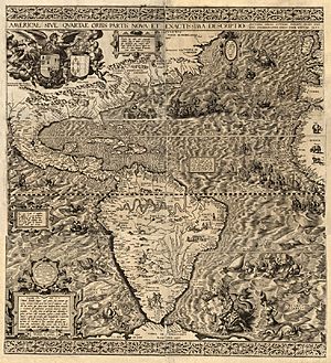
In 1562, Diego Gutiérrez published a very special map. It was called Americae Sive Quartae Orbis Partis Nova Et Exactissima Descriptio. This long name means "A New and Most Accurate Description of America or the Fourth Part of the World." He created this map with a printer named Hieronymus Cock in Antwerp. At that time, Antwerp was part of the Spanish Netherlands.
Why Antwerp?
You might wonder why such an important Spanish map was printed in Antwerp. The reason was simple: the mapmakers in Spain were not skilled enough to print such a detailed and complicated map. The engravers in Antwerp had much better techniques for printing large, intricate documents like Gutiérrez's map.
What the Map Showed
Gutiérrez's map was truly remarkable for its time. It showed many real places, like the huge Amazon River system and Lake Titicaca in South America. But it also included some fun and imaginary things! You could see drawings of parrots, monkeys, and even mythical creatures like mermaids and giant sea monsters. The map also showed Patagonian giants and an erupting volcano in central Mexico.
Naming New Lands
This map was also very important because it was the first to print the name "California" on it. It also showed the first appearance of a word for "Appalachia," using the term "Apalchen" to describe that region. This helped explorers and future mapmakers understand and name these new lands.
See also
 In Spanish: Diego Gutiérrez (cartógrafo) para niños
 | Valerie Thomas |
 | Frederick McKinley Jones |
 | George Edward Alcorn Jr. |
 | Thomas Mensah |


