
Atlas facts for kids
An atlas is a special book or collection of maps. It's like a big book of pictures showing different parts of the world. Atlases are usually printed as books, but you can also find them online or on computers.
Atlases show you many things, like where countries are and their borders. They can also show you mountains, rivers, and oceans. Sometimes, atlases even include facts about people, cultures, or how money is made in different places. They are a great way to learn about our planet!

Contents
History of Atlases
How Atlases Started
The first books that were like atlases didn't have that name. The very first one was put together using the ideas of a geographer named Claudius Ptolemy. He lived around A.D. 150 in a city called Alexandria.
The first printed version of Ptolemy's work came out in Bologna in 1477. It had 27 maps. We don't know for sure if these maps were exact copies of Ptolemy's original drawings. They might have been created by scholars later on, based on his writings.
Atlases in the 1500s
Around 1544, many maps were made, especially in important trading cities like Rome and Venice. Each mapmaker worked on their own. They made maps that were useful for their own needs, so the maps were often different sizes.
Over time, people started putting these maps together into one book. Even though they weren't called "atlases" back then, we now call these collections "Lafreri atlases." This name comes from one of the main map publishers of that time.
Modern Atlases Today
How Atlases Are Made Now
Today, map publishers around the world can share and print maps from other places. This means that the names of places on maps often use the language of the country where that place is. This helps the atlas be useful to more people everywhere.
For example, if you see islands near Russia, their names might have "O." before them. This "O." stands for "ostrov," which means "island" in Russian. This is different from how we usually write "island" in English, but it helps people from different countries understand the map better.
Important Atlases Over Time
Atlases from the 1600s and Earlier
- Piri Reis Map (Made in the Ottoman Empire, 1570-1612)
- Theatrum Orbis Terrarum (From the Netherlands, 1570-1612)
- Dell'Arcano del Mare (Made in England/Italy, 1645-1661)
Atlases from the 1700s
- Cartes générales de toutes les parties du monde (From France, 1658-1676)
- Britannia Depicta (Published in London, 1720)
- Atlas Nouveau (Published in Amsterdam, 1742)
- Cary's New and Correct English Atlas (Published in London, 1787)
Atlases from the 1800s
- Stielers Handatlas (From Germany, 1817-1944)
- Andrees Allgemeiner Handatlas (From Germany, 1881-1939; also known as Times Atlas of the World in the UK, starting 1895)
- Rand McNally Atlas (From the United States, 1881-present)
Atlases from the 1900s
- Times Atlas of the World (From the United Kingdom, 1895-present)
- Atlante Internazionale del Touring Club Italiano (From Italy, 1927-1978)
- Atlas Mira (From Russia, 1937-present)
- Gran Atlas Aguilar (From Spain, 1969/1970)
- Pergamon World Atlas (1962/1968)
- National Geographic Atlas of the World (From the United States, 1963-present)
- Historical Atlas of China (From China)
You can find many old and new atlases online. The DavidRumsey.com website has a large collection of digitized world atlases from the 1700s to the 1900s.
Related pages
Images for kids
-
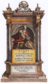
This is the front page of Mercator's atlas from 1595.
-
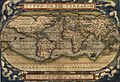
A world map from Theatrum Orbis Terrarum by Abraham Ortelius, made in 1570.
-
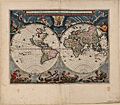
Blaeu's world map, created for his Atlas Maior, published in 1664.
-
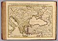
Imperii Orientalis et Circumjacentium Regionum by Guillaume Delisle (1742).


.jpg)

See also
 In Spanish: Atlas (cartografía) para niños
