
World map facts for kids


A world map is a picture or drawing of most or all of the Earth's surface. Because the Earth is a round globe and maps are flat, making a world map is tricky! It's like trying to flatten an orange peel without tearing or stretching it. All flat maps have some kind of distortion, meaning they don't show everything perfectly. This is especially true for world maps. People have invented many different ways to make world maps, trying to make them as accurate and useful as possible.
To create a world map, people needed to know a lot about the Earth. This includes its oceans and continents. For a long time, it was impossible to make an accurate world map. This was because people only knew about a small part of the Earth. Explorers started traveling more during the European Renaissance (a period of great learning). As they explored, our knowledge of the Earth grew quickly. By the mid-1700s, most of the world's coastlines were mapped. By the 1900s, even the inside parts of the continents were known.
World maps usually focus on two main things: political features or physical features.
- Political maps show things like country borders and cities. They highlight where people live and how land is divided.
- Physical maps show natural features. These include mountains, rivers, deserts, and different types of land.
- Some maps, called thematic maps, show specific information. This could be things like how many people live in an area or where volcanoes are.
Contents
How Maps Are Made: Projections
All world maps use something called a map projection. This is a special method to show the round Earth on a flat surface. Imagine shining a light through a globe onto a flat wall. The shadow it makes is a projection!
Every projection changes the Earth's features in some way. It might stretch distances, change shapes, or make directions look wrong. Different map projections try to balance these problems. They aim to be accurate in some ways, even if they distort others.
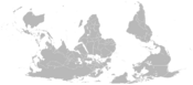
One of the most famous projections is the Mercator Projection. It was first made for sailors to help them navigate ships.
-
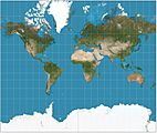
Mercator projection
(This map is great for showing directions, but it makes areas near the poles look much bigger than they are.) -
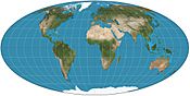
Mollweide projection
(This map shows the correct size of land areas, but it distorts their shapes.) -
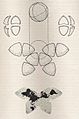
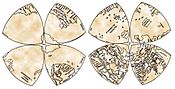
B.J.S. Cahill Butterfly Map, 1909
(This map unfolds like a butterfly, trying to reduce distortion.) -
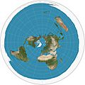
Polar azimuthal equidistant projection
(This map is centered on a pole, showing true distances from that center point.) -
A south-up map
(This map shows the world with the South Pole at the top, which can make you see the world differently!) -
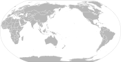
Pacific-centric map
(This map puts the Pacific Ocean in the center. It's often used in countries like Japan and Australia.) -
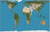
Gall–Peters projection
(This map shows the correct size of countries, but their shapes can look stretched.) -
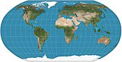
Robinson projection
(This map tries to make a good balance between showing correct shapes and sizes. It was used by National Geographic for many years.)


Maps That Tell a Story: Thematic Maps
A thematic map is a special kind of map that focuses on one or a few specific topics. These maps can show all sorts of information. They might show where different climates are, how many people live in an area, or even where volcanoes are found. They help us understand patterns and information about the world.
-
Clickable world map
(This map shows different climate zones around the world.) -
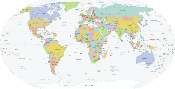
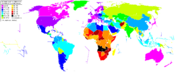
A simple political map of the world
(This map highlights country borders.) -
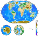
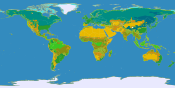
Topographical map of the world
(This map shows the height of land, like mountains and valleys.) -
Map of CO2 emission by country
(This map shows which countries produced the most carbon dioxide between 1950 and 2000.) -
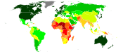
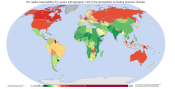
United Nations Human Development Index by country as of 2016
(This map shows how well people live in different countries, based on things like education and health.) -
World map showing life expectancy
(This map shows how long people are expected to live in different parts of the world.) -
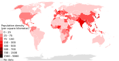
2018 population density
(This map shows how many people live in each square kilometer of land.) -
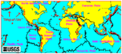
Volcano map
(This map shows where volcanoes are located around the world.) -
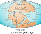
World map showing the continents circa 200 million years ago (Triassic period)
(This map shows how the continents looked a very long time ago, when they were part of two supercontinents.) -
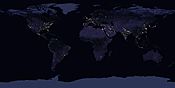
Satellite image of Earth at night
(This amazing image shows the Earth lit up at night, highlighting cities and human activity.)

.svg)


Maps from the Past: Historical Maps
Early world maps are old drawings of the world. They come from ancient times up to the period when modern geography began. These old maps are really interesting! They show us what people knew about places long ago. They also tell us about the ideas and beliefs people had about the world. Often, these ideas were very different from what we know today. Maps are a way that scientists and explorers share their discoveries and pass them on to future generations.
-
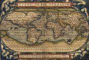
The world, Abraham Ortelius's Typus Orbis Terrarum, first published in 1564
(This was one of the first modern world atlases.) -
Hypothetical reconstruction of the world map of Anaximander (610–546 BC)
(This is how an ancient Greek philosopher might have drawn the world.) -
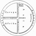
World map according to Posidonius (150–130 BC), drawn in 1628
(This map shows the world as an ancient Greek thinker imagined it.) -
Ideal reconstruction of medieval T-and-O maps
(These maps were popular in the Middle Ages and showed the world divided into three parts.) -
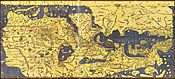
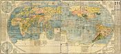
Tabula Rogeriana world map by Muhammad al-Idrisi in 1154
(This famous map was made by an Arab geographer. Notice that north is at the bottom!) -
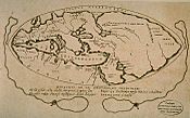
World map in Octant projection (1514), from Leonardo da Vinci's Windsor papers
(Even the famous artist Leonardo da Vinci drew maps!) -
World map by Gerardus Mercator (1569)
(This is the first map to use the famous Mercator projection.) -
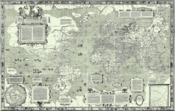
Kunyu Wanguo Quantu (Ming dynasty, 1602)
(This is a Chinese world map from the Ming Dynasty, showing the Americas.) -
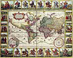
1652 world map by Claes Janszoon Visscher
(A detailed world map from the 17th century.) -
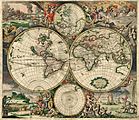
A historical map of the world by Gerard van Schagen, 1689
(Another beautiful map from the late 1600s.)


.jpg)


See also
 In Spanish: Mapamundi para niños
- Wikipedia's clickable world map
- Global Map
- Globe
- International Map of the World
- List of map projections
- List of world map changes
- Mappa mundi
- Maps of the world
- Rhumbline network
- Theorema Egregium
- Time zone
