
Kunyu Wanguo Quantu facts for kids
Quick facts for kids Kunyu Wanguo Quantu |
|||||||||||||||||||||||||||||||||
|---|---|---|---|---|---|---|---|---|---|---|---|---|---|---|---|---|---|---|---|---|---|---|---|---|---|---|---|---|---|---|---|---|---|
| Chinese name | |||||||||||||||||||||||||||||||||
| Traditional Chinese | 坤輿萬國全圖 | ||||||||||||||||||||||||||||||||
| Simplified Chinese | 坤舆万国全图 | ||||||||||||||||||||||||||||||||
| Literal meaning | A Map of the Myriad Countries of the World | ||||||||||||||||||||||||||||||||
|
|||||||||||||||||||||||||||||||||
The Kunyu Wanguo Quantu (meaning "A Map of the Myriad Countries of the World") is a very old and important world map. It was made in China in 1602 during the Ming dynasty. This map was special because it was the first Chinese map to combine what the Chinese knew about the world with what Europeans knew.
It was created by an Italian Catholic missionary named Matteo Ricci, along with Chinese helpers like Zhong Wentao and Li Zhizao. The Wanli Emperor himself asked for this map to be made. The Kunyu Wanguo Quantu helped people in China learn much more about the rest of the world. Later, copies of this map were sent to Korea and Japan, where they also became very important.
Contents
What Does the Map Show?


The 1602 Ricci map is very large, about 5 feet tall and 12 feet wide. It was made using a special printing method called woodcut. The map was carved onto six big pieces of wood, then printed with brownish ink onto six large paper panels. These panels could be joined together, much like a folding screen.
This map was the first in Chinese to show the Americas. It shows both North America and South America, as well as the Pacific Ocean, quite accurately for its time. China is shown connected to Asia, India, and the Middle East. Europe, the Mediterranean Sea, and Africa are also drawn well.
Experts say that while there are some small mistakes, the map shows what people knew about the world through trade and exploration back then. An official from the Chinese Embassy in Washington, D.C., once said that the map was a "momentous first meeting of East and West" and helped boost trade.
Interesting Details on the Map
The map has many pictures and notes that describe different parts of the world.
- For example, it mentions that Africa has the world's highest mountain and longest river.
- The description of North America talks about "humped oxen" (which are bison) and wild horses. It also names Canada and calls Florida the "Land of Flowers."
- Several places in Central and South America are named, such as Guatemala, Yucatan, and Chile.

Matteo Ricci, the mapmaker, wrote a short note about how the Americas were discovered. He explained that long ago, no one knew about North and South America or a supposed southern continent called Magellanica. But about a hundred years before his map, Europeans sailed to these places and found them.
The map also includes other interesting facts:
- It explains how eclipses happen and how to measure the Earth and Moon.
- It proves that the Sun is larger than the Moon.
- It has a table showing how far planets are from Earth.
- It explains why the length of days and nights changes.
- There are also special polar views of the Earth that match the main map.
On the map, Ricci included a personal message. He wrote about how important maps and history are for sharing knowledge with future generations. He signed it on August 17, 1602.
How the Map Was Made

Matteo Ricci (1552–1610) was a Jesuit priest. He was one of the first Western scholars to live in China and became very good at reading and writing Chinese. In 1583, Ricci arrived in China from Macao.
Ricci made his first Chinese world map, called Yudi Shanhai Quantu, in 1584. He had a small Italian map with him and made Chinese versions of it because the local governor, Wang Pan, wanted a map for explorers and scholars.
In 1601, Ricci was the first Jesuit to enter Beijing, the capital of the Ming Dynasty. He brought European maps that were new to the Chinese. In return, the Chinese had maps of the East that were new to Western scholars.
In 1602, the Wanli Emperor asked Ricci to create a new, larger world map. Ricci worked with Zhong Wentao and Li Zhizao to create the Kunyu Wanguo Quantu. This map was special because it combined European and Chinese knowledge, showing the world in a way no map had before. It was the first time the Chinese learned about the existence of America from a map.

Ricci made several versions of Chinese world maps during his time in China:
- A 1584 map called Yudi Shanhai Quantu.
- A 1596 map carved on stone, called Shanhai Yudi Tu.
- A 1600 updated version of the 1596 map.
- The 1602 Kunyu Wanguo Quantu, which was much larger and more detailed.
Many copies of the 1602 map were made, but most are now lost. Only six original copies are known to still exist, and only two are in good condition. These rare copies are found in places like the Vatican Library and the James Ford Bell Library in the United States.
The map became very popular and was copied many times. Ricci himself thought that over 1,000 copies of the 1602 edition were reprinted.
The Map's Journey to Other Countries
.jpg)
Different versions of the map were sent to Korea and Japan.
- The first Korean copy was brought back from Beijing by ambassadors in 1603.
- In Japan, a detailed two-page colored copy, known as Konyo Bankoku Zenzu, was made around 1604. This Japanese copy used Japanese writing (Katakana) for foreign place names.
A famous Korean copy, called Gonyeomangukjeondo, was hand-copied by a painter named Kim Jin-yeo in 1708. This map is very large (about 5.3 meters by 1.7 meters) and is now a National Treasure displayed at Seoul National University Museum. It shows five continents and over 850 place names, along with descriptions of different groups of people and products from each region.
The Bell Library Copy

In 2009, the James Ford Bell Trust bought one of the well-preserved copies of the 1602 Ricci map for one million US dollars. This was one of the most expensive map purchases ever! This copy had been owned by a private collector in Japan for many years.
Ford W. Bell, whose grandfather started the trust, said that opportunities to buy such rare and important maps don't come along very often.
This map was shown for the first time in North America at the Library of Congress in 2010. It was scanned to create a permanent digital image that can be studied online by students and scholars around the world. After that, it moved to its permanent home at the James Ford Bell Library at the University of Minnesota.
Later Chinese Maps
After 1602, Matteo Ricci made four more world maps before he passed away in 1610. Most of these later maps are also lost today. However, copies of the 1602 Kunyu Wanguo Quantu can still be found in places like China, Korea, London, and Vienna.

Other Jesuits also made maps based on Ricci's work. Around 1620, Giulio Aleni created a map called Wanguo Quantu (meaning "Complete map of all the countries"). This map also put China at the center and followed Ricci's style, but it was much smaller.
In 1674, another Jesuit named Ferdinand Verbiest created an improved map called Kunyu Quantu. This map was made for the Kangxi Emperor and was even more detailed. It has eight panels and shows two hemispheres. There are at least 14 or 15 copies of this map known today in various countries.
Why Was This Map Important for Religion?
Matteo Ricci was a Jesuit priest, and his main goal was to teach the Chinese about Roman Catholicism. He believed that by showing the Chinese how much Europeans understood the world, he could also show the greatness of his Christian faith. The words on the map itself show that Ricci used it as a way to explain the power and unity of God, who he believed created and controls everything.
Images for kids
-
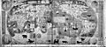
Unknown edition or poor copy of 1602 Ricci map
-
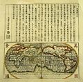
1620s Wanguo Quantu map, by Giulio Aleni, whose Chinese name (艾儒略) appears in the signature in the last column on the left, above the Jesuit IHS symbol.
-
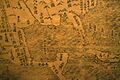
1602 Ricci map - detail of Gulf of Mexico, Florida, Cuba, Yucatan, Mexico
-
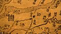
1602 Ricci map - detail from a China panel
-
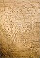
1602 Ricci map - detail of North and Central America
-
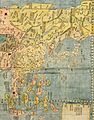
Detail of China and Far East, from the 1604 copy


