
Robinson projection facts for kids
Imagine trying to flatten an orange peel without tearing it! That's a bit like what mapmakers face when they try to show our round Earth on a flat map. It's impossible to do it perfectly. The Robinson Projection is a special kind of map that tries to make this challenge easier. It's a way of drawing the world that looks good and is easy to read, even though it can't be perfectly accurate everywhere.
Contents
What is the Robinson Projection?
The Robinson Projection is a type of map that shows the whole world on a flat surface. It was created by a geographer named Arthur H. Robinson in 1963. He designed it to be a good "compromise" map. This means it tries to balance different things that are important in a map, like getting the shapes of countries right, or showing their true sizes, or making sure distances look correct. Since you can't get all of these perfect on a flat map, the Robinson Projection tries to find a good middle ground.
Why Do We Need Different Maps?
Our Earth is a sphere, like a ball. When you try to unroll a ball onto a flat piece of paper, something has to stretch or shrink. This is why different map projections exist. Some maps are good for showing true sizes, but they might distort shapes. Others might show shapes correctly, but the sizes will be off. The Robinson Projection was made to look pleasing to the eye and be useful for general purposes, like in atlases or textbooks.
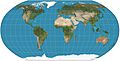
How the Robinson Map Looks
On a Robinson map, the lines of latitude (the lines that go around the Earth horizontally, like the equator) are straight and parallel. But the lines of longitude (the lines that go up and down, from pole to pole) are curved. They get more curved as you move away from the center of the map.
A unique feature of the Robinson map is how it shows the North and South Poles. Instead of showing them as single points, it shows them as long lines. This helps to make the high-altitude areas, like the Arctic and Antarctic, look more accurate in terms of their land and water proportions. It avoids making them look too stretched out or too squished, which can happen on other types of maps.
The Robinson Projection is often used because it looks balanced. It doesn't make any one area look extremely distorted, even though it's not perfectly accurate in every way. It's a popular choice for world maps where a good visual representation is more important than perfect measurements.
Images for kids
-
Robinson projection of the world

See also
 In Spanish: Proyección de Robinson para niños
