
Early world maps facts for kids
The earliest known maps of the world are very old, from around 600 to 500 years before BC. These first maps showed the world in a very simple way. Over time, smart Greek thinkers like Eratosthenes and Posidonius helped us understand the Earth better. Their ideas led to Ptolemy's world map in the 2nd century AD. This map was used as the main guide for mapmakers for a very long time, throughout the Middle Ages.
After Ptolemy, mapmakers learned more about how big the Earth really is. During the Age of Discovery, from the 15th to the 18th centuries, people explored new lands. This helped make world maps much more accurate. In the 19th and early 20th centuries, Western mapmakers explored places like Antarctica, Australia, and the inside of Africa. This filled in many missing parts of the world map.
Contents
Early World Maps
Maps have been around for thousands of years! The very first ones were quite simple. They helped people understand their local area. Over time, maps grew to show larger parts of the world.
Ancient Maps
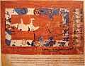
One of the oldest known world maps is the Babylonian Map of the World. It was made around 600 BC on a clay tablet. This map showed the Earth as flat. It had Babylon in the center.
Later, Greek thinkers changed how people saw the world. Eratosthenes (around 276–195 BC) was one of the first to figure out the Earth was round. He even made a good guess at its size! Ptolemy (around 100–170 AD) then created a famous world map. His map used lines of latitude and longitude, much like maps today. It was the most detailed map for over a thousand years.
Maps of the Middle Ages
During the Middle Ages, maps changed a lot. Some maps, like the Tabula Rogeriana (1154) by al-Idrisi, were very detailed for their time. They showed parts of Europe, Asia, and Africa. Other maps, like the Hereford Mappa Mundi (around 1285), were more like artworks. They showed the world based on religious beliefs. Jerusalem was often placed at the center.
The Age of Discovery and Beyond
The 15th and 16th centuries were a time of great exploration. Sailors like Christopher Columbus and Ferdinand Magellan traveled across oceans. This meant mapmakers had to update their maps with new lands.
- The Cantino planisphere (1502) was one of the first maps to show the new discoveries in the Americas.
- The Piri Reis map (1513) was drawn by an Ottoman admiral. It showed parts of the Americas and Africa.
- Gerardus Mercator created his famous Mercator 1569 world map. This map projection made it easier for sailors to navigate. It showed lines of longitude as parallel, which was very helpful for plotting courses.
- Theatrum Orbis Terrarum (1570) by Abraham Ortelius was the first true modern atlas. It was a collection of maps bound together.
As explorers found more of the world, maps became more and more accurate. By the 19th and 20th centuries, almost all parts of the world were mapped. This included the icy lands of Antarctica and the vast interiors of Africa and Australia. Today, we have incredibly detailed digital maps that show every corner of our planet.
Images for kids
-
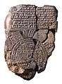
Imago Mundi Babylonian map, the oldest known world map, 6th century BCE Babylonia. Now in the British Museum.
-
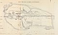
1883 reconstruction of Eratosthenes' map
-
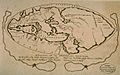
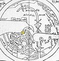
A 1628 reconstruction of Posidonius ideas about the positions of continents (many details couldn't have been known by Posidonius)
-
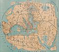
An 1898 reconstruction of Pomponius Mela's view of the World.
-
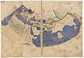
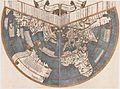
The oldest surviving Ptolemaic world map, redrawn according to his 1st projection by monks at Constantinople under Maximus Planudes around 1300
-
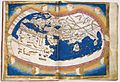
Nicolaus Germanus's 1467 Latin world map according to Ptolemy's 2nd projection, the first known to the west
-
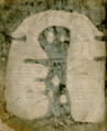
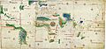
World map by Cosmas Indicopleustes
-
T and O map from a 12th-century copy of Etymologiae
-
Albi Mappa Mundi
-
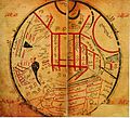
World map by Ibn Hawqal (south at top)
-
The Anglo-Saxon 'Cotton' world map (c. 1040). Britain and Ireland are bottom left.
-
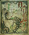
World map from the Saint-Sever Beatus
-
al-Kashgari's Diwanu Lughat at-Turk.
-
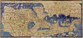
Original Tabula Rogeriana (1154) with south up.
-
The Ebstorf Map, c. 1235.
-
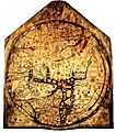
The Hereford Mappa Mundi, c. 1300
-
Pietro Vesconte's world map, 1321
-
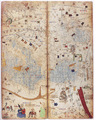
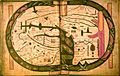
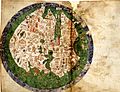
Two leaves of The Catalan world atlas
-
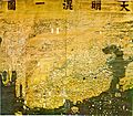
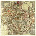
Da Ming Hunyi Tu map
-
Ryūkoku copy of the Gangnido world map (c. 1479–1485)
-
De Virga world map (1411–1415)
-
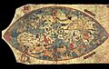
Bianco world map (1436)
-
Borgia map (early 15th century)
-
Genoese map of 1457, Biblioteca Nazionale at Florence
-
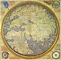
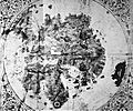
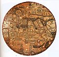
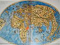
Fra Mauro map (1459)
-
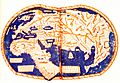
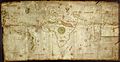
Martellus world map (1490)
-
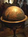
Behaim's Erdapfel
-
Modern recreation of the gores of the Erdapfel
-
Map of Juan de la Cosa, shown rotated right (in the original manuscript north points left), 1500
-
Cantino planisphere, 1502, Biblioteca Estense, Modena
-
Caverio Map (c. 1505), Bibliothèque Nationale de France, Paris
-
Ruysch's 1507 map of the world
-
Waldseemüller map with joint sheets, 1507
-
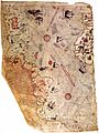
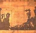
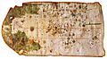
Fragment of the Piri Reis map by Piri Reis in 1513
-
Map of Pietro Coppo, Venice, 1520
-
World Map by Diogo Ribeiro, "Propaganda map" (1529), Biblioteca Apostolica Vaticana
-
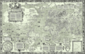
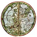
Mercator Nova et Aucta Orbis Terrae Descriptio, 1569. High res image.
-
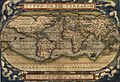
Ortelius's map Theatrum Orbis Terrarum (1570)
-
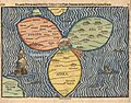
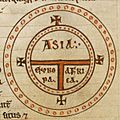
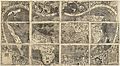
Die ganze Welt in einem Kleberblat (The entire World in a Cloverleaf). Jerusalem is in the centre of the map surrounded by the three continents.
-
Kunyu Wanguo Quantu (1602), Japanese copy
-
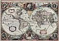
Hendrik Hondius, Nova Totius Terrarum Orbis Geographica ac Hydrographica Tabula, 1630
-
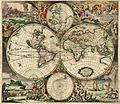
Nicolaes Visscher, Orbis Terrarum Nova et Accuratissima Tabula, 1658
-
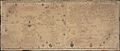
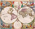
Van Schagen's map of the world, 1689
-
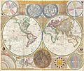
World map by Samuel Dunn, 1794


.jpg)


.jpg)
_balanced.jpg)


See also
 In Spanish: Mapamundis antiguos para niños
