
Babylonian Map of the World facts for kids
Quick facts for kids Babylonian Map of the World |
|
|---|---|

Obverse
|
|
| Material | Clay |
| Size | Height: 12.2 cm (4.8 in) Width: 8.2 cm (3.2 in) |
| Writing | cuneiform |
| Created | after 9th century BC |
| Period/culture | Neo-Babylonian / early Achaemenid period |
| Place | Sippar |
| Present location | British Museum, (BM 92687) |
The Babylonian Map of the World is an ancient clay tablet from Babylonia. It shows a map of the world and has two messages written in the Akkadian language. This map is thought to be from around the 8th or 7th century BC. It is the oldest known map of the world from that time.
The map shows the Euphrates River flowing from top to bottom. The city of Babylon is in the middle of the map, on the Euphrates. Other cities like Susa and Urartu are also shown. The land is surrounded by a circular "bitter river," which means the ocean. Beyond this ocean, there are seven or eight triangular areas. These might be faraway lands or mountains.
This amazing tablet was found by Hormuzd Rassam in Sippar, near the Euphrates River. It was bought by the British Museum in 1882. Scientists first translated the text on the map in 1889. In 1995, a new piece of the tablet was found.
Contents
What the Tablet Shows
The tablet has three main parts. There is the world map itself. Then, there is text written above the map. Finally, there is more text on the back side. It's not totally clear if all three parts were meant to be read together.
The Map Itself

The map is round, with two circles marking its edge. These circles represent a body of water called the "bitter river," or the salt sea. Inside the map, cuneiform writing names different places. Some regions outside the main circle are also named.
Babylon is marked just north of the center. Lines at the bottom seem to show southern marshlands. A curved line from the north-northeast might be the Zagros Mountains.

There are seven small circles inside the main map. These probably show seven different cities. Outside the water circle, there are seven or eight triangular shapes. These are called "regions" (nagu). We still have descriptions for five of these regions.
Here are some of the places and features shown on the map:
- The "Mountain"
- The "City"
- Urartu
- Assyria
- Der (a city)
- Swamp
- Susa (capital of Elam)
- Canal or "outflow"
- Bit Yakin (a region)
- Habban (a Kassite land and city)
- Babylon, split by the Euphrates River
- The Ocean (salt water)
- Outer "regions" (nagu) like the "Great Wall," where the Sun is not seen.
Texts on the Tablet
Front Side Text
The text above the map has 11 lines. It seems to tell a story about how the world was created by Marduk. Marduk was the main god of Babylon. He separated the first ocean, creating land and sea. The text mentions mythical creatures like the Anzu-bird and scorpion-man. It also lists many animals that Marduk created on the land. These animals, like mountain goats, lions, and ostriches, were usually found in faraway lands.
The last two lines of this text mention three famous heroes: Utnapishtim (a hero from a great flood story), Sargon of Akkad (a powerful ancient ruler), and Nur-[D]agan.
Back Side Text
The text on the back of the tablet has 29 lines. It describes at least eight of the "regions" (nagu) that are outside the main map. Each region is introduced by saying, "To the n-th region, where you travel 7 leagues." A "league" was an old way to measure distance. This distance might mean the width of the ocean.
We don't have full descriptions for all regions because some parts are damaged.
- The third region might be a dry desert where even birds cannot fly safely.
- The fourth region mentions objects that are very large.
- The seventh region talks about fast-running cattle with horns.
- The eighth region might describe a special gate in the east where the Sun rises each morning.
The text ends by saying that the map shows "the Four Quadrants of the entire [world?]." It also says that these regions go on forever, so "no one can compre[hend]" them.
The last two lines give the name of the scribe, or writer, who copied the tablet. He copied it from an older version.
Later Ideas
Some historians, like Carlo Zaccagnini, believe that the design of this Babylonian map might have influenced later maps. For example, it might have inspired the "T and O maps" that were common in Europe during the Middle Ages.
See also
Images for kids
-
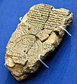
Map of the World from Sippar, Iraq. 6th century BCE. British Museum
-
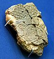
Map of the World from Sippar, Iraq, 6th century BCE. British Museum
-
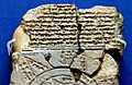
Map of the World from Sippar, Iraq, 6th century BCE. The British Museum


