
Catalan Atlas facts for kids

.jpg)
The Catalan Atlas (also known as Atles català) is a very old world map made in 1375. Many people call it the most important map from the Middle Ages. It was created in the Catalan language and is seen as the best map-making of its time.
This special map was made by the Majorcan cartographic school. It was probably created by Cresques Abraham, a Jewish artist who was very good at making maps and compasses. By 1380, the Catalan Atlas was already in the royal library of France. It is still kept safe today at the National Library of France (the Bibliothèque nationale de France).
The Catalan Atlas was originally made from six large pieces of vellum (a type of treated animal skin). Each piece was about 64.5 by 50 centimeters. They were painted with many bright colors, including gold and silver. Later, these pieces were attached to wooden panels and bound with leather. The map has been repaired several times, most recently in 1991.
Contents
What the Catalan Atlas Shows
{{Location map+ |Eurasia | width=300 | float = right | border = | nodiv = 1 | mini = 1 | relief = yes | places =
| caption=
}
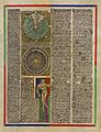
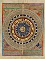
The first two pages of the Atlas are not maps. They contain texts about the universe, stars, and how they might affect people. These texts also have cool pictures. They explain that the Earth is round and describe the known world at the time. Sailors could also find useful information about tides and how to tell time at night.
The other four pages form the actual map. Jerusalem is placed near the center of the map. Two pages show the eastern parts of the world, and the other two show Europe, North Africa, and West Africa. The entire map is about 1.3 square meters in size.
The map shows many cities. Christian cities have a cross symbol, while other cities have a dome. Each city's ruler or country is shown with a flag. Blue wavy lines represent oceans. Important ports have their names written in red, and other places are in black. The pictures and most of the text are drawn towards the edges of the map. This suggests the map was meant to be laid flat, and people would walk around it to read it.
The eastern part of the Catalan Atlas mixes religious stories with travel tales from the time. It includes information from famous travelers like Marco Polo and Sir John Mandeville. You can find many cities from India and China on the map. The notes on the map describe customs that Marco Polo wrote about. They also list local resources, whether real or believed to be real.
The western part of the map looks like other sea charts from that time. But it's special because it has the first compass rose ever shown on such a map. A compass rose helps sailors find directions.
Mali Empire and Mansa Musa

The map shows the Mali Empire and its great wealth under the rule of Mansa Musa. The text next to his picture says:
This black Lord is called Musse Melly and is the sovereign of the land of the black people of Gineva (Ghana). This king is the richest and noblest of all these lands due to the abundance of gold that is extracted from his lands.
This tells us how rich Mansa Musa was because of all the gold from his lands.
India on the Map
_and_King_of_Vijayanagar_(bottom)_in_the_Catalan_Atlas_of_1375.jpg)
The western part of India is clearly drawn, and many place names are correct. In the north, you can see the Sultan of Delhi (Rey de delli), who ruled the Delhi Sultanate. His flag is shown on many cities (![]() ). The map says about him:
). The map says about him:
Here is a great sultan, powerful and very rich: the sultan has seven hundred elephants and a hundred thousand horsemen under his command. He also has countless foot soldiers. In this part of the land there is a lot of gold and precious stones.
In the middle of India, the map shows the old capital of Diogil (Devagiri ![]() ). A unique flag (
). A unique flag (![]() ) flies over Diogil. However, cities along the coast are under the black flag of the Delhi Sultanate (
) flies over Diogil. However, cities along the coast are under the black flag of the Delhi Sultanate (![]() ).
).
A trading ship on the map has the flag of the Ilkhanate (![]() ). Its description says:
). Its description says:
Let it be known that these ships are named nichi, and measure sixty cubits in depth and thirty-four cubits in length; there are few with less than four masts and some even have ten. The sails are made of reed and palm leafs.
This tells us about the large ships used for trade back then.
To the south of India, at the very tip, is the "King of Colombo" with a Christian flag (![]() ). He was thought to be Christian because of the early Saint Thomas Christians in that area. The map says:
). He was thought to be Christian because of the early Saint Thomas Christians in that area. The map says:
Here rules the king of Colombo, a Christian.
The Il-Khanate Empire
.jpg)
The Mongol ruler of the Il-Khanate empire is shown in the area of Persia. He is called "Rey del tauris" after his capital city, Tabriz. The Ilkhanate flag (![]() ) is also shown.
) is also shown.
The text near this area talks about the city of Babylon:
Here there was the Great Babylonia, where Nabuconodosor resided, and that is called Baldaca today. Let it be known that many spices, as well as other noble products, come to this city from the Indies and they are distributed by Siria, in particular at the city of Damascus.
This shows how important this city was for trade.
.jpg)
Above the ruler, there is a city inside a sphere. The text mentions the Persian city of Shiraz and Ptolemy, a famous ancient scholar:
This city is named Siras, and in antiquity, it was named the City of Grace because it was there where astronomy was invented by the great wise man Ptolemy.
Two ships with Ilkhanate flags are shown in the Indian Ocean. They are sailing to and from the coast of India, where the flags of the Delhi Sultanate are seen. One ship's label says:
Know that these ships are called junks (inchi) and have sixty-cubit hulls with thirty-four cubits of freeboard. They have on top of this between four and ten masts, and their sails are of canes and palm.
This describes the large trading ships called "junks" that were used in Asia.
The Golden Horde
.jpg)
The Mongol group known as the Golden Horde is shown correctly north of the Caspian sea. The ruler, Jani Beg, is identified as "Jambech senyor de Sarra". The flag of the Golden Horde (![]() ) also appears. The text on the right says:
) also appears. The text on the right says:
Here resides the emperor of this northern region whose empire starts in the province of Bulgaria and ends at the city of Organcio. The sovereign is named Jambech, Lord of the Sarra.
.png)
The flag of the Golden Horde in the Atlas looks a lot like the special symbols (![]() ) found on their coins. These symbols were used until Jani Beg's time.
) found on their coins. These symbols were used until Jani Beg's time.
The text on the left side of this section describes a desert journey:
Let it be known that those that wish to cross this desert stop and rest during a week in a city named Lop. Here, expeditions and their animals relax/enjoy themselves. After that, they procure what is needed for the next seven months of the journey, because in the desert one travels an entire day and night before reaching potable water; however, every day and a half, they can find plenty of it, enough for fifty or a hundred people or even more. And if it happens that a rider, tired by the journey, falls sleep or for any other reason he separates from his companions, he will often hear the voices of devils, similar to the voices of his companions, often calling him by his own name. In this way, the devils take him through the desert to a fro such that the traveler cannot find his companions. A thousand stories are known about this desert.
This shows the dangers and challenges of traveling through deserts in those times.
Anatolia and Other Regions
.jpg)
The map also shows the Anatolian Beyliks, which were Turkish kingdoms in Anatolia (modern-day Turkey). This region is called Turqhia on the map. The text next to a seated ruler says: Asia Minor also called Turkey, where there are many cities and castles. Many Turkish kingdoms appear with different flags.
The map also shows the Christian kingdom of Cilician Armenia. It is heavily protected by green walls, and its ports and flags (![]() ,
, ![]() ) are clearly visible.
) are clearly visible.
Gog and Magog

The land of "Gog i Magog" (Gog and Magog) is shown in the top right corner of the map. Its king is riding a horse, followed by a parade. Next to it is Alexander's Gate, which shows Alexander the Great, the Antichrist, and trumpeters.
Chagatai Khanate
.jpg)
The map shows Khan Kebek, the Mongol ruler of the Chagatai Khanate. The text says:
Here reigns the King Chabech (Kebek), lord of the Medeja [Media] Empire. He resides at Emalech (Almaliq).
His cities are shown with the Chagatai flag (![]() ).
).
Cathay (China)

.jpg)
_according_to_the_Catalan_Atlas_(1375).jpg)
The cities of Cathay, which was the Empire of the Great Khan (Yuan China) at that time, are shown with a flag that has three red crescent moons (![]() ). This flag appears on all the cities in eastern Asia on the Catalan Atlas.
). This flag appears on all the cities in eastern Asia on the Catalan Atlas.
Kubilai Khan is shown sitting on his throne, wearing a green coat. The text says about him:
The most powerful prince of the Tartars is named Holubeim [Kubilay Khan], that means Great Khan. This emperor is richer than any other emperor in the world. This emperor is protected by twelve thousand horsemen with their four captains that stay at the court three months of the year.
This describes the great power and wealth of the Mongol emperor.
The Antichrist
.jpg)
The Antichrist is shown beyond the Great Wall of China, near the land of Gog and Magog. The label says:
Antichrist. He will be raised in Goraym of Galilea, and at the age of thirty he will start to preach in Jerusalem; contrary to the truth, he will proclaim that he is Christ, the living son of God. It is said that he will rebuild the Temple.
In the top corner, Alexander the Great ("Allexandri") is shown fighting the devil.
Beyond these lands is the "Mare Oceanis" (the Ocean), but there is no mention of Japan.
Images for kids
-
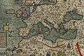
Modern copy of western half
-
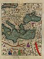
A modern reproduction of the Catalan Atlas depicting the eastern Mediterranean region.
-
Reproduction of the first leaf
-
Reproduction of the second leaf

.jpg)
.jpg)
.jpg)
See also
 In Spanish: Atlas Catalán para niños
- Rhumbline network
- Early world maps
