
Abraham Cresques facts for kids
Quick facts for kids
Abraham Cresques
|
|
|---|---|

A part of the Catalan Atlas by Cresques Abraham and his son Jehuda Cresques
|
|
| Born | 1325 |
| Died | 1387 |
| Other names | Eliça, son of Rabbi Abraham |
| Occupation | cartographer |
| Known for | Catalan Atlas |
Abraham Cresques (born around 1325, died 1387) was a famous mapmaker from the 14th century. He was a Jewish cartographer from Palma, an island called Majorca, which was part of the Crown of Aragon back then.
Abraham Cresques worked with his son, Jehuda Cresques. Together, they created a very well-known map called the Catalan Atlas in 1375.
Contents
Who Was Abraham Cresques?
Abraham Cresques was a Jewish man from Majorca. He was not only a master map-maker but also built clocks, compasses, and other tools for sailors. He was a very important member of the Majorcan cartographic school, a group of skilled mapmakers from Majorca.
His full name was actually Eliça, son of Rabbi Abraham. He was known as Cresques of Abraham. His son, Jehuda Cresques, also became a famous mapmaker.
The Amazing Catalan Atlas

In 1375, Prince John of Aragon (who later became King John I of Aragon) asked Cresques and his son Jehuda to create a special set of maps. These maps needed to show more than just the usual sea routes. They had to cover lands "from the Strait of Gibraltar leading to the West" and also the East.
For this big project, Cresques and Jehuda were paid a good amount of money. Prince John wanted to give this amazing map as a gift to his cousin Charles, who would later become King Charles VI of France.
In that same year, 1375, Cresques and Jehuda drew the six large maps that make up the Catalan Atlas. They worked on it right in their home in the Jewish area of Palma.
Other Maps by Cresques' Workshop
The Catalan Atlas is the only map we are sure Abraham Cresques made. However, experts believe that five other old maps might have been made by Cresques, Jehuda, or someone else from their workshop. These maps do not have signatures or dates, but they are thought to be from between 1375 and 1400.
These other maps include:
- The Catalan Atlas, made around 1375. It has 6 panels and shows the world from the Atlantic Ocean all the way to China. You can find it in the Bibliothèque Nationale de France in Paris, France.
- The Venice chart, made around 1375-1400. This is a portolan chart (a type of sea map) that is missing the northern part of Europe. It is kept at the Biblioteca Marciana in Venice, Italy.
- The Florence chart, made around 1375-1400. This is another portolan chart, but it only shows the western part of the Mediterranean Sea. It is at the Biblioteca Nazionale Centrale in Florence, Italy.
- The Naples chart, made around 1375-1400. This is a regular portolan chart found at the Biblioteca Nazionale Vittorio Emanuele III in Naples, Italy.
- The Istanbul map, made around 1375-1400. This is a small piece of a larger world map (a mappa mundi). It is at the Topkapi Palace in Istanbul, Turkey.
- The Paris chart, made around 1400. This is a portolan chart kept at the Bibliotheque Nationale de France in Paris, France.
Some experts think the Naples and Paris charts look more detailed than the others. The Paris chart, in particular, seems very similar to the Catalan Atlas. However, it is not completely certain that all these maps came from the Cresques workshop.
Cresques also created a special Bible with pictures and a Hebrew-Catalan dictionary. It is known as the Farhi Bible.
Images for kids
-
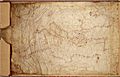
"Venice chart" (It.IV,1912),
Biblioteca Marciana, Venice. -
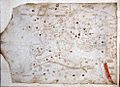
"Naples chart" (XII.D102),
Biblioteca Nazionale Vittorio Emanuele III, Naples. -
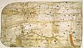
"Paris chart" (AA751),
Bibliotheque Nationale de France, Paris. -
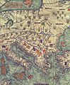
Abraham and Jehuda Cresques Catalan Atlas. Eastern Europe view from the south (detail)
-
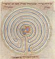
Map of Jericho in the Farhi Bible
.jpg)
.jpg)
.jpg)


See also
 In Spanish: Cresques Abraham para niños
- Catalan Atlas
- Majorcan cartographic school
- Compass rose
- Rhumbline network
