Jericho facts for kids
Quick facts for kids
Jericho
|
||
|---|---|---|
|
Palestinian city
|
||
| Arabic transcription(s) | ||
| • DIN | Arīḥā | |
| Hebrew transcription(s) | ||
| • DIN | Yərīḥō | |
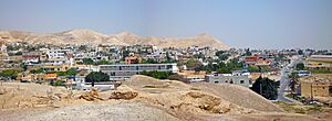
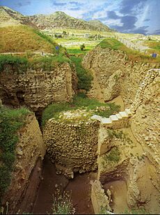
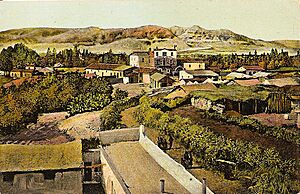
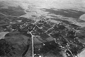
View of Jericho from Tell es-Sultan
|
||
|
||
| State | State of Palestine | |
| Governorate | Jericho | |
| Founded | 9600 BCE | |
| Government | ||
| • Type | City (from 1994) | |
| Area | ||
| • Total | 58,701 dunams (58.701 km2 or 22.665 sq mi) | |
| Elevation | −258 m (−846.5 ft) | |
| Population
(2017)
|
||
| • Total | 20,907 | |
Jericho (pronounced JERR-ik-oh) is a city in Palestine, located in the West Bank. It is the main city of the Jericho Governorate. Jericho is in the Jordan Valley, with the Jordan River to its east and Jerusalem to its west. In 2017, about 20,907 people lived there.
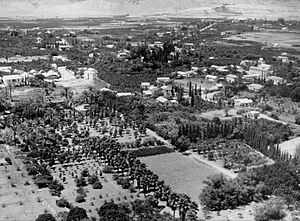
Jericho is one of the oldest cities in the world where people have lived without stopping. It also has the oldest known defensive wall. Experts who study old sites (called archaeologists) have found more than 20 layers of past settlements in Jericho. The very first one dates back 11,000 years, almost to the start of the Holocene period. Many natural springs in and around the city have attracted people to live there for thousands of years. The Bible calls Jericho the "city of palm trees."
In 2023, the ancient site in the city center, called Tell es-Sultan / Old Jericho, was added to UNESCO's World Heritage Site list. It was described as the "oldest fortified city in the world."
Contents
- What Does the Name Jericho Mean?
- Exploring Jericho's Past: History and Archaeology
- The Stone Age: Life at Tell es-Sultan
- The Bronze Age: A Time of Walls and Kings
- Iron Age: Rebuilding and Decline
- Persian and Early Hellenistic Periods
- Hasmonean and Herodian Periods: A Garden City
- Roman Province: Decline and Forts
- Byzantine Period: Christian Growth
- Early Muslim Period: A Fragrant City Again
- Crusader Period: Sugar Production
- Ottoman Period: A Quiet Village
- British Mandate Period
- Jordanian Period
- 1967 and Beyond
- Jericho's Location and Environment
- Who Lives in Jericho? Demographics
- Jericho's Economy and Jobs
- Visiting Jericho: Tourism
- Schools and Religious Places
- Sports in Jericho
- Jericho's Sister Cities
- Notable People from Jericho
- See also
What Does the Name Jericho Mean?
The name Jericho in Modern Hebrew, Yeriẖo, probably comes from the Canaanite word rēḥ, which means "fragrant." Some people think it comes from the Canaanite word Yaraḥ (meaning "moon") or the name of the moon god Yarikh. Jericho was an early center for worshipping this god.
Jericho's Arabic name, Arīḥā, also means "fragrant" and comes from the Canaanite word Reaẖ.
Exploring Jericho's Past: History and Archaeology
Many archaeologists have studied Jericho over the years. The first digs were done by Charles Warren in 1868. Later, Ernst Sellin and Carl Watzinger worked there from 1907 to 1911. John Garstang excavated between 1930 and 1936.
A famous archaeologist named Kathleen Kenyon led big investigations using modern methods from 1952 to 1958. More recently, Lorenzo Nigro and Nicolò Marchetti dug there from 1997 to 2000. Since 2009, Italian and Palestinian teams have continued to explore the site. They have found important things like Tower A1 from the Middle Bronze Age and Palace G from the Early Bronze III period.
The Stone Age: Life at Tell es-Sultan
The very first settlement found was at Tell es-Sultan (or Sultan's Hill), a few kilometers from the modern city. In both Arabic and Hebrew, tell means "mound." This is because old settlements built up layers over time, creating a hill. Jericho is a key site for understanding the Pre-Pottery Neolithic A (PPNA) and Pre-Pottery Neolithic B (PPNB) periods.
Early Hunter-Gatherers: The Natufians (Around 10,000 BCE)
Even before farming began, people were building structures at Jericho. The Natufian culture started building things there before 9000 BCE. This was the beginning of the Holocene period in Earth's history.
Jericho shows signs of people living there as far back as 10,000 BCE. During a cold and dry time called the Younger Dryas, it was hard to live in one place permanently. However, the Ein es-Sultan spring at Jericho was a popular camping spot for Natufian hunter-gatherers. They left behind small, crescent-shaped stone tools. Around 9600 BCE, the cold and dry period ended. This allowed Natufian groups to stay longer, eventually leading to year-round living and permanent settlements.
The Pre-Pottery Neolithic Period (Around 9500–6500 BCE)
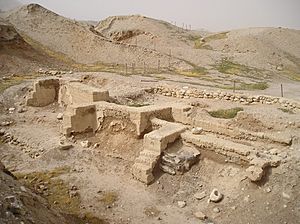
The Pre-Pottery Neolithic period in Jericho is split into two parts: Pre-Pottery Neolithic A and Pre-Pottery Neolithic B.
Pre-Pottery Neolithic A (PPNA)
The first permanent settlement at Jericho grew near the Ein es-Sultan spring between 9,500 and 9000 BCE. As the world got warmer, a new way of life appeared. People started farming and living in one place. Archaeologists call this the "Pre-Pottery Neolithic A" (PPNA) period. People in this culture did not use pottery, but they had:
- Small round houses.
- Burials of the dead under the floors of buildings.
- Hunting wild animals for food.
- Growing wild or farmed grains.
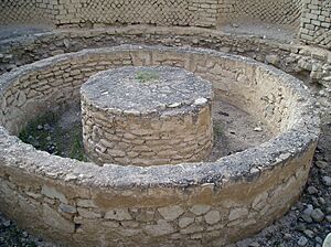
In Jericho, the round houses were made of clay and straw bricks that dried in the sun. They were held together with mud. Each house was about 5 meters (16 feet) wide and had a roof made of mud-covered branches. Fireplaces were both inside and outside the homes.
The PPNA settlement was a large area of about 40,000 square meters (10 acres). It was surrounded by a huge stone wall, over 3.6 meters (12 feet) high and 1.8 meters (6 feet) wide at the bottom. Inside the wall was a stone tower, over 8.5 meters (28 feet) high. This tower had an inner staircase with 22 stone steps. It was placed in the middle of the west side of the tell. This tower and even older ones found in Syria are the oldest towers ever discovered.
The wall might have protected the city from floods, and the tower may have been used for special ceremonies. The wall and tower were built around 8000 BCE. Carbon dating shows the tower was built around 8300 BCE and used until about 7800 BCE. Building the wall and tower would have taken 100 men more than 100 days. This suggests that people had some kind of social organization. The town had round mud-brick houses, but no planned streets. People in the PPNA period grew emmer wheat, barley, and pulses, and they hunted wild animals.
Pre-Pottery Neolithic B (PPNB)
The Pre-Pottery Neolithic B (PPNB) period lasted for about 1,400 years, from 7220 to 5850 BCE. During this time, people:
- Grew a wider variety of plants.
- May have started raising sheep.
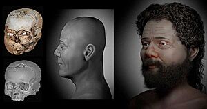
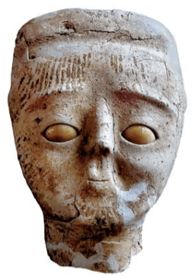
- Had a special practice of keeping human skulls. They would cover the skulls with plaster to rebuild the faces, sometimes using shells for eyes. These might have been early forms of portraits.

After a few centuries, the first settlement was left empty. Then, the PPNB settlement was built on the old tell. This second settlement, started in 6800 BCE, might have been built by new people who joined with the original inhabitants.
The buildings were rectangular and made of mudbricks on stone foundations. The mudbricks were loaf-shaped with deep thumb prints to help them stick together. Rooms often surrounded a central courtyard. There was usually one large room with inner divisions, and smaller rooms likely used for storage. The rooms had red or pink floors made of lime. Some floors still show marks from mats made of reeds. The courtyards had clay floors.
Archaeologists also found tools like arrowheads, sickle-blades, and scrapers. They found grinding stones, hammerstones, and axes made of greenstone. Other items included bowls carved from soft limestone, stone spindle whorls, and small statues of people and animals made of plaster and clay. They also found shell and malachite beads.
The Bronze Age: A Time of Walls and Kings

People continued to live in Jericho from 4500 BCE onwards.
Early Bronze Age Settlements
During the Early Bronze IIIA period (around 2700–2500/2450 BCE), Jericho became its largest. In the Early Bronze IIIB period (around 2500/2450–2350 BCE), there was a Palace G on Spring Hill and city walls.
Middle Bronze Age: A Prosperous City
Jericho was continuously lived in during the Middle Bronze Age. It was destroyed in the Late Bronze Age and stopped being a major city. The city had strong defensive walls with rectangular towers. It also had a large cemetery with deep tombs and underground burial rooms. The fancy items found in some of these tombs might show that local kings were emerging.
During the Middle Bronze Age, Jericho was an important city in the Canaan region. It reached its biggest size during the Bronze Age between 1700 and 1550 BCE. This growth was part of a larger trend of cities growing in the area. It might be connected to the rise of the Maryannu, a group of rich people who used chariots. Kathleen Kenyon, an archaeologist, said that the Middle Bronze Age was "perhaps the most prosperous in the whole history of Kna'an." She noted that the city's defenses were very advanced. Jericho fell in the 16th century BCE, at the end of the Middle Bronze Age. Carbon dating shows its destruction layer dates to 1617–1530 BCE.
Late Bronze Age and Biblical Stories
There is some evidence of a small settlement in the Late Bronze Age (around 1400s BCE). However, much of this layer has been lost due to erosion and earlier excavations.
- The Hebrew Bible Story
The Hebrew Bible tells the story of the Battle of Jericho. In this story, Joshua leads the Israelites to capture the Canaanite city, which was the first city they took in the Promised Land. However, archaeological digs have not found signs of a fortified city at Jericho during the time the Bible describes (the 13th century BCE). Most experts now agree that Jericho was not occupied from the late 15th century until the 10th or 9th centuries BCE.
Iron Age: Rebuilding and Decline
Tell es-Sultan was empty from the end of the 15th century to the 10th–9th centuries BCE. Then, the city was rebuilt. Not much remains of this new city, except for a four-room house on the eastern slope. By the 7th century BCE, Jericho had become a large town. But this settlement was destroyed during the Babylonian conquest of Judah in the late 6th century BCE.
Persian and Early Hellenistic Periods
After the Babylonians destroyed the city in the late 6th century BCE, very little was rebuilt during the Persian period. The tell was abandoned as a place to live not long after this time.
Jericho changed from being an administrative center under Persian rule to being a private estate for Alexander the Great after he conquered the region (336-323 BCE). In the middle of the 2nd century BCE, Jericho was under Hellenistic rule by the Seleucid Empire. During this time, a Syrian general named Bacchides built forts around Jericho to protect against the Macabees' revolt. One of these forts was later rebuilt by Herod the Great, who named it Kypros after his mother.
Hasmonean and Herodian Periods: A Garden City
After people stopped living at Tell es-Sultan, a new Jericho was built. This new city, from the Late Hellenistic and Early Roman periods, became a garden city near the royal estate at Tulul Abu el-'Alayiq. It grew a lot because of the many springs in the area. The new site has several low mounds on both sides of Wadi Qelt. The Hasmoneans were a family of priests who ruled Judea after the Maccabean Revolt.
Tombs from the Herodian and Hasmonean periods are found in the cliffs between Nuseib al-Aweishireh and Mount of Temptation. They date from 100 BCE to 68 CE.
Herod the Great's Influence
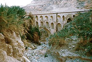
Herod the Great had to rent back the royal estate at Jericho from Cleopatra, who had received it as a gift from Mark Antony. After their deaths in 30 BCE, Octavian (who became the Roman Emperor) gave Herod complete control over Jericho. Herod built a hippodrome-theater (at Tell es-Samrat) for his guests. He also built new aqueducts to water the land below the cliffs and supply his winter palaces at Tulul Abu el-Alaiq. In 2008, a book with pictures of Herod's third Jericho palace was published.
The Roman Jewish historian Josephus wrote that Aristobulus III was murdered in a swimming pool at the Hasmonean royal winter palaces during a party hosted by Herod's mother-in-law. After the palaces were built, Jericho became not only a farming center and a crossroads, but also a winter resort for Jerusalem's rich people.
Herod's son, Herod Archelaus, took over Judea. He built a village called Archelaïs (modern Khirbet al-Beiyudat) nearby. This village housed workers for his date palm plantations.
The writer Strabo described Jericho in the first century CE:
Jericho is a plain surrounded by mountains that slope down like a theater. Here is the Phoenicon, which has all kinds of cultivated and fruitful trees, but mostly palm trees. It is 100 stadia long and is watered by many streams. Here also are the Palace and the Balsam Park.
Jericho in the New Testament
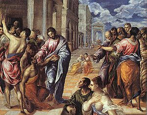
The Christian Gospels say that Jesus of Nazareth passed through Jericho. There, he healed blind beggars (Matthew 20:29) and inspired a local chief tax collector named Zacchaeus to change his dishonest ways (Luke 19:1–10). The road between Jerusalem and Jericho is where the story of the Parable of the Good Samaritan takes place.
Smith's Bible Names Dictionary says that "Jericho was once more 'a city of palms' when our Lord visited it. Here he restored sight to the blind (Matthew 20:30; Mark 10:46; Luke 18:35). Here the descendant of Rahab did not mind the kindness of Zacchaeus the publican. Finally, between Jerusalem and Jericho was the setting for his story of the good Samaritan."
Roman Province: Decline and Forts
After Jerusalem fell to the Roman armies in 70 CE, Jericho quickly declined. By 100 CE, it was just a small Roman army town. A fort was built there in 130 CE and helped put down the Bar Kochba revolt in 133 CE.
Byzantine Period: Christian Growth
A Christian pilgrim wrote about Jericho in 333 CE. Soon after, the old town was abandoned, and a new Byzantine Jericho, called Ericha, was built 1600 meters (1 mile) to the east. The modern city is built around this area. Christianity became strong in the city during the Byzantine era, and many people lived there. Several monasteries and churches were built, including the Monastery of Saint George of Choziba in 340 CE. At least two synagogues were also built in the 6th century CE. The monasteries were abandoned after the Sasanian invasion of 614 CE.
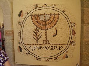
The Jericho synagogue in the Royal Maccabean winter palace dates from 70 to 50 BCE. Another synagogue from the late 6th or early 7th century CE was found in Jericho in 1936. It was named Shalom Al Yisrael Synagogue, meaning "peace unto Israel," after the main Hebrew phrase in its mosaic floor.
The Na'aran synagogue, another Byzantine-era building, was found on the northern edge of Jericho in 1918. It has a larger mosaic and is in similar condition to the Shalom Al Yisrael synagogue.
Early Muslim Period: A Fragrant City Again
Jericho, then called "Ariha" in Arabic, became part of the "Military District of Palestine." By 659 CE, this area was controlled by Mu'awiya, who founded the Umayyad dynasty. That year, an earthquake destroyed Jericho. Ten years later, a pilgrim named Arculf visited Jericho and found it in ruins.
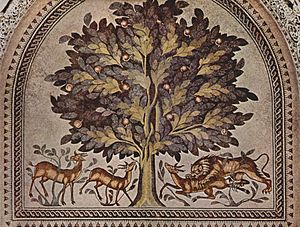
A large palace complex, known as Hisham's Palace, is located about 1.5 kilometers (1 mile) north of Tell es-Sultan. It was likely built by Caliph Walid ibn Yazid (who ruled from 743–744). He was killed before he could finish building it. You can still see the remains of two mosques, a courtyard, and mosaics there today. An earthquake in 747 CE largely destroyed the unfinished structure.
Umayyad rule ended in 750 CE, followed by the Abbasid and Fatimid dynasties. Under Islamic rule, farming with irrigation grew, making Jericho famous again as a fertile "City of the Palms." The Arab geographer Al-Maqdisi wrote in 985 CE that "the water of Jericho is held to be the highest and best in all Islam. Bananas are plentiful, also dates and flowers of fragrant odor."
Crusader Period: Sugar Production
In 1179, the Crusaders rebuilt the Monastery of St. George of Koziba, about 10 kilometers (6 miles) from the city center. They also built two other churches and a monastery. Some people in the 19th century thought the Crusaders brought sugarcane production to the city. However, experts now believe it started earlier, in the Early Arab period. The Crusaders did, however, greatly increase sugar production. The site of Tawahin es-Sukkar (meaning "sugar mills") has remains of a Crusader sugar factory. In 1187, the Crusaders were forced out by Saladin's forces after their victory in the Battle of Hattin, and the town slowly declined.
Ottoman Period: A Quiet Village
Jericho became part of the Ottoman Empire in 1517. In 1545, records show that the city's income went to a new religious charity in Jerusalem. Villagers made money by processing indigo. Later in that century, Jericho's income no longer went to that charity.
In 1596, tax records show Jericho (called Riha) had 51 households, all Muslim. They paid taxes on farm products like wheat, barley, summer crops, vineyards, fruit trees, goats, and beehives.
A French traveler named Laurent d'Arvieux described the city in 1659 as "now desolate, and consists only of about fifty poor houses." He noted that the plain around it was very fertile, watered by several small rivers flowing into the Jordan.
19th Century Visits
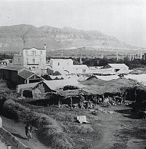
In the 1800s, European scholars, archaeologists, and missionaries often visited Jericho. At that time, it was a poor oasis, similar to other areas in the plains and deserts. Edward Robinson (1838) reported 50 families, about 200 people. Titus Tobler (1854) reported about 30 poor huts. Abraham Samuel Herschberg (1899–1900) also reported about 30 poor huts and 300 residents. At that time, Jericho was where the Turkish governor of the region lived. The main water sources were a spring called Ein al-Sultan (Sultan's Spring) and springs in Wadi Qelt.
An Ottoman village list from around 1870 showed that Riha (Jericho) had 36 houses and 105 male residents. The first archaeological dig at Tell es-Sultan happened in 1867.
20th Century Changes
The Greek Orthodox monasteries of St. George of Choziba and John the Baptist were rebuilt and finished in 1901 and 1904.
British Mandate Period
After the Ottoman Empire fell at the end of World War I, Jericho came under British rule as part of Mandatory Palestine.
According to the 1922 census of Palestine, Jericho had 1,029 people. Most were Muslims (931), with 92 Christians and six Jews. In 1927, an earthquake hit Jericho and other cities, killing about 300 people. By the 1931 census, the population had grown to 1,693 people in 347 houses.
In 1945, Jericho's population was 3,010. Most (94%) were Arab, and 6% were Jewish. During World War II, the British built fortresses in Jericho and prepared bridges with explosives in case German forces invaded.
Jordanian Period
Jericho came under Jordanian control after the 1948 Arab–Israeli War. The Jericho Conference in 1948, attended by over 2,000 Palestinian representatives, declared King Abdullah as King of all Palestine. It also called for Palestine and Transjordan to unite. In mid-1950, Jordan officially took control of the West Bank, and Jericho residents became Jordanian citizens.
In 1961, Jericho's population was 10,166, with most being Muslim and 935 Christian.
1967 and Beyond
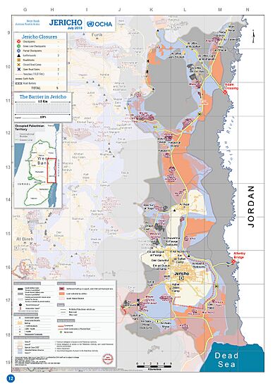
Jericho has been under occupation by Israel since the Six-Day War of 1967. It was the first city given to Palestinian Authority control under the Oslo Accords in 1994. Part of this agreement was an "Economic Relations Protocol." Jericho is in an area of the West Bank called Area A, which is under Palestinian control. However, the surrounding area is Area C, under full Israeli military control. Four roadblocks surround Jericho, limiting how Palestinians can move in and out of the city.
In 2001, during the Second Intifada, Israeli troops re-occupied Jericho. A 2-meter (6.6 ft) deep trench was built around much of the city to control traffic.
Jericho's Location and Environment
Jericho is located 258 meters (846 ft) below sea level in an oasis in Wadi Qelt. This makes it the lowest city in the world. The nearby spring of Ein es-Sultan produces a lot of water, about 3.8 cubic meters (1,000 gallons) per minute. This water irrigates about 2,500 acres (10 square kilometers) of land through many channels and flows into the Jordan River, which is 6 miles (9.7 km) away.
Important Bird Area
A large area of 3,500 hectares (8,600 acres) around Jericho has been named an Important Bird Area (IBA) by BirdLife International. This is because it is home to many birds, including black francolins, lanner falcons, lesser kestrels, and Dead Sea sparrows.
Climate: Hot Desert Oasis
Jericho receives about 204 millimeters (8 inches) of rain each year, mostly in winter and early spring. The average temperature is 11°C (52°F) in January and 31°C (88°F) in July. According to the Köppen climate classification, Jericho has a hot desert climate (BWh). The rich soil and plenty of spring water have made Jericho an appealing place for people to live for a very long time.
| Climate data for Jericho | |||||||||||||
|---|---|---|---|---|---|---|---|---|---|---|---|---|---|
| Month | Jan | Feb | Mar | Apr | May | Jun | Jul | Aug | Sep | Oct | Nov | Dec | Year |
| Mean daily maximum °C (°F) | 19.0 (66.2) |
20.6 (69.1) |
24.4 (75.9) |
29.5 (85.1) |
34.4 (93.9) |
37.0 (98.6) |
38.6 (101.5) |
37.9 (100.2) |
35.8 (96.4) |
32.7 (90.9) |
28.1 (82.6) |
21.4 (70.5) |
30.0 (86.0) |
| Daily mean °C (°F) | 10.7 (51.3) |
12.6 (54.7) |
16.3 (61.3) |
22.4 (72.3) |
26.6 (79.9) |
30.4 (86.7) |
30.9 (87.6) |
30.4 (86.7) |
28.6 (83.5) |
25.8 (78.4) |
22.8 (73.0) |
16.9 (62.4) |
22.9 (73.2) |
| Mean daily minimum °C (°F) | 4.4 (39.9) |
5.9 (42.6) |
9.6 (49.3) |
13.6 (56.5) |
18.2 (64.8) |
20.2 (68.4) |
21.9 (71.4) |
21.1 (70.0) |
20.5 (68.9) |
17.6 (63.7) |
16.6 (61.9) |
11.6 (52.9) |
15.1 (59.2) |
| Average precipitation mm (inches) | 59 (2.3) |
44 (1.7) |
20 (0.8) |
4 (0.2) |
1 (0.0) |
0 (0) |
0 (0) |
1 (0.0) |
2 (0.1) |
3 (0.1) |
5 (0.2) |
65 (2.6) |
204 (8.0) |
| Average relative humidity (%) | 77 | 81 | 74 | 62 | 49 | 50 | 51 | 57 | 52 | 56 | 54 | 74 | 61 |
| Mean monthly sunshine hours | 189.1 | 186.5 | 244.9 | 288.0 | 362.7 | 393.0 | 418.5 | 396.8 | 336.0 | 294.5 | 249.0 | 207.7 | 3,566.7 |
| Mean daily sunshine hours | 6.1 | 6.6 | 7.9 | 9.6 | 11.7 | 13.1 | 13.5 | 12.8 | 11.2 | 9.5 | 8.3 | 6.7 | 9.8 |
| Source: Arab Meteorology Book | |||||||||||||
Who Lives in Jericho? Demographics
In 1997, the first census by the Palestinian Central Bureau of Statistics (PCBS) showed Jericho's population was 14,674. A large part of the residents (43.6% or 6,393 people) were Palestinian refugees. The population was almost evenly split between males (51%) and females (49%). Jericho has a young population, with nearly half (49.2%) of its people under 20 years old. In the 2007 census, Jericho had 18,346 people.
Over thousands of years, the types of people living in Jericho have changed a lot. Today, most of the people are Muslim. The Christian community makes up about 1% of the population. There is also a large community of black Palestinians in Jericho.
Jericho's Economy and Jobs
In 1994, Israel and Palestine signed an economic agreement. This allowed Palestinians in Jericho to open banks, collect taxes, and trade goods. This was a step towards self-rule for the city.
Farming is another important way people make money in Jericho. There are many banana farms around the city. The Jericho Agro-Industrial Park is a project being built in the area. Companies that process farm products are offered financial benefits to set up businesses in the park. This aims to help Jericho's economy grow.
Visiting Jericho: Tourism
In 1998, a large casino-hotel was built in Jericho. While the casino is now closed, the hotel is still open for guests. In 2010, Jericho was named the most popular place for Palestinian tourists to visit, partly because it is close to the Dead Sea.
Biblical and Christian Sites to See
Christian tourism is a main source of income for Jericho. There are several important Christian pilgrimage sites in and around the city:
- Ein es-Sultan, known as the Spring of Elisha to Jews and Christians.
- Qasr al-Yahud on the Jordan River, believed to be where Jesus was baptized.
- Mount of Temptation (Jebel Quruntul), traditionally where Jesus was tempted.
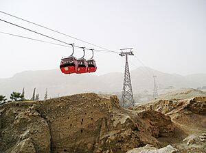
- The Greek Orthodox Monastery of the Temptation is halfway up the mountain, next to a cave where Jesus is said to have fasted for 40 days. You can reach it by a cable car from Jericho.
- Two sycamore trees are mentioned in relation to Zacchaeus in the Bible.
- Deir Hajla, the monastery of St. Gerasimos in the Jordan Valley near Jericho.
- Saint George Monastery in Wadi Qelt above Jericho.
Archaeological Sites to Explore
- Stone, Bronze, and Iron Age cities at Tell es-Sultan.
- Hasmonean and Herodian winter palaces at Tulul Abu el-'Alayiq.
- Byzantine-period synagogues at Jericho (Shalom Al Yisrael Synagogue) and Na'aran.
- Umayyad palace at Khirbet al-Mafjar, known as Hisham's Palace.
- Crusader sugar production facility at Tawahin es-Sukkar (meaning "sugar mills").
- Nabi Musa, a shrine believed by Muslims to be the resting place of Moses.
Schools and Religious Places
In 1925, Christian friars opened a school for 100 students, which became the Terra Santa School. The city has 22 public schools and several private schools.
Sports in Jericho
The sports team Hilal Areeha plays association football (soccer) in the West Bank First Division. They play their home games at the 15,000-seat Jericho International Stadium.
Jericho's Sister Cities
Jericho is twinned with several cities around the world:
 Alessandria, Italy (2004)
 Campinas, Brazil (2001)
 Eger, Hungary (2013)
 Estación Central, Chile (2007)
 Fez, Morocco (2014)
 Foz do Iguaçu, Brazil (2012)
 Iași, Romania (2003)
 Ilion, Greece (1999)
 Kragujevac, Serbia (2011)
 Lærdal, Norway (1998)
 Pisa, Italy (2000)
 San Giovanni Valdarno, Italy (2004)
 Santa Bárbara, Brazil (1998)
 Al-Shuna al-Shamalyah, Jordan (2016)
Notable People from Jericho
- Musa Alami
|
See also
 In Spanish: Jericó para niños
 | Stephanie Wilson |
 | Charles Bolden |
 | Ronald McNair |
 | Frederick D. Gregory |


