Piri Reis map facts for kids
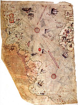
The Piri Reis map is a famous map of the world. It was drawn in 1513 by a Turkish admiral and cartographer named Piri Reis. He drew it on a piece of gazelle skin. This map is special because it seems to show parts of Antarctica. This is surprising because Antarctica was officially discovered much later, in 1773, by Sir James Cook.
Contents
The Piri Reis Map
The Piri Reis map is one of the oldest maps that shows parts of the Americas. It was made in the early 16th century. The map is not a complete world map. It only shows the western part of the world. This includes the coasts of Africa, Europe, and South America. It also shows the Caribbean Sea and parts of Central America.
Who Was Piri Reis?
Piri Reis was a very important person in the Ottoman Empire. His full name was Hadji Muhiddin Piri Ibn Hadji Mehmed. He was an admiral in the Ottoman navy. He was also a cartographer, which means he was a mapmaker. Piri Reis was known for his detailed maps and books about sailing. He wrote a famous book called Kitab-ı Bahriye, which means "Book of Navigation". This book had many maps and information for sailors.
What Makes This Map Special?
The Piri Reis map is unique for several reasons. One big reason is the possible depiction of Antarctica. This continent was not known to Europeans in 1513. Some people believe the map shows the coast of Antarctica before it was covered by ice. This idea is debated by experts.
Sources of the Map
Piri Reis wrote notes on his map. He said he used many older maps to create his own. These included maps from the time of Alexander the Great. He also used maps drawn by Christopher Columbus. Columbus explored the Americas a few years before Piri Reis made his map. Piri Reis combined information from these different sources. This helped him create a very detailed map for his time.
Discovery and Location
The Piri Reis map was found in 1929. It was discovered in the Topkapı Palace in Istanbul, Turkey. The map is now kept in the Topkapı Palace Museum. It is a valuable historical artifact. It helps us understand how people viewed the world centuries ago.
See also
 In Spanish: Mapa de Piri Reis para niños
 | Shirley Ann Jackson |
 | Garett Morgan |
 | J. Ernest Wilkins Jr. |
 | Elijah McCoy |


